
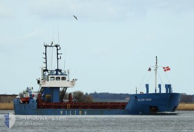
WILSON MAAS
General Cargo
Current Trip
| Time Travelled | 11 days |
|---|---|
| Remaining Time | --- |
| Distance Travelled | 414.18 nm |
| Remaining Distance | --- |
| AVG Speed | 9.3 Knopen |
| MAX Speed | 11.7 Knopen |
| AVG Wind | 14.2 knots |
| MAX Wind | 33 knots |
| MIN Temp | -10°C / 14°F |
| MAX Temp | 9.1°C / 48.38°F |
| Diepgang | 3.2 M |
| Positie ontvangen | 5 m geleden |
Current Position
| Lengtegraad | --- |
|---|---|
| Breedtegraat | --- |
| Status | At anchor |
| Snelheid | 0.1 Knopen |
| Koers | 306° |
| Gebied | North Sea |
| Station | T-AIS |
| Positie ontvangen | 5 m geleden |
Info
Information
The current position of WILSON MAAS is in North Sea with coordinates 59.30141° / 5.32356° as reported on 2025-01-03 18:03 by AIS to our vessel tracker app. The vessel's current speed is 0.1 Knopen
The vessel WILSON MAAS (IMO: 9145554, MMSI: 314217000) is a General Cargo that was built in 1997 ( 28 Jaar oud ). It's sailing under the flag of [BB] Barbados.
In this page you can find informations about the vessels current position, last detected port calls, and current voyage information. If the vessels is not in coverage by AIS you will find the latest position.
The current position of WILSON MAAS is detected by our AIS receivers and we are not responsible for the reliability of the data. The last position was recorded while the vessel was in Coverage by the Ais receivers of our vessel tracking app.
The current draught of WILSON MAAS as reported by AIS is 3.2 meters
Weather
| Temperature | 2.6°C / 36.68°F |
|---|---|
| Wind Speed | 18 knots |
| Direction | 343° NNW |
| Pressure | 1010 hPa |
| Humidity | 52.1 % |
| Cloud Coverage | 100 % |
Featured Company
Last Port Calls
| Port | Arrival | Departure | Time In Port |
|---|---|---|---|
| 2024-12-22 13:48 | 2024-12-23 10:45 | 20 h | |
| 2024-12-15 18:02 | 2024-12-17 16:58 | 1 d | |
| 2024-12-12 07:57 | 2024-12-13 11:55 | 1 d | |
| 2024-12-10 09:21 | 2024-12-10 13:13 | 3 h | |
| 2024-12-05 22:49 | 2024-12-06 13:14 | 14 h | |
| 2024-12-03 22:12 | 2024-12-05 13:06 | 1 d | |
| 2024-12-03 00:58 | 2024-12-03 02:50 | 1 h | |
| 2024-11-29 08:36 | 2024-11-29 21:16 | 12 h | |
| 2024-11-20 20:59 | 2024-11-22 09:56 | 1 d | |
| 2024-11-17 12:24 | 2024-11-18 14:32 | 1 d |
Most Visited Ports (Last year)
| Port | Arrivals | |
|---|---|---|
| 6 | ||
| 6 | ||
| 5 | ||
| 5 | ||
| 4 | ||
| 4 |
Last Trips
| Origin | Departure | Destination | Arrival | Distance | |
|---|---|---|---|---|---|
| 2024-12-17 17:58 | 2024-12-22 14:48 | 219.14 nm | |||
| 2024-12-13 12:55 | 2024-12-15 19:02 | 420.25 nm | |||
| 2024-12-10 14:13 | 2024-12-12 08:57 | 429.82 nm | |||
| 2024-12-06 14:14 | 2024-12-10 10:21 | 682.10 nm | |||
| 2024-12-05 14:06 | 2024-12-05 23:49 | 70.55 nm | |||
| 2024-12-03 03:50 | 2024-12-03 23:12 | 104.08 nm | |||
| 2024-11-29 22:16 | 2024-12-03 01:58 | 510.75 nm | |||
| 2024-11-22 09:56 | 2024-11-29 09:36 | 608.10 nm | |||
| 2024-11-18 15:32 | 2024-11-20 20:59 | 272.93 nm | |||
| 2024-11-15 21:12 | 2024-11-17 13:24 | 81.78 nm |
Events
| Tijd | Evenement | Details | Positie / Bestemming | Info |
|---|---|---|---|---|
| 2025-01-03 10:06 | Status Changed | At anchor Default |
59.30122 / 5.32160
TANANGER
|
Snelheid: Koers: 23° |
| 2025-01-03 10:03 | Status Changed | Default At anchor |
59.30119 / 5.32168
TANANGER
|
Snelheid: 0.1 kn Koers: 20° |
| 2025-01-01 14:57 | ETA Changed | 2025/01/04 08:00 2025/12/28 01:00 |
59.30241 / 5.32275
TANANGER
|
Snelheid: 0.8 kn Koers: 305° |
| 2025-01-01 14:56 | Status Changed | At anchor Under way using engine |
59.30241 / 5.32276
TANANGER
|
Snelheid: 0.5 kn Koers: 306° |
| 2025-01-01 14:48 | Stop beweging | 0.75 nm, South of KARMOY |
59.30205 / 5.32406
TANANGER
|
Snelheid: 0.2 kn Koers: 325° |
| 2025-01-01 01:28 | Wijzig zee gebeid | Norwegian part of the North Sea Norwegian part of the Norwegian Sea |
60.99099 / 4.31196
North Sea
|
Snelheid: 9.6 kn Koers: 167.8° |
| 2025-01-01 00:05 | ETA Changed | 2025/12/28 01:00 2024/12/28 01:00 |
61.21621 / 4.30509
TANANGER
|
Snelheid: 9.6 kn Koers: 180.2° |
| 2024-12-31 12:07 | Start beweging | 1.64 nm, North East of ALESUND |
62.48285 / 6.19625
TANANGER
|
Snelheid: 6.1 kn Koers: 354.8° |
| 2024-12-31 12:01 | Status Changed | Under way using engine Moored |
62.48062 / 6.19299
TANANGER
|
Snelheid: 0.3 kn Koers: 268° |
| 2024-12-31 11:34 | Destination Changed | TANANGER NOAES |
62.48071 / 6.19186
TANANGER
|
Snelheid: 0.1 kn Koers: 267° |