

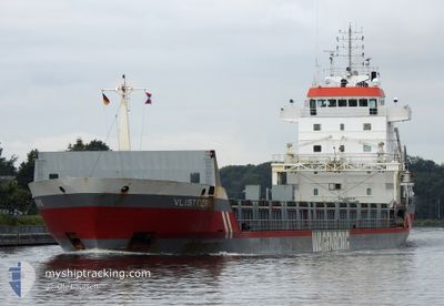
VLISTBORG
General Cargo

Current Trip
| Time Travelled | 1 day |
|---|---|
| Remaining Time | 1 h, 48 mins |
| Distance Travelled | 270.46 nm |
| Remaining Distance | 21.01 nm |
| AVG Speed | 8.9 Knopen |
| MAX Speed | 16.3 Knopen |
| AVG Wind | 6.2 knots |
| MAX Wind | 17 knots |
| MIN Temp | 4.9°C / 40.82°F |
| MAX Temp | 9.6°C / 49.28°F |
| Diepgang | 4.6 M |
| Positie ontvangen | 1 m geleden |
Current Position
| Lengtegraad | --- |
|---|---|
| Breedtegraat | --- |
| Status | Under way using engine |
| Snelheid | 10.4 Knopen |
| Koers | 81.4° |
| Gebied | North Sea |
| Station | T-AIS |
| Positie ontvangen | 1 m geleden |
Information
The current position of VLISTBORG is in North Sea with coordinates 51.40140° / 3.17929° as reported on 2025-03-28 06:28 by AIS to our vessel tracker app. The vessel's current speed is 10.4 Knopen and is heading at the port of VLISSINGEN. The estimated time of arrival as calculated by MyShipTracking vessel tracking app is 2025-03-28 09:17 LT
The vessel VLISTBORG (IMO: 9160346, MMSI: 244850612) is a General Cargo that was built in 1999 ( 26 Jaar oud ). It's sailing under the flag of [NL] Netherlands.
In this page you can find informations about the vessels current position, last detected port calls, and current voyage information. If the vessels is not in coverage by AIS you will find the latest position.
The current position of VLISTBORG is detected by our AIS receivers and we are not responsible for the reliability of the data. The last position was recorded while the vessel was in Coverage by the Ais receivers of our vessel tracking app.
The current draught of VLISTBORG as reported by AIS is 4.6 meters
Weather
| Temperature | 6.8°C / 44.24°F |
|---|---|
| Wind Speed | 17 knots |
| Direction | 241° WSW |
| Pressure | 1013.3 hPa |
| Humidity | 93.3 % |
| Cloud Coverage | 40 % |


Featured Company
Last Port Calls
| Port | Arrival | Departure | Time In Port |
|---|---|---|---|
| 2025-03-22 17:25 | 2025-03-26 20:26 | 4 d | |
| 2025-03-15 21:14 | 2025-03-17 07:11 | 1 d | |
| 2025-03-09 23:55 | 2025-03-12 20:54 | 2 d | |
| 2025-02-20 06:57 | 2025-02-22 18:55 | 2 d | |
| 2025-02-06 08:55 | 2025-02-17 17:46 | 11 d | |
| 2025-02-03 02:34 | 2025-02-03 09:19 | 6 h | |
| 2025-01-18 09:33 | 2025-01-19 20:27 | 1 d | |
| 2025-01-14 15:41 | 2025-01-15 17:53 | 1 d | |
| 2025-01-11 12:45 | 2025-01-12 10:53 | 22 h | |
| 2025-01-03 10:15 | 2025-01-09 18:58 | 6 d |
Most Visited Ports (Last year)
| Port | Arrivals | |
|---|---|---|
| 4 | ||
| 3 | ||
| 2 | ||
| 2 | ||
| 2 | ||
| 2 |
Last Trips
| Origin | Departure | Destination | Arrival | Distance | |
|---|---|---|---|---|---|
| 2025-03-17 07:11 | 2025-03-22 17:25 | 1195.65 nm | |||
| 2025-03-12 20:54 | 2025-03-15 21:14 | 486.11 nm | |||
| 2025-02-22 18:55 | 2025-03-09 23:55 | 3079.15 nm | |||
| 2025-02-17 17:46 | 2025-02-20 06:57 | 655.94 nm | |||
| 2025-02-03 09:19 | 2025-02-06 08:55 | 698.85 nm | |||
| 2025-01-19 20:27 | 2025-02-03 02:34 | 2371.67 nm | |||
| 2025-01-15 17:53 | 2025-01-18 09:33 | 627.39 nm | |||
| 2025-01-12 10:53 | 2025-01-14 15:41 | 511.94 nm | |||
| 2025-01-09 18:58 | 2025-01-11 12:45 | 372.19 nm | |||
| 2024-12-26 19:34 | 2025-01-03 10:15 | 1860.00 nm |
Events
| Tijd | Evenement | Details | Positie / Bestemming | Info |
|---|---|---|---|---|
| 2025-03-28 02:58 | Gevonden in zee | Belgian part of the North Sea |
51.32605 / 2.36733
North Sea
NLVLI
|
Snelheid: 6.5 kn Koers: 55.9° |
| 2025-03-27 21:49 | Gevonden in zee | French part of the North Sea |
51.00872 / 1.60882
North Sea
NLVLI
|
Snelheid: 7.5 kn Koers: 43.3° |
| 2025-03-27 20:59 | Start beweging | 12.88 nm, North of BOULOGNE-SUR-MER |
50.93397 / 1.49889
NLVLI
|
Snelheid: 7.4 kn Koers: 41.4° |
| 2025-03-27 20:59 | Status Changed | Under way using engine Default |
50.93290 / 1.49740
NLVLI
|
Snelheid: Koers: 0° |
| 2025-03-27 20:58 | Status Changed | Default Under way using engine |
50.93244 / 1.49675
NLVLI
|
Snelheid: 7.4 kn Koers: 41.9° |
| 2025-03-27 20:58 | Stop beweging | 12.82 nm, North of BOULOGNE-SUR-MER |
50.93244 / 1.49675
NLVLI
|
Snelheid: Koers: 0° |
| 2025-03-27 17:53 | Status Changed | Under way using engine Default |
50.62488 / 1.24758
NLVLI
|
Snelheid: 6.8 kn Koers: 45° |
| 2025-03-27 17:46 | Status Changed | Default Under way using engine |
50.61572 / 1.23306
NLVLI
|
Snelheid: 6.6 kn Koers: 48.3° |
| 2025-03-27 16:05 | Status Changed | Under way using engine Default |
50.48417 / 1.02028
NLVLI
|
Snelheid: 6.1 kn Koers: 39° |
| 2025-03-27 16:02 | Status Changed | Default Under way using engine |
50.48053 / 1.01486
NLVLI
|
Snelheid: 6.5 kn Koers: 74.2° |