
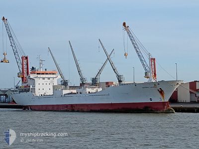
SIERRA LAUREL
Reefer
Current Trip
AGADIR
| Time Travelled | 5 h, 59 mins |
|---|---|
| Remaining Time | --- |
| Distance Travelled | 46.65 nm |
| Remaining Distance | --- |
| AVG Speed | 12 Knopen |
| MAX Speed | 14.4 Knopen |
| AVG Wind | 18.2 knots |
| MAX Wind | 26 knots |
| MIN Temp | 18.8°C / 65.84°F |
| MAX Temp | 20°C / 68°F |
| Diepgang | 6.3 M |
| Positie ontvangen | 5 d geleden |
Current Position
| Lengtegraad | --- |
|---|---|
| Breedtegraat | --- |
| Status | At anchor |
| Snelheid | 0.2 Knopen |
| Koers | 167° |
| Gebied | North Atlantic Ocean |
| Station | T-AIS |
| Positie ontvangen | 5 d geleden |
Info
Information
The current position of SIERRA LAUREL is in North Atlantic Ocean with coordinates 30.42116° / -9.67506° as reported on 2024-10-20 19:32 by AIS to our vessel tracker app. The vessel's current speed is 0.2 Knopen
The vessel SIERRA LAUREL (IMO: 9163403, MMSI: 311001187) is a Reefer that was built in 1998 ( 26 Jaar oud ). It's sailing under the flag of [BS] Bahamas.
In this page you can find informations about the vessels current position, last detected port calls, and current voyage information. If the vessels is not in coverage by AIS you will find the latest position.
The current position of SIERRA LAUREL is detected by our AIS receivers and we are not responsible for the reliability of the data. The last position was recorded while the vessel was in Coverage by the Ais receivers of our vessel tracking app.
The current draught of SIERRA LAUREL as reported by AIS is 6.3 meters
Weather
| Temperature | 19°C / 66.2°F |
|---|---|
| Wind Speed | 26 knots |
| Direction | 25° NNE |
| Pressure | 1020.3 hPa |
| Humidity | 81.3 % |
| Cloud Coverage | 3 % |
Featured Company
Last Port Calls
| Port | Arrival | Departure | Time In Port |
|---|---|---|---|
| 2024-10-21 07:51 | 2024-10-25 23:28 | 4 d | |
| 2024-10-16 05:32 | 2024-10-16 16:38 | 11 h | |
| 2024-10-08 18:51 | 2024-10-13 01:19 | 4 d | |
| 2024-09-22 21:43 | 2024-10-06 19:35 | 13 d | |
| 2024-08-30 17:37 | 2024-09-03 18:17 | 4 d | |
| 2024-08-17 10:45 | 2024-08-22 04:01 | 4 d |
Most Visited Ports (Last year)
| Port | Arrivals | |
|---|---|---|
| 2 | ||
| 2 | ||
| 1 | ||
| 1 | ||
| 1 | ||
| 1 |
Last Trips
| Origin | Departure | Destination | Arrival | Distance | |
|---|---|---|---|---|---|
| 2024-10-16 17:38 | 2024-10-21 08:51 | 363.88 nm | |||
| 2024-10-13 01:19 | 2024-10-16 06:32 | 863.75 nm | |||
| 2024-10-06 19:35 | 2024-10-08 18:51 | 15.98 nm | |||
| 2024-09-03 19:17 | 2024-09-22 21:43 | 2676.05 nm | |||
| 2024-08-22 05:01 | 2024-08-30 18:37 | 955.05 nm | |||
| 2024-07-29 23:06 | 2024-08-17 11:45 | 2571.80 nm |
Events
| Tijd | Evenement | Details | Positie / Bestemming | Info |
|---|---|---|---|---|
| 2024-10-25 23:28 | Vertrekhaven |
|
30.44511 / -9.73524
AGADIR
|
Snelheid: Koers: 322° |
| 2024-10-21 08:17 | Stop beweging |
30.42583 / -9.64796
[MA] AGADIR
|
Snelheid: Koers: 324° |
|
| 2024-10-21 07:51 | Aankomsthaven |
|
30.41986 / -9.64128
[MA] AGADIR
|
Snelheid: 3.8 kn Koers: 7° |
| 2024-10-20 19:41 | Status Changed | Default At anchor |
30.42100 / -9.67530
AGADIR
|
Snelheid: 0.2 kn Koers: 167° |
| 2024-10-20 19:32 | Buitenbereik |
30.42116 / -9.67506
North Atlantic Ocean
|
Snelheid: 0.2 kn Koers: 315.4° |
|
| 2024-10-20 18:44 | Status Changed | At anchor Default |
30.42081 / -9.67393
AGADIR
|
Snelheid: 0.3 kn Koers: 220° |
| 2024-10-20 18:44 | Binnenbereik |
30.42081 / -9.67393
North Atlantic Ocean
|
Snelheid: 0.5 kn Koers: 223.2° |
|
| 2024-10-20 16:02 | Status Changed | Default At anchor |
30.42006 / -9.67337
AGADIR
|
Snelheid: 0.3 kn Koers: 251° |
| 2024-10-20 15:58 | Buitenbereik |
30.42002 / -9.67342
North Atlantic Ocean
|
Snelheid: 0.3 kn Koers: 275.2° |
|
| 2024-10-20 15:39 | Status Changed | At anchor Default |
30.42009 / -9.67342
AGADIR
|
Snelheid: 0.1 kn Koers: 257° |