
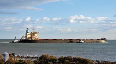
NSU YOUNG STAR
Cargo
Current Trip
| Trip Time | 5 days |
|---|---|
| Trip Distance | 1495.11 nm |
| AVG Speed | 10.9 Knopen |
| MAX Speed | 13.7 Knopen |
| Diepgang | 11.5 M |
| AVG Wind | 11.1 knots |
| MAX Wind | 35.4 knots |
| MIN Temp | 6.8°C / 44.24°F |
| MAX Temp | 23.6°C / 74.48°F |
| Positie ontvangen | 2 d geleden |
Current Position
| Lengtegraad | 120.96928° |
|---|---|
| Breedtegraat | 26.52210° |
| Status | Under way using engine |
| Snelheid | 10.6 Knopen |
| Koers | 273.3° |
| Gebied | Eastern China Sea |
| Station | T-AIS |
| Positie ontvangen | 2 d geleden |
Info
Information
The current position of NSU YOUNG STAR is in Eastern China Sea with coordinates 26.52210° / 120.96928° as reported on 2024-05-07 14:43 by AIS to our vessel tracker app. The vessel's current speed is 10.6 Knopen and is currently inside the port of LUOYUAN.
The vessel NSU YOUNG STAR (IMO: 9839026, MMSI: 636019353) is a Cargo It's sailing under the flag of [LR] Liberia.
In this page you can find informations about the vessels current position, last detected port calls, and current voyage information. If the vessels is not in coverage by AIS you will find the latest position.
The current position of NSU YOUNG STAR is detected by our AIS receivers and we are not responsible for the reliability of the data. The last position was recorded while the vessel was in Coverage by the Ais receivers of our vessel tracking app.
The current draught of NSU YOUNG STAR as reported by AIS is 11.5 meters
Weather
| Temperature | 16.9°C / 62.42°F |
|---|---|
| Wind Speed | 5 knots |
| Direction | 346° NNW |
| Pressure | 1020.2 hPa |
| Humidity | 80.6 % |
| Cloud Coverage | 100 % |
Featured Company
Last Trips
Events
| Tijd | Evenement | Details | Positie / Bestemming | Info |
|---|---|---|---|---|
| 2024-05-08 03:56 | Stop beweging |
26.44123 / 119.70814
[CN] LUOYUAN
|
Snelheid: 0.2 kn Koers: 344° |
|
| 2024-05-08 03:04 | Aankomsthaven |
|
26.41152 / 119.75257
[CN] LUOYUAN
|
Snelheid: 7.3 kn Koers: 303° |
| 2024-05-07 22:12 | Start beweging |
26.48513 / 120.37803
JP MUR > CN FOC
|
Snelheid: 3.7 kn Koers: 269° |
|
| 2024-05-07 18:36 | Stop beweging |
26.47998 / 120.38406
JP MUR > CN FOC
|
Snelheid: 0.3 kn Koers: 325° |
|
| 2024-05-07 14:48 | Status Changed | Default Under way using engine |
26.52097 / 120.95368
JP MUR > CN FOC
|
Snelheid: 10.6 kn Koers: 273.3° |
| 2024-05-07 14:43 | Status Changed | Under way using engine Default |
26.52210 / 120.96928
JP MUR > CN FOC
|
Snelheid: 10.5 kn Koers: 275° |
| 2024-05-07 14:43 | Buitenbereik |
26.52210 / 120.96928
Eastern China Sea
JP MUR > CN FOC
|
Snelheid: 10.6 kn Koers: 273.3° |
|
| 2024-05-07 14:36 | Binnenbereik |
26.52210 / 120.96928
Eastern China Sea
JP MUR > CN FOC
|
Snelheid: 10.6 kn Koers: 273.3° |
|
| 2024-05-07 13:37 | Status Changed | Default Under way using engine |
26.57806 / 121.18530
JP MUR > CN FOC
|
Snelheid: 11.4 kn Koers: 252° |
| 2024-05-07 13:29 | Buitenbereik |
26.58502 / 121.20979
Eastern China Sea
JP MUR > CN FOC
|
Snelheid: 11.4 kn Koers: 252° |