

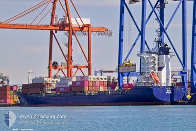
MITO
Cargo/Container Ship

Current Trip
| Time Travelled | 3 days |
|---|---|
| Remaining Time | 22 h, 30 mins |
| Distance Travelled | 995.78 nm |
| Remaining Distance | 295.84 nm |
| AVG Speed | 13.7 Knopen |
| MAX Speed | 15.6 Knopen |
| AVG Wind | 15.2 knots |
| MAX Wind | 24 knots |
| MIN Temp | 11.2°C / 52.16°F |
| MAX Temp | 14.6°C / 58.28°F |
| Diepgang | 7.6 M |
| Positie ontvangen | Nu |
Current Position
| Lengtegraad | --- |
|---|---|
| Breedtegraat | --- |
| Status | Under way using engine |
| Snelheid | 12.7 Knopen |
| Koers | 315° |
| Gebied | Adriatic Sea |
| Station | T-AIS |
| Positie ontvangen | Nu |
Information
The current position of MITO is in Adriatic Sea with coordinates 41.88514° / 16.81848° as reported on 2025-02-13 04:48 by AIS to our vessel tracker app. The vessel's current speed is 12.7 Knopen and is heading at the port of KOPER. The estimated time of arrival as calculated by MyShipTracking vessel tracking app is 2025-02-14 03:19 LT
The vessel MITO (IMO: 9319571, MMSI: 255806508) is a Cargo/Container Ship that was built in 2006 ( 19 Jaar oud ). It's sailing under the flag of [PT] Portugal.
In this page you can find informations about the vessels current position, last detected port calls, and current voyage information. If the vessels is not in coverage by AIS you will find the latest position.
The current position of MITO is detected by our AIS receivers and we are not responsible for the reliability of the data. The last position was recorded while the vessel was in Coverage by the Ais receivers of our vessel tracking app.
The current draught of MITO as reported by AIS is 7.6 meters
Weather
| Temperature | 12.7°C / 54.86°F |
|---|---|
| Wind Speed | 8 knots |
| Direction | 197° SSW |
| Pressure | 1020.2 hPa |
| Humidity | 73.6 % |
| Cloud Coverage | 84 % |


Featured Company
Last Port Calls
| Port | Arrival | Departure | Time In Port |
|---|---|---|---|
| 2025-02-09 03:52 | 2025-02-10 03:40 | 23 h | |
| 2025-02-08 08:13 | 2025-02-08 17:11 | 8 h | |
| 2025-02-02 08:14 | 2025-02-04 04:52 | 1 d | |
| 2025-01-25 06:26 | 2025-01-25 18:53 | 12 h | |
| 2025-01-23 19:00 | 2025-01-24 08:28 | 13 h | |
| 2025-01-17 01:34 | 2025-01-18 12:47 | 1 d | |
| 2025-01-14 11:46 | 2025-01-15 04:28 | 16 h | |
| 2025-01-12 02:24 | 2025-01-12 11:46 | 9 h | |
| 2025-01-10 20:36 | 2025-01-11 06:02 | 9 h | |
| 2025-01-09 02:37 | 2025-01-10 09:52 | 1 d |
Last Trips
| Origin | Departure | Destination | Arrival | Distance | |
|---|---|---|---|---|---|
| 2025-02-08 19:11 | 2025-02-09 05:52 | 125.63 nm | |||
| 2025-02-04 06:52 | 2025-02-08 10:13 | 610.89 nm | |||
| 2025-01-25 19:53 | 2025-02-02 10:14 | 988.34 nm | |||
| 2025-01-24 09:28 | 2025-01-25 07:26 | 76.86 nm | |||
| 2025-01-18 14:47 | 2025-01-23 20:00 | 1293.35 nm | |||
| 2025-01-15 06:28 | 2025-01-17 03:34 | 161.68 nm | |||
| 2025-01-12 13:46 | 2025-01-14 13:46 | 115.42 nm | |||
| 2025-01-11 08:02 | 2025-01-12 04:24 | 295.02 nm | |||
| 2025-01-10 11:52 | 2025-01-10 22:36 | 129.56 nm | |||
| 2025-01-08 17:13 | 2025-01-09 04:37 | 158.56 nm |
Events
| Tijd | Evenement | Details | Positie / Bestemming | Info |
|---|---|---|---|---|
| 2025-02-13 04:01 | Binnenbereik |
41.77036 / 16.97928
Adriatic Sea
SI KOP
|
Snelheid: 12.5 kn Koers: 311.9° |
|
| 2025-02-13 00:40 | Status Changed | Default Under way using engine |
41.27229 / 17.70110
SI KOP
|
Snelheid: 13.5 kn Koers: 313.1° |
| 2025-02-13 00:33 | Buitenbereik |
41.25427 / 17.72631
Adriatic Sea
SI KOP
|
Snelheid: 13.5 kn Koers: 313.1° |
|
| 2025-02-13 00:18 | Status Changed | Under way using engine Default |
41.21587 / 17.78121
SI KOP
|
Snelheid: 13.7 kn Koers: 314° |
| 2025-02-13 00:10 | Binnenbereik |
41.21846 / 17.77756
Adriatic Sea
SI KOP
|
Snelheid: 13.5 kn Koers: 313.9° |
|
| 2025-02-12 22:10 | Status Changed | Default Under way using engine |
40.87132 / 18.18939
SI KOP
|
Snelheid: 13 kn Koers: 322.4° |
| 2025-02-12 21:46 | Buitenbereik |
40.79966 / 18.24890
Adriatic Sea
SI KOP
|
Snelheid: 13 kn Koers: 322.4° |
|
| 2025-02-12 17:50 | Wijzig zee gebeid | Italian part of the Adriatic Sea Greek part of the Ionian Sea |
40.12495 / 18.89910
Adriatic Sea
SI KOP
|
Snelheid: 13 kn Koers: 321.2° |
| 2025-02-12 17:49 | Status Changed | Under way using engine Default |
40.12306 / 18.90108
SI KOP
|
Snelheid: 13.2 kn Koers: 325° |
| 2025-02-12 17:41 | Binnenbereik |
40.12495 / 18.89910
Adriatic Sea
SI KOP
|
Snelheid: 13 kn Koers: 321.2° |