
MINANUR CEBI 1
Bulk Carrier
Current Trip
ORDER
| Time Travelled | 12 days |
|---|---|
| Remaining Time | --- |
| Distance Travelled | 1111.70 nm |
| Remaining Distance | --- |
| AVG Speed | 10.1 Knopen |
| MAX Speed | 12.4 Knopen |
| AVG Wind | 10.6 knots |
| MAX Wind | 29 knots |
| MIN Temp | 4.8°C / 40.64°F |
| MAX Temp | 12.1°C / 53.78°F |
| Diepgang | 6.6 M |
| Positie ontvangen | 16 h, 16 m geleden |
Current Position
| Lengtegraad | -6.24305° |
|---|---|
| Breedtegraat | 60.22170° |
| Status | Under way using engine |
| Snelheid | 1.1 Knopen |
| Koers | 227° |
| Gebied | North Atlantic Ocean |
| Station | T-AIS |
| Positie ontvangen | 16 h, 16 m geleden |
Info
Information
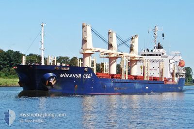
The current position of MINANUR CEBI 1 is in North Atlantic Ocean with coordinates 60.22170° / -6.24305° as reported on 2024-05-21 14:41 by AIS to our vessel tracker app. The vessel's current speed is 1.1 Knopen
The vessel MINANUR CEBI 1 (IMO: 9480564, MMSI: 255806283) is a Bulk Carrier that was built in 2011 ( 13 Jaar oud ). It's sailing under the flag of [PT] Portugal.
In this page you can find informations about the vessels current position, last detected port calls, and current voyage information. If the vessels is not in coverage by AIS you will find the latest position.
The current position of MINANUR CEBI 1 is detected by our AIS receivers and we are not responsible for the reliability of the data. The last position was recorded while the vessel was in Coverage by the Ais receivers of our vessel tracking app.
The current draught of MINANUR CEBI 1 as reported by AIS is 6.6 meters
Weather
| Temperature | 11.3°C / 52.34°F |
|---|---|
| Wind Speed | 6 knots |
| Direction | 330° NNW |
| Pressure | 1011.1 hPa |
| Humidity | 96.9 % |
| Cloud Coverage | 99 % |
Featured Company
Last Port Calls
| Port | Arrival | Departure | Time In Port |
|---|---|---|---|
| 2024-05-01 00:58 | 2024-05-09 11:38 | 8 d | |
| 2024-04-13 16:48 | 2024-04-13 17:00 | 12 m | |
| 2024-04-13 03:48 | 2024-04-13 03:56 | 8 m | |
| 2024-04-10 04:59 | 2024-04-12 21:56 | 2 d | |
| 2024-04-02 08:51 | 2024-04-04 14:17 | 2 d | |
| 2024-03-24 10:58 | 2024-03-31 00:58 | 6 d | |
| 2024-03-03 20:11 |
Most Visited Ports (Last year)
| Port | Arrivals | |
|---|---|---|
| 2 | ||
| 2 | ||
| 1 | ||
| 1 | ||
| 1 | ||
| 1 |
Last Trips
| Origin | Departure | Destination | Arrival | Distance | |
|---|---|---|---|---|---|
| 2024-04-13 17:00 | 2024-05-01 00:58 | 4398.78 nm | |||
| 2024-04-13 03:56 | 2024-04-13 16:48 | 6.31 nm | |||
| 2024-04-12 21:56 | 2024-04-13 03:48 | 38.60 nm | |||
| 2024-04-04 14:17 | 2024-04-10 04:59 | 1248.32 nm | |||
| 2024-03-31 00:58 | 2024-04-02 08:51 | 508.38 nm | |||
| 2024-02-20 02:41 | 2024-03-03 20:11 | 467.65 nm |
Events
| Tijd | Evenement | Details | Positie / Bestemming | Info |
|---|---|---|---|---|
| 2024-05-21 14:47 | Status Changed | Default Under way using engine |
60.22051 / -6.24503
ORDER
|
Snelheid: 1.1 kn Koers: 227° |
| 2024-05-21 14:41 | Buitenbereik |
60.22170 / -6.24305
North Atlantic Ocean
|
Snelheid: 1.1 kn Koers: 196.8° |
|
| 2024-05-21 14:26 | Wijzig zee gebeid | United Kingdom part of the North Atlantic Ocean Faeroe Islands part of the North Atlantic Ocean |
60.22464 / -6.23758
North Atlantic Ocean
|
Snelheid: 0.8 kn Koers: 222° |
| 2024-05-21 14:24 | Status Changed | Under way using engine Default |
60.22487 / -6.23714
ORDER
|
Snelheid: 0.9 kn Koers: 222° |
| 2024-05-21 13:47 | Status Changed | Default Under way using engine |
60.23119 / -6.22284
ORDER
|
Snelheid: 0.8 kn Koers: 230° |
| 2024-05-21 13:41 | Status Changed | Under way using engine Default |
60.23203 / -6.22095
ORDER
|
Snelheid: 0.9 kn Koers: 229° |
| 2024-05-21 13:27 | Status Changed | Default Under way using engine |
60.23405 / -6.21701
ORDER
|
Snelheid: 0.6 kn Koers: 226° |
| 2024-05-21 11:52 | Status Changed | Under way using engine Default |
60.24663 / -6.19158
ORDER
|
Snelheid: 0.7 kn Koers: 243° |
| 2024-05-21 11:35 | Status Changed | Default Under way using engine |
60.24896 / -6.18700
ORDER
|
Snelheid: 0.8 kn Koers: 249° |
| 2024-05-21 05:36 | Wijzig zee gebeid | Faeroe Islands part of the North Atlantic Ocean United Kingdom part of the North Atlantic Ocean |
60.23278 / -6.17952
North Atlantic Ocean
|
Snelheid: 1.1 kn Koers: 27.7° |