
MICK
Cargo A
Current Trip
| Time Travelled | 5 days |
|---|---|
| Remaining Time | --- |
| Distance Travelled | 1746.47 nm |
| Remaining Distance | --- |
| AVG Speed | 13.1 Knopen |
| MAX Speed | 17.1 Knopen |
| AVG Wind | 15 knots |
| MAX Wind | 23.9 knots |
| MIN Temp | 4.5°C / 40.1°F |
| MAX Temp | 18.7°C / 65.66°F |
| Diepgang | 6.5 M |
| Positie ontvangen | 1 m geleden |
Current Position
| Lengtegraad | -17.11084° |
|---|---|
| Breedtegraat | 29.22431° |
| Status | Under way using engine |
| Snelheid | 15.2 Knopen |
| Koers | 202.7° |
| Gebied | North Atlantic Ocean |
| Station | T-AIS |
| Positie ontvangen | 1 m geleden |
Info
Information
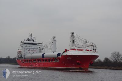
The current position of MICK is in North Atlantic Ocean with coordinates 29.22431° / -17.11084° as reported on 2024-04-30 07:08 by AIS to our vessel tracker app. The vessel's current speed is 15.2 Knopen and is heading at the port of CAPE TOWN. The estimated time of arrival as calculated by MyShipTracking vessel tracking app is 2024-05-13 16:00 LT
The vessel MICK (IMO: 9736183, MMSI: 304342000) is a Cargo A It's sailing under the flag of [AG] Antigua Barbuda.
In this page you can find informations about the vessels current position, last detected port calls, and current voyage information. If the vessels is not in coverage by AIS you will find the latest position.
The current position of MICK is detected by our AIS receivers and we are not responsible for the reliability of the data. The last position was recorded while the vessel was in Coverage by the Ais receivers of our vessel tracking app.
The current draught of MICK as reported by AIS is 6.5 meters
Weather
| Temperature | 18.5°C / 65.3°F |
|---|---|
| Wind Speed | 16 knots |
| Direction | 48° NE |
| Pressure | 1024.8 hPa |
| Humidity | 63.2 % |
| Cloud Coverage | --- |
Featured Company
Last Port Calls
| Port | Arrival | Departure | Time In Port |
|---|---|---|---|
| 2024-04-24 11:40 | 2024-04-25 03:00 | 15 h | |
| 2024-04-21 16:21 | 2024-04-23 16:01 | 1 d | |
| 2024-04-20 18:09 | 2024-04-20 19:24 | 1 h | |
| 2024-04-17 00:23 | 2024-04-19 16:25 | 2 d | |
| 2024-03-08 15:40 | 2024-04-16 19:57 | ||
| 2024-03-05 01:36 | 2024-03-05 22:35 | 20 h | |
| 2024-02-09 00:52 | 2024-02-12 20:16 | 3 d | |
| 2024-02-06 18:40 | 2024-02-07 20:40 | 1 d |
Last Trips
| Origin | Departure | Destination | Arrival | Distance | |
|---|---|---|---|---|---|
| 2024-04-23 18:01 | 2024-04-24 13:40 | 235.96 nm | |||
| 2024-04-20 21:24 | 2024-04-21 18:21 | 205.63 nm | |||
| 2024-04-19 18:25 | 2024-04-20 20:09 | 357.06 nm | |||
| 2024-04-16 21:57 | 2024-04-17 02:23 | 29.29 nm | |||
| 2024-03-05 23:35 | 2024-03-08 16:40 | 627.23 nm | |||
| 2024-02-12 14:16 | 2024-03-05 02:36 | 5803.65 nm | |||
| 2024-02-07 14:40 | 2024-02-08 18:52 | 347.88 nm | |||
| 2024-01-14 12:40 | 2024-02-06 12:40 | 7655.71 nm |
Events
| Tijd | Evenement | Details | Positie / Bestemming | Info |
|---|---|---|---|---|
| 2024-04-30 06:12 | Destination Changed | ZACPT AUDRW |
29.44207 / -17.00900
ZACPT
|
Snelheid: 15.3 kn Koers: 204.5° |
| 2024-04-30 06:12 | ETA Changed | 2024/05/13 16:00 2024/06/01 08:00 |
29.44207 / -17.00900
ZACPT
|
Snelheid: 15.3 kn Koers: 204.5° |
| 2024-04-30 06:01 | Wijzig zee gebeid | Spanish (Canary Islands) part of the North Atlantic Ocean Portuguese (Madeira) part of the North Atlantic Ocean |
29.48636 / -16.98688
North Atlantic Ocean
|
Snelheid: 15.3 kn Koers: 202.8° |
| 2024-04-30 05:44 | Status Changed | Under way using engine Default |
29.55009 / -16.95466
AUDRW
|
Snelheid: 15.1 kn Koers: 205° |
| 2024-04-30 05:42 | Status Changed | Default Under way using engine |
29.56013 / -16.94963
AUDRW
|
Snelheid: 15.1 kn Koers: 204.4° |
| 2024-04-30 05:18 | Wijzig zee gebeid | Portuguese (Madeira) part of the North Atlantic Ocean Spanish part of the North Atlantic Ocean |
29.65403 / -16.90307
North Atlantic Ocean
|
Snelheid: 15.3 kn Koers: 204.7° |
| 2024-04-30 05:18 | Status Changed | Under way using engine Default |
29.65403 / -16.90307
AUDRW
|
Snelheid: 15 kn Koers: 202° |
| 2024-04-30 05:06 | Binnenbereik |
29.65403 / -16.90307
North Atlantic Ocean
|
Snelheid: 15.3 kn Koers: 204.7° |
|
| 2024-04-27 16:50 | Status Changed | Default Under way using engine |
43.77433 / -9.72820
AUDRW
|
Snelheid: 13.9 kn Koers: 208.8° |
| 2024-04-27 16:41 | Buitenbereik |
43.80436 / -9.70734
North Atlantic Ocean
|
Snelheid: 13.9 kn Koers: 208.8° |