

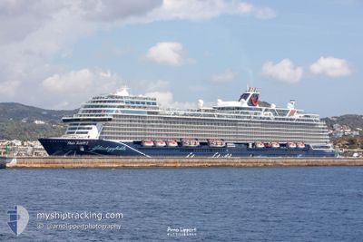
MEIN SCHIFF 2
Passenger

Current Trip
| Trip Time | 15 h, 44 mins |
|---|---|
| Trip Distance | 125.29 nm |
| AVG Speed | 8 Knopen |
| MAX Speed | 9.9 Knopen |
| Diepgang | 8.2 M |
| AVG Wind | 17.2 knots |
| MAX Wind | 21 knots |
| MIN Temp | 24.8°C / 76.64°F |
| MAX Temp | 27.1°C / 80.78°F |
| Positie ontvangen | Nu |
Current Position
| Lengtegraad | --- |
|---|---|
| Breedtegraat | --- |
| Status | Moored |
| Snelheid | |
| Koers | 270° |
| Gebied | Caribbean Sea |
| Station | T-AIS |
| Positie ontvangen | Nu |
Information
The current position of MEIN SCHIFF 2 is in Caribbean Sea with coordinates 17.12150° / -61.84965° as reported on 2025-02-17 17:42 by AIS to our vessel tracker app. The vessel's current speed is 0 Knopen and is currently inside the port of ST JOHNS.
The vessel MEIN SCHIFF 2 (IMO: 9783576, MMSI: 248956000) is a Passenger It's sailing under the flag of [MT] Malta.
In this page you can find informations about the vessels current position, last detected port calls, and current voyage information. If the vessels is not in coverage by AIS you will find the latest position.
The current position of MEIN SCHIFF 2 is detected by our AIS receivers and we are not responsible for the reliability of the data. The last position was recorded while the vessel was in Coverage by the Ais receivers of our vessel tracking app.
The current draught of MEIN SCHIFF 2 as reported by AIS is 8.2 meters
Weather
| Temperature | 26.6°C / 79.88°F |
|---|---|
| Wind Speed | 17 knots |
| Direction | 80° E |
| Pressure | 1017.5 hPa |
| Humidity | 67.4 % |
| Cloud Coverage | 4 % |


Featured Company
Last Port Calls
| Port | Arrival | Departure | Time In Port |
|---|---|---|---|
| 2025-02-17 02:01 | |||
| 2025-02-15 10:37 | 2025-02-16 10:17 | 23 h | |
| 2025-02-14 10:39 | 2025-02-15 00:15 | 13 h | |
| 2025-02-13 10:54 | 2025-02-13 23:05 | 12 h | |
| 2025-02-10 10:32 | 2025-02-12 00:14 | 1 d | |
| 2025-02-09 10:59 | 2025-02-09 23:05 | 12 h | |
| 2025-02-07 10:27 | 2025-02-08 02:16 | 15 h | |
| 2025-02-05 09:28 | 2025-02-06 02:01 | 16 h | |
| 2025-02-04 11:04 | 2025-02-05 02:10 | 15 h | |
| 2025-02-03 11:00 | 2025-02-03 23:15 | 12 h |
Most Visited Ports (Last year)
| Port | Arrivals | |
|---|---|---|
| 20 | ||
| 17 | ||
| 13 | ||
| 11 | ||
| 9 | ||
| 8 |
Last Trips
| Origin | Departure | Destination | Arrival | Distance | |
|---|---|---|---|---|---|
| 2025-02-16 06:17 | 2025-02-16 22:01 | 125.29 nm | |||
| 2025-02-14 20:15 | 2025-02-15 06:37 | 89.83 nm | |||
| 2025-02-13 19:05 | 2025-02-14 06:39 | 129.52 nm | |||
| 2025-02-11 20:14 | 2025-02-13 06:54 | 171.00 nm | |||
| 2025-02-09 19:05 | 2025-02-10 06:32 | 125.47 nm | |||
| 2025-02-07 22:16 | 2025-02-09 06:59 | 514.98 nm | |||
| 2025-02-05 22:01 | 2025-02-07 06:27 | 356.11 nm | |||
| 2025-02-04 22:10 | 2025-02-05 05:28 | 55.93 nm | |||
| 2025-02-03 19:15 | 2025-02-04 07:04 | 129.01 nm | |||
| 2025-02-02 19:12 | 2025-02-03 07:00 | 106.51 nm |
Events
| Tijd | Evenement | Details | Positie / Bestemming | Info |
|---|---|---|---|---|
| 2025-02-17 14:58 | Status Changed | Moored Default |
17.12150 / -61.84965
[AG] ST JOHNS
|
Snelheid: Koers: 270° |
| 2025-02-17 14:43 | Status Changed | Default Moored |
17.12150 / -61.84965
[AG] ST JOHNS
|
Snelheid: Koers: 270° |
| 2025-02-17 14:13 | Status Changed | Moored Default |
17.12149 / -61.84964
[AG] ST JOHNS
|
Snelheid: Koers: 270° |
| 2025-02-17 14:10 | Status Changed | Default Moored |
17.12150 / -61.84965
[AG] ST JOHNS
|
Snelheid: Koers: 270° |
| 2025-02-17 02:28 | Status Changed | Moored Under way using engine |
17.12151 / -61.84966
[AG] ST JOHNS
|
Snelheid: 0.1 kn Koers: 269° |
| 2025-02-17 02:27 | Stop beweging |
17.12149 / -61.84970
[AG] ST JOHNS
|
Snelheid: 0.3 kn Koers: 269° |
|
| 2025-02-17 02:01 | Aankomsthaven |
|
17.12686 / -61.86621
[AG] ST JOHNS
|
Snelheid: 7.8 kn Koers: 113.1° |
| 2025-02-17 00:15 | Destination Changed | AG SJO DM RSU |
16.95778 / -61.96307
AG SJO
|
Snelheid: 7.4 kn Koers: 8.7° |
| 2025-02-17 00:15 | ETA Changed | 2025/02/17 01:45 2025/02/15 10:45 |
16.95778 / -61.96307
AG SJO
|
Snelheid: 7.4 kn Koers: 8.7° |
| 2025-02-16 23:30 | Wijzig zee gebeid | Antigua and Barbuda part of the Caribbean Sea Montserrat part of the Caribbean Sea |
16.85943 / -61.97569
Caribbean Sea
|
Snelheid: 7.9 kn Koers: 6.2° |