

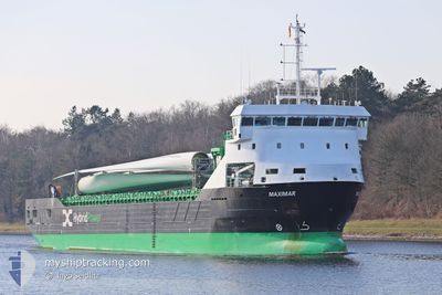
MAXIMAR
Cargo

Current Trip
| Time Travelled | 2 days |
|---|---|
| Remaining Time | 6 h, 29 mins |
| Distance Travelled | 375.90 nm |
| Remaining Distance | 178.51 nm |
| AVG Speed | 6.6 Knopen |
| MAX Speed | 11.4 Knopen |
| AVG Wind | 22.2 knots |
| MAX Wind | 28.8 knots |
| MIN Temp | -0.1°C / 31.82°F |
| MAX Temp | 3°C / 37.4°F |
| Diepgang | 6.1 M |
| Positie ontvangen | 11 h, 45 m geleden |
Current Position
| Lengtegraad | --- |
|---|---|
| Breedtegraat | --- |
| Status | Under way using engine |
| Snelheid | 11.4 Knopen |
| Koers | 29.2° |
| Gebied | Gulf of Bothnia |
| Station | T-AIS |
| Positie ontvangen | 11 h, 45 m geleden |
Information
The current position of MAXIMAR is in Gulf of Bothnia with coordinates 63.50279° / 20.70487° as reported on 2025-03-17 18:14 by AIS to our vessel tracker app. The vessel's current speed is 11.4 Knopen and is heading at the port of ROYTTA. The estimated time of arrival as calculated by MyShipTracking vessel tracking app is 2025-03-18 14:28 LT
The vessel MAXIMAR (IMO: 9951862, MMSI: 210674000) is a Cargo It's sailing under the flag of [CY] Cyprus.
In this page you can find informations about the vessels current position, last detected port calls, and current voyage information. If the vessels is not in coverage by AIS you will find the latest position.
The current position of MAXIMAR is detected by our AIS receivers and we are not responsible for the reliability of the data. The last position was recorded while the vessel was in Coverage by the Ais receivers of our vessel tracking app.
The current draught of MAXIMAR as reported by AIS is 6.1 meters
Weather
| Temperature | 1°C / 33.8°F |
|---|---|
| Wind Speed | 17 knots |
| Direction | 256° WSW |
| Pressure | 1008 hPa |
| Humidity | 93 % |
| Cloud Coverage | 100 % |


Featured Company
Events
| Tijd | Evenement | Details | Positie / Bestemming | Info |
|---|---|---|---|---|
| 2025-03-17 18:14 | Buitenbereik |
63.50279 / 20.70487
Gulf of Bothnia
FITOR
|
Snelheid: 11.4 kn Koers: 29.2° |
|
| 2025-03-17 18:06 | Gevonden in zee | Swedish part of the Gulf of Bothnia |
63.48104 / 20.67656
Gulf of Bothnia
FITOR
|
Snelheid: 11.4 kn Koers: 30.3° |
| 2025-03-17 17:45 | Gevonden in zee | Finnish part of the Gulf of Bothnia |
63.42542 / 20.59575
Gulf of Bothnia
FITOR
|
Snelheid: 11.3 kn Koers: 33.1° |
| 2025-03-17 17:45 | Binnenbereik |
63.42542 / 20.59575
Gulf of Bothnia
FITOR
|
Snelheid: 11.3 kn Koers: 33.1° |
|
| 2025-03-17 01:13 | Buitenbereik |
60.77148 / 19.17917
Gulf of Bothnia
FITOR
|
Snelheid: 9.6 kn Koers: 12.5° |
|
| 2025-03-16 23:51 | Binnenbereik |
60.56192 / 19.08350
Gulf of Bothnia
FITOR
|
Snelheid: 9.4 kn Koers: 11.8° |
|
| 2025-03-16 22:43 | Buitenbereik |
60.40047 / 19.03847
Gulf of Bothnia
FITOR
|
Snelheid: 8.3 kn Koers: 7.9° |
|
| 2025-03-16 21:07 | Wijzig zee gebeid | Swedish part of the Gulf of Bothnia Finnish part of the Gulf of Bothnia |
60.19957 / 19.08000
Gulf of Bothnia
FITOR
|
Snelheid: 8.1 kn Koers: 326° |
| 2025-03-16 16:49 | Wijzig zee gebeid | Finnish part of the Gulf of Bothnia Finnish part of the Baltic Sea |
59.78613 / 19.76714
Gulf of Bothnia
FITOR
|
Snelheid: 2.7 kn Koers: 320.4° |
| 2025-03-16 10:50 | Binnenbereik |
59.59654 / 20.66022
Baltic Sea
FITOR
|
Snelheid: 6.9 kn Koers: 272.8° |