

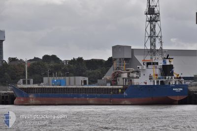
MARATONA
General Cargo

Current Trip
| Time Travelled | 2 days |
|---|---|
| Remaining Time | 1 h, 5 mins |
| Distance Travelled | 660.93 nm |
| Remaining Distance | 32.36 nm |
| AVG Speed | 9.6 Knopen |
| MAX Speed | 12.2 Knopen |
| AVG Wind | 6.1 knots |
| MAX Wind | 22 knots |
| MIN Temp | 6.7°C / 44.06°F |
| MAX Temp | 11.8°C / 53.24°F |
| Diepgang | 3.9 M |
| Positie ontvangen | 11 h, 1 m geleden |
Current Position
| Lengtegraad | --- |
|---|---|
| Breedtegraat | --- |
| Status | Under way using engine |
| Snelheid | 8.9 Knopen |
| Koers | 319.3° |
| Gebied | North Atlantic Ocean |
| Station | T-AIS |
| Positie ontvangen | 11 h, 1 m geleden |
Information
The current position of MARATONA is in North Atlantic Ocean with coordinates 51.58718° / -10.36864° as reported on 2025-03-27 06:26 by AIS to our vessel tracker app. The vessel's current speed is 8.9 Knopen and is heading at the port of LIMERICK. The estimated time of arrival as calculated by MyShipTracking vessel tracking app is 2025-03-27 18:33 LT
The vessel MARATONA (IMO: 9081344, MMSI: 355719000) is a General Cargo that was built in 1993 ( 32 Jaar oud ). It's sailing under the flag of [PA] Panama.
In this page you can find informations about the vessels current position, last detected port calls, and current voyage information. If the vessels is not in coverage by AIS you will find the latest position.
The current position of MARATONA is detected by our AIS receivers and we are not responsible for the reliability of the data. The last position was recorded while the vessel was in Coverage by the Ais receivers of our vessel tracking app.
The current draught of MARATONA as reported by AIS is 3.9 meters
Weather
| Temperature | 9.6°C / 49.28°F |
|---|---|
| Wind Speed | 14 knots |
| Direction | 224° SW |
| Pressure | 1010.9 hPa |
| Humidity | 89.2 % |
| Cloud Coverage | 100 % |


Featured Company
Last Port Calls
| Port | Arrival | Departure | Time In Port |
|---|---|---|---|
| 2025-03-23 08:13 | 2025-03-24 19:04 | 1 d | |
| 2025-03-18 11:15 | 2025-03-20 01:15 | 1 d | |
| 2025-03-16 06:12 | 2025-03-17 07:28 | 1 d | |
| 2025-03-11 16:39 | 2025-03-14 06:15 | 2 d | |
| 2025-03-09 00:39 | 2025-03-10 03:11 | 1 d | |
| 2025-02-28 16:08 | 2025-03-01 20:02 | 1 d | |
| 2025-02-23 05:18 | 2025-02-25 09:00 | 2 d | |
| 2025-02-17 12:12 | 2025-02-20 01:42 | 2 d | |
| 2025-02-12 09:02 | 2025-02-14 12:50 | 2 d | |
| 2025-02-08 07:41 | 2025-02-11 09:46 | 3 d |
Last Trips
| Origin | Departure | Destination | Arrival | Distance | |
|---|---|---|---|---|---|
| 2025-03-20 01:15 | 2025-03-23 08:13 | 627.29 nm | |||
| 2025-03-17 07:28 | 2025-03-18 11:15 | 210.64 nm | |||
| 2025-03-14 06:15 | 2025-03-16 06:12 | 368.09 nm | |||
| 2025-03-10 03:11 | 2025-03-11 16:39 | 354.42 nm | |||
| 2025-03-01 20:02 | 2025-03-09 00:39 | 1004.82 nm | |||
| 2025-02-25 09:00 | 2025-02-28 16:08 | 639.46 nm | |||
| 2025-02-20 01:42 | 2025-02-23 05:18 | 468.48 nm | |||
| 2025-02-14 12:50 | 2025-02-17 12:12 | 473.15 nm | |||
| 2025-02-11 09:46 | 2025-02-12 09:02 | 130.57 nm | |||
| 2025-02-07 06:50 | 2025-02-08 07:41 | 129.55 nm |
Events
| Tijd | Evenement | Details | Positie / Bestemming | Info |
|---|---|---|---|---|
| 2025-03-27 16:02 | Stop beweging | 1.66 nm, South East of CAPPA UPPER |
52.60675 / -9.46836
IELMK
|
Snelheid: 0.3 kn Koers: 244° |
| 2025-03-27 06:26 | Buitenbereik |
51.58718 / -10.36864
North Atlantic Ocean
IELMK
|
Snelheid: 8.9 kn Koers: 319.3° |
|
| 2025-03-27 04:19 | Wijzig zee gebeid | Irish part of the North Atlantic Ocean Irish part of the Celtic Sea |
51.40893 / -9.97634
North Atlantic Ocean
IELMK
|
Snelheid: 9 kn Koers: 307.6° |
| 2025-03-27 02:44 | Binnenbereik |
51.28314 / -9.67759
Celtic Sea
IELMK
|
Snelheid: 8.5 kn Koers: 302.9° |
|
| 2025-03-27 01:00 | Buitenbereik |
51.17754 / -9.32297
Celtic Sea
IELMK
|
Snelheid: 8.7 kn Koers: 293.1° |
|
| 2025-03-26 23:55 | Status Changed | Under way using engine Default |
51.12612 / -9.08159
IELMK
|
Snelheid: 9.2 kn Koers: 285° |
| 2025-03-26 23:46 | Status Changed | Default Under way using engine |
51.11978 / -9.04559
IELMK
|
Snelheid: 9.1 kn Koers: 289.5° |
| 2025-03-26 22:22 | Status Changed | Under way using engine Default |
51.03974 / -8.72605
IELMK
|
Snelheid: 9.6 kn Koers: 294° |
| 2025-03-26 22:14 | Status Changed | Default Under way using engine |
51.03017 / -8.69344
IELMK
|
Snelheid: 9.5 kn Koers: 294.3° |
| 2025-03-26 17:13 | Gevonden in zee | Irish part of the Celtic Sea |
50.73329 / -7.54505
Celtic Sea
IELMK
|
Snelheid: 9.1 kn Koers: 292.7° |