
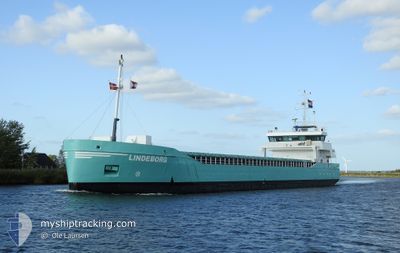
LINDEBORG
General Cargo
Current Trip
| Time Travelled | 16 h, 4 mins |
|---|---|
| Remaining Time | 1 day |
| Distance Travelled | 160.64 nm |
| Remaining Distance | 418.09 nm |
| AVG Speed | 9.5 Knopen |
| MAX Speed | 11.8 Knopen |
| AVG Wind | 18.6 knots |
| MAX Wind | 24.9 knots |
| MIN Temp | 11.6°C / 52.88°F |
| MAX Temp | 15.2°C / 59.36°F |
| Diepgang | 5.7 M |
| Positie ontvangen | Nu |
Current Position
| Lengtegraad | 10.48858° |
|---|---|
| Breedtegraat | 54.54648° |
| Status | Under way using engine |
| Snelheid | 10.1 Knopen |
| Koers | 248° |
| Gebied | Baltic Sea |
| Station | T-AIS |
| Positie ontvangen | Nu |
Info
Information
The current position of LINDEBORG is in Baltic Sea with coordinates 54.54648° / 10.48858° as reported on 2024-05-16 19:59 by AIS to our vessel tracker app. The vessel's current speed is 10.1 Knopen and is heading at the port of NEW HOLLAND. The estimated time of arrival as calculated by MyShipTracking vessel tracking app is 2024-05-18 10:54 LT
The vessel LINDEBORG (IMO: 9279068, MMSI: 246499000) is a General Cargo that was built in 2005 ( 19 Jaar oud ). It's sailing under the flag of [NL] Netherlands.
In this page you can find informations about the vessels current position, last detected port calls, and current voyage information. If the vessels is not in coverage by AIS you will find the latest position.
The current position of LINDEBORG is detected by our AIS receivers and we are not responsible for the reliability of the data. The last position was recorded while the vessel was in Coverage by the Ais receivers of our vessel tracking app.
The current draught of LINDEBORG as reported by AIS is 5.7 meters
Weather
| Temperature | 14.6°C / 58.28°F |
|---|---|
| Wind Speed | 21 knots |
| Direction | 95° E |
| Pressure | 1010.9 hPa |
| Humidity | 81.5 % |
| Cloud Coverage | 10 % |
Featured Company
Last Port Calls
| Port | Arrival | Departure | Time In Port |
|---|---|---|---|
| 2024-05-14 03:50 | 2024-05-16 03:56 | 2 d | |
| 2024-05-10 05:12 | 2024-05-13 18:14 | 3 d | |
| 2024-05-05 04:51 | 2024-05-07 15:13 | 2 d | |
| 2024-04-29 21:14 | 2024-04-30 22:05 | 1 d | |
| 2024-04-23 11:37 | 2024-04-25 01:00 | 1 d | |
| 2024-04-22 23:20 | 2024-04-23 00:13 | 53 m | |
| 2024-04-20 06:40 | 2024-04-22 12:24 | 2 d | |
| 2024-04-17 11:57 | 2024-04-18 11:08 | 23 h | |
| 2024-04-12 15:45 | 2024-04-12 19:45 | 3 h | |
| 2024-04-11 01:40 | 2024-04-11 23:02 | 21 h |
Last Trips
| Origin | Departure | Destination | Arrival | Distance | |
|---|---|---|---|---|---|
| 2024-05-13 20:14 | 2024-05-14 05:50 | 68.67 nm | |||
| 2024-05-07 17:13 | 2024-05-10 07:12 | 581.08 nm | |||
| 2024-04-30 23:05 | 2024-05-05 06:51 | 735.74 nm | |||
| 2024-04-25 03:00 | 2024-04-29 22:14 | 1024.23 nm | |||
| 2024-04-23 02:13 | 2024-04-23 13:37 | 88.33 nm | |||
| 2024-04-22 14:24 | 2024-04-23 01:20 | 105.48 nm | |||
| 2024-04-18 13:08 | 2024-04-20 08:40 | 288.66 nm | |||
| 2024-04-12 21:45 | 2024-04-17 13:57 | 504.63 nm | |||
| 2024-04-12 00:02 | 2024-04-12 17:45 | 185.77 nm | |||
| 2024-04-09 02:40 | 2024-04-11 02:40 | 411.41 nm |
Events
| Tijd | Evenement | Details | Positie / Bestemming | Info |
|---|---|---|---|---|
| 2024-05-16 19:44 | Wijzig zee gebeid | German part of the Baltic Sea Danish part of the Baltic Sea |
54.56214 / 10.55698
Baltic Sea
GBNHO
|
Snelheid: 10.4 kn Koers: 247.6° |
| 2024-05-16 18:53 | Wijzig zee gebeid | Danish part of the Baltic Sea German part of the Baltic Sea |
54.58780 / 10.80237
Baltic Sea
GBNHO
|
Snelheid: 10.2 kn Koers: 260.9° |
| 2024-05-16 17:19 | Wijzig zee gebeid | German part of the Baltic Sea Danish part of the Baltic Sea |
54.57741 / 11.29303
Baltic Sea
GBNHO
|
Snelheid: 11.4 kn Koers: 290.1° |
| 2024-05-16 13:34 | Wijzig zee gebeid | Danish part of the Baltic Sea German part of the Baltic Sea |
54.55122 / 12.27472
Baltic Sea
GBNHO
|
Snelheid: 10.3 kn Koers: 242.8° |
| 2024-05-16 05:16 | Status Changed | Under way using engine Default |
54.20932 / 13.71162
GBNHO
|
Snelheid: 8.9 kn Koers: 339° |
| 2024-05-16 05:09 | Status Changed | Default Under way using engine |
54.19159 / 13.72409
GBNHO
|
Snelheid: 8.3 kn Koers: 272.2° |
| 2024-05-16 04:04 | ETA Changed | 2024/05/19 08:00 2024/05/18 20:00 |
54.07698 / 13.79653
GBNHO
|
Snelheid: 8.6 kn Koers: 1.6° |
| 2024-05-16 03:56 | Vertrekhaven |
|
54.06084 / 13.78711
GBNHO
|
Snelheid: 7 kn Koers: 28° |
| 2024-05-16 03:36 | Binnenbereik |
54.04447 / 13.78040
Baltic Sea
[DE] WOLGAST
|
Snelheid: 4 kn Koers: 42.7° |
|
| 2024-05-15 19:05 | Buitenbereik |
54.03701 / 13.76501
Baltic Sea
[DE] WOLGAST
|
Snelheid: 0.8 kn Koers: 237.2° |