

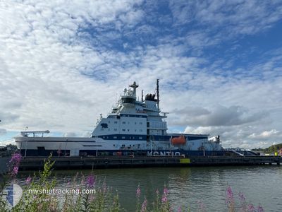
KONTIO
Icebreaker

Current Trip
BAY OF BOTHNIA
| Time Travelled | 3 days |
|---|---|
| Remaining Time | --- |
| Distance Travelled | 362.83 nm |
| Remaining Distance | --- |
| AVG Speed | 10.4 Knopen |
| MAX Speed | 17.8 Knopen |
| AVG Wind | 8.6 knots |
| MAX Wind | 20 knots |
| MIN Temp | -13°C / 8.6°F |
| MAX Temp | 3°C / 37.4°F |
| Diepgang | 7.4 M |
| Positie ontvangen | 2024-12-21 10:54 |
Current Position
| Lengtegraad | --- |
|---|---|
| Breedtegraat | --- |
| Status | Under way using engine |
| Snelheid | 13.3 Knopen |
| Koers | 353.9° |
| Gebied | Gulf of Bothnia |
| Station | T-AIS |
| Positie ontvangen | 2024-12-21 10:54 |
Information
The current position of KONTIO is in Gulf of Bothnia with coordinates 61.33429° / 20.63960° as reported on 2024-12-21 10:54 by AIS to our vessel tracker app. The vessel's current speed is 13.3 Knopen
The vessel KONTIO (IMO: 8518120, MMSI: 230251000) is a Icebreaker that was built in 1987 ( 38 Jaar oud ). It's sailing under the flag of [FI] Finland.
In this page you can find informations about the vessels current position, last detected port calls, and current voyage information. If the vessels is not in coverage by AIS you will find the latest position.
The current position of KONTIO is detected by our AIS receivers and we are not responsible for the reliability of the data. The last position was recorded while the vessel was in Coverage by the Ais receivers of our vessel tracking app.
The current draught of KONTIO as reported by AIS is 7.4 meters
Weather
| Temperature | -2.3°C / 27.86°F |
|---|---|
| Wind Speed | 14 knots |
| Direction | 207° SSW |
| Pressure | 1026.3 hPa |
| Humidity | 87.6 % |
| Cloud Coverage | 38 % |


Featured Company
Last Port Calls
| Port | Arrival | Departure | Time In Port |
|---|---|---|---|
| 2025-03-18 14:30 | 2025-03-18 14:38 | 7 m | |
| 2025-03-18 00:38 | 2025-03-18 00:46 | 7 m | |
| 2025-03-16 06:58 | 2025-03-16 15:10 | 8 h | |
| 2025-03-12 02:34 | 2025-03-12 02:45 | 11 m | |
| 2025-03-10 06:06 | 2025-03-10 06:17 | 11 m | |
| 2025-03-09 14:18 | 2025-03-09 14:26 | 8 m | |
| 2025-03-06 06:46 | 2025-03-06 16:01 | 9 h | |
| 2025-02-25 07:16 | 2025-02-25 16:08 | 8 h | |
| 2025-02-20 00:54 | 2025-02-20 01:12 | 18 m | |
| 2025-02-15 06:53 | 2025-02-15 16:09 | 9 h |
Last Trips
| Origin | Departure | Destination | Arrival | Distance | |
|---|---|---|---|---|---|
| 2025-03-18 00:46 | 2025-03-18 14:30 | 33.15 nm | |||
| 2025-03-16 15:10 | 2025-03-18 00:38 | 205.80 nm | |||
| 2025-03-12 02:45 | 2025-03-16 06:58 | 263.99 nm | |||
| 2025-03-10 06:17 | 2025-03-12 02:34 | 100.35 nm | |||
| 2025-03-09 14:26 | 2025-03-10 06:06 | 73.40 nm | |||
| 2025-03-06 16:01 | 2025-03-09 14:18 | 186.86 nm | |||
| 2025-02-25 16:08 | 2025-03-06 06:46 | 717.70 nm | |||
| 2025-02-20 01:12 | 2025-02-25 07:16 | 813.51 nm | |||
| 2025-02-15 16:09 | 2025-02-20 00:54 | 708.18 nm | |||
| 2025-02-13 10:49 | 2025-02-15 06:53 | 133.76 nm |
Events
| Tijd | Evenement | Details | Positie / Bestemming | Info |
|---|---|---|---|---|
| 2025-03-22 03:06 | Start beweging | 3.01 nm, South of AJOS |
65.61156 / 24.53481
BAY OF BOTHNIA
|
Snelheid: 7.3 kn Koers: 54° |
| 2025-03-22 02:54 | Stop beweging | 3.27 nm, South of AJOS |
65.60632 / 24.51603
BAY OF BOTHNIA
|
Snelheid: Koers: 60° |
| 2025-03-22 02:22 | Start beweging | 6.98 nm, South of AJOS |
65.54908 / 24.43355
BAY OF BOTHNIA
|
Snelheid: 9.7 kn Koers: 35° |
| 2025-03-22 01:38 | Stop beweging | 7.44 nm, South of AJOS |
65.54256 / 24.42233
BAY OF BOTHNIA
|
Snelheid: Koers: 34° |
| 2025-03-21 23:02 | Start beweging |
65.40567 / 23.72453
BAY OF BOTHNIA
|
Snelheid: 10.1 kn Koers: 104° |
|
| 2025-03-21 22:30 | Stop beweging |
65.40786 / 23.70089
BAY OF BOTHNIA
|
Snelheid: 0.3 kn Koers: 90° |
|
| 2025-03-21 21:42 | Start beweging |
65.42026 / 23.51828
BAY OF BOTHNIA
|
Snelheid: 4.8 kn Koers: 98° |
|
| 2025-03-21 21:22 | Stop beweging |
65.42109 / 23.50777
BAY OF BOTHNIA
|
Snelheid: 0.3 kn Koers: 91° |
|
| 2025-03-21 16:14 | Start beweging | 4.17 nm, South of AJOS |
65.59214 / 24.48468
BAY OF BOTHNIA
|
Snelheid: 3.1 kn Koers: 121° |
| 2025-03-21 11:06 | Stop beweging | 4.18 nm, South of AJOS |
65.59265 / 24.47624
BAY OF BOTHNIA
|
Snelheid: Koers: 85° |