

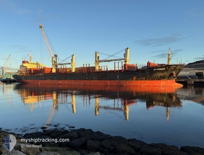
ID PIONEER
Bulk Carrier

Current Trip
| Trip Time | 1 day |
|---|---|
| Trip Distance | 326.21 nm |
| AVG Speed | 9.7 Knopen |
| MAX Speed | 12.8 Knopen |
| Diepgang | 7.8 M |
| AVG Wind | 3.5 knots |
| MAX Wind | 10.8 knots |
| MIN Temp | 10.9°C / 51.62°F |
| MAX Temp | 15°C / 59°F |
| Positie ontvangen | 1 m geleden |
Current Position
| Lengtegraad | --- |
|---|---|
| Breedtegraat | --- |
| Status | Moored |
| Snelheid | 0.1 Knopen |
| Koers | 120° |
| Gebied | Aegean Sea |
| Station | T-AIS |
| Positie ontvangen | 1 m geleden |
Information
The current position of ID PIONEER is in Aegean Sea with coordinates 38.04233° / 23.52867° as reported on 2025-03-02 15:53 by AIS to our vessel tracker app. The vessel's current speed is 0.1 Knopen and is currently inside the port of ELEFSIS.
The vessel ID PIONEER (IMO: 9665700, MMSI: 229969000) is a Bulk Carrier that was built in 2012 ( 13 Jaar oud ). It's sailing under the flag of [MT] Malta.
In this page you can find informations about the vessels current position, last detected port calls, and current voyage information. If the vessels is not in coverage by AIS you will find the latest position.
The current position of ID PIONEER is detected by our AIS receivers and we are not responsible for the reliability of the data. The last position was recorded while the vessel was in Coverage by the Ais receivers of our vessel tracking app.
The current draught of ID PIONEER as reported by AIS is 7.8 meters
Weather
| Temperature | 14°C / 57.2°F |
|---|---|
| Wind Speed | 5 knots |
| Direction | 147° SSE |
| Pressure | 1019.9 hPa |
| Humidity | 74.6 % |
| Cloud Coverage | 100 % |


Featured Company
Most Visited Ports (Last year)
| Port | Arrivals | |
|---|---|---|
| 2 | ||
| 2 | ||
| 2 | ||
| 1 | ||
| 1 | ||
| 1 |
Last Trips
| Origin | Departure | Destination | Arrival | Distance | |
|---|---|---|---|---|---|
| 2025-02-28 10:42 | 2025-03-01 15:06 | 326.21 nm | |||
| 2025-02-03 18:51 | 2025-02-24 08:45 | 2074.17 nm | |||
| 2025-01-25 23:04 | 2025-02-01 21:44 | 951.45 nm | |||
| 2025-01-18 05:26 | 2025-01-23 12:48 | 381.59 nm | |||
| 2024-12-27 10:57 | 2025-01-14 09:01 | 2258.63 nm |
Events
| Tijd | Evenement | Details | Positie / Bestemming | Info |
|---|---|---|---|---|
| 2025-03-01 22:08 | Status Changed | Moored Default |
38.04233 / 23.52867
[GR] ELEFSIS
|
Snelheid: 0.1 kn Koers: 121° |
| 2025-03-01 21:59 | Status Changed | Default Moored |
38.04233 / 23.52867
[GR] ELEFSIS
|
Snelheid: Koers: 121° |
| 2025-03-01 13:32 | Stop beweging |
38.04183 / 23.52817
[GR] ELEFSIS
|
Snelheid: 0.3 kn Koers: 117° |
|
| 2025-03-01 13:29 | Status Changed | Moored Under way using engine |
38.04133 / 23.52800
[GR] ELEFSIS
|
Snelheid: 1.1 kn Koers: 121° |
| 2025-03-01 13:06 | Aankomsthaven |
|
38.03033 / 23.53217
[GR] ELEFSIS
|
Snelheid: 4.3 kn Koers: 333° |
| 2025-03-01 12:29 | Start beweging | 0.39 nm, South West of PERAMA |
37.95467 / 23.56017
GRELE
|
Snelheid: 3.4 kn Koers: 297° |
| 2025-03-01 12:24 | Stop beweging | 0.36 nm, South of PERAMA |
37.95433 / 23.56250
GRELE
|
Snelheid: 0.2 kn Koers: 292° |
| 2025-03-01 11:20 | ETA Changed | 2025/03/01 14:00 2026/01/01 14:00 |
37.90317 / 23.58383
GRELE
|
Snelheid: 2.9 kn Koers: 10° |
| 2025-03-01 11:14 | ETA Changed | 2026/01/01 14:00 2025/03/01 14:00 |
37.89783 / 23.58717
GRELE
|
Snelheid: 4.4 kn Koers: 329° |
| 2025-03-01 11:08 | ETA Changed | 2025/03/01 14:00 2026/01/01 14:00 |
37.89317 / 23.59683
GRELE
|
Snelheid: 6.7 kn Koers: 305° |