
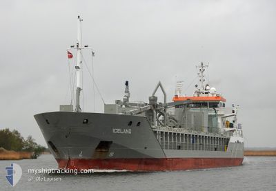
ICELAND
General Cargo
Current Trip
| Time Travelled | 14 h, 35 mins |
|---|---|
| Remaining Time | 15 h, 41 mins |
| Distance Travelled | 186.04 nm |
| Remaining Distance | 208.40 nm |
| AVG Speed | 12.4 Knopen |
| MAX Speed | 13.8 Knopen |
| AVG Wind | 6.2 knots |
| MAX Wind | 11.9 knots |
| MIN Temp | -1.9°C / 28.58°F |
| MAX Temp | 2.8°C / 37.04°F |
| Diepgang | 4.1 M |
| Positie ontvangen | 1 m geleden |
Current Position
| Lengtegraad | --- |
|---|---|
| Breedtegraat | --- |
| Status | Under way using engine |
| Snelheid | 13.2 Knopen |
| Koers | 72.5° |
| Gebied | Kattegat |
| Station | T-AIS |
| Positie ontvangen | 1 m geleden |
Info
Information
The current position of ICELAND is in Kattegat with coordinates 55.48715° / 15.22046° as reported on 2024-11-22 10:08 by AIS to our vessel tracker app. The vessel's current speed is 13.2 Knopen and is heading at the port of LIEPAJA. The estimated time of arrival as calculated by MyShipTracking vessel tracking app is 2024-11-23 03:50 LT
The vessel ICELAND (IMO: 9341782, MMSI: 246546000) is a General Cargo that was built in 2006 ( 18 Jaar oud ). It's sailing under the flag of [NL] Netherlands.
In this page you can find informations about the vessels current position, last detected port calls, and current voyage information. If the vessels is not in coverage by AIS you will find the latest position.
The current position of ICELAND is detected by our AIS receivers and we are not responsible for the reliability of the data. The last position was recorded while the vessel was in Coverage by the Ais receivers of our vessel tracking app.
The current draught of ICELAND as reported by AIS is 4.1 meters
Weather
| Temperature | 2°C / 35.6°F |
|---|---|
| Wind Speed | 8 knots |
| Direction | 308° NW |
| Pressure | 995.2 hPa |
| Humidity | 65.6 % |
| Cloud Coverage | 49 % |
Featured Company
Last Port Calls
| Port | Arrival | Departure | Time In Port |
|---|---|---|---|
| 2024-11-21 11:24 | 2024-11-21 20:34 | 9 h | |
| 2024-11-20 14:36 | 2024-11-21 06:14 | 15 h | |
| 2024-11-18 15:20 | 2024-11-19 11:16 | 19 h | |
| 2024-11-17 16:27 | 2024-11-17 17:20 | 53 m | |
| 2024-11-16 10:00 | 2024-11-17 12:13 | 1 d | |
| 2024-11-16 04:49 | 2024-11-16 05:20 | 31 m | |
| 2024-11-13 14:32 | 2024-11-15 11:28 | 1 d | |
| 2024-11-12 20:34 | 2024-11-12 22:08 | 1 h | |
| 2024-11-11 14:12 | 2024-11-12 15:41 | 1 d | |
| 2024-11-11 09:15 | 2024-11-11 09:38 | 23 m |
Last Trips
| Origin | Departure | Destination | Arrival | Distance | |
|---|---|---|---|---|---|
| 2024-11-21 06:14 | 2024-11-21 11:24 | 56.97 nm | |||
| 2024-11-19 11:16 | 2024-11-20 14:36 | 334.73 nm | |||
| 2024-11-17 17:20 | 2024-11-18 15:20 | 212.73 nm | |||
| 2024-11-17 12:13 | 2024-11-17 16:27 | 48.76 nm | |||
| 2024-11-16 05:20 | 2024-11-16 10:00 | 49.09 nm | |||
| 2024-11-15 11:28 | 2024-11-16 04:49 | 200.72 nm | |||
| 2024-11-12 22:08 | 2024-11-13 14:32 | 196.64 nm | |||
| 2024-11-12 15:41 | 2024-11-12 20:34 | 48.61 nm | |||
| 2024-11-11 09:38 | 2024-11-11 14:12 | 49.11 nm | |||
| 2024-11-10 15:36 | 2024-11-11 09:15 | 202.67 nm |
Events
| Tijd | Evenement | Details | Positie / Bestemming | Info |
|---|---|---|---|---|
| 2024-11-22 07:01 | Wijzig zee gebeid | Danish part of the Kattegat Swedish part of the Baltic Sea |
55.14673 / 14.24090
Kattegat
LVLPX
|
Snelheid: 12.4 kn Koers: 110.1° |
| 2024-11-22 02:47 | Wijzig zee gebeid | Swedish part of the Baltic Sea Danish part of the Baltic Sea |
55.30475 / 12.64185
Baltic Sea
LVLPX
|
Snelheid: 12.8 kn Koers: 159.6° |
| 2024-11-22 02:41 | Wijzig zee gebeid | Danish part of the Baltic Sea Danish part of the Kattegat |
55.32550 / 12.63563
Baltic Sea
LVLPX
|
Snelheid: 12.7 kn Koers: 185.8° |
| 2024-11-22 02:38 | Wijzig zee gebeid | Danish part of the Kattegat Swedish part of the Kattegat |
55.33589 / 12.63817
Kattegat
LVLPX
|
Snelheid: 12.6 kn Koers: 190.3° |
| 2024-11-22 02:02 | Wijzig zee gebeid | Swedish part of the Kattegat Danish part of the Kattegat |
55.46190 / 12.67749
Kattegat
LVLPX
|
Snelheid: 12.9 kn Koers: 190.3° |
| 2024-11-21 22:05 | Wijzig zee gebeid | Danish part of the Kattegat Swedish part of the Kattegat |
56.19412 / 12.40128
Kattegat
LVLPX
|
Snelheid: 13.2 kn Koers: 179.9° |
| 2024-11-21 20:59 | Draught Changed | 4.1 4.4 |
56.41679 / 12.48096
LVLPX
|
Snelheid: 13 kn Koers: 200.1° |
| 2024-11-21 20:59 | Destination Changed | LVLPX SEHAD |
56.41679 / 12.48096
LVLPX
|
Snelheid: 13 kn Koers: 200.1° |
| 2024-11-21 20:03 | Draught Changed | 4.4 4.9 |
56.57541 / 12.71653
SEHAD
|
Snelheid: 13.3 kn Koers: 224.8° |
| 2024-11-21 20:03 | ETA Changed | 2024/11/23 03:00 2024/11/21 11:00 |
56.57541 / 12.71653
SEHAD
|
Snelheid: 13.3 kn Koers: 224.8° |