

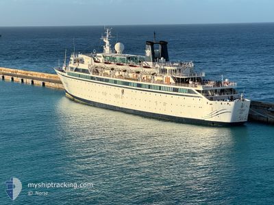
FREEWINDS
Passengers Ship

Current Trip
| Trip Time | 2 days |
|---|---|
| Trip Distance | 165.87 nm |
| AVG Speed | 8.9 Knopen |
| MAX Speed | 8.9 Knopen |
| Diepgang | 6.2 M |
| AVG Wind | 18.3 knots |
| MAX Wind | 23 knots |
| MIN Temp | 24.1°C / 75.38°F |
| MAX Temp | 26.3°C / 79.34°F |
| Positie ontvangen | 5 h, 3 m geleden |
Current Position
| Lengtegraad | --- |
|---|---|
| Breedtegraat | --- |
| Status | Moored |
| Snelheid | |
| Koers | 54° |
| Gebied | Caribbean Sea |
| Station | T-AIS |
| Positie ontvangen | 5 h, 3 m geleden |
Information
The current position of FREEWINDS is in Caribbean Sea with coordinates 14.01417° / -60.99333° as reported on 2025-02-17 12:35 by AIS to our vessel tracker app. The vessel's current speed is 0 Knopen and is currently inside the port of CASTRIES.
The vessel FREEWINDS (IMO: 6810811, MMSI: 354993000) is a Passengers Ship that was built in 1968 ( 57 Jaar oud ). It's sailing under the flag of [PA] Panama.
In this page you can find informations about the vessels current position, last detected port calls, and current voyage information. If the vessels is not in coverage by AIS you will find the latest position.
The current position of FREEWINDS is detected by our AIS receivers and we are not responsible for the reliability of the data. The last position was recorded while the vessel was in Coverage by the Ais receivers of our vessel tracking app.
The current draught of FREEWINDS as reported by AIS is 6.2 meters
Weather
| Temperature | 27.1°C / 80.78°F |
|---|---|
| Wind Speed | 14 knots |
| Direction | 81° E |
| Pressure | 1015.6 hPa |
| Humidity | 63.3 % |
| Cloud Coverage | 5 % |


Featured Company
Last Port Calls
| Port | Arrival | Departure | Time In Port |
|---|---|---|---|
| 2025-02-17 11:56 | |||
| 2025-02-12 11:12 | 2025-02-15 02:47 | 2 d | |
| 2025-02-10 10:19 | 2025-02-12 02:15 | 1 d | |
| 2025-02-04 12:04 | 2025-02-08 02:58 | 3 d | |
| 2025-02-01 12:08 | 2025-02-03 03:04 | 1 d | |
| 2025-01-29 10:53 | 2025-02-01 02:06 | 2 d | |
| 2025-01-29 02:07 | |||
| 2025-01-20 11:11 | 2025-01-22 22:19 | 2 d | |
| 2025-01-18 10:10 | 2025-01-20 09:01 | 1 d | |
| 2025-01-15 10:36 | 2025-01-18 01:51 | 2 d |
Most Visited Ports (Last year)
| Port | Arrivals | |
|---|---|---|
| 25 | ||
| 24 | ||
| 22 | ||
| 3 | ||
| 2 | ||
| 1 |
Last Trips
| Origin | Departure | Destination | Arrival | Distance | |
|---|---|---|---|---|---|
| 2025-02-14 22:47 | 2025-02-17 07:56 | 165.87 nm | |||
| 2025-02-11 22:15 | 2025-02-12 07:12 | 113.98 nm | |||
| 2025-02-07 22:58 | 2025-02-10 06:19 | 162.88 nm | |||
| 2025-02-02 23:04 | 2025-02-04 08:04 | 175.26 nm | |||
| 2025-01-31 22:06 | 2025-02-01 08:08 | 152.74 nm | |||
| 2025-01-28 22:07 | 2025-01-29 06:53 | 114.99 nm | |||
| 2025-01-20 05:01 | 2025-01-20 07:11 | 28.37 nm | |||
| 2025-01-17 21:51 | 2025-01-18 06:10 | 115.52 nm | |||
| 2025-01-12 23:15 | 2025-01-15 06:36 | 162.45 nm | |||
| 2025-01-08 23:26 | 2025-01-09 06:45 | 88.33 nm |
Events
| Tijd | Evenement | Details | Positie / Bestemming | Info |
|---|---|---|---|---|
| 2025-02-17 12:47 | Status Changed | Default Moored |
14.01417 / -60.99317
[LC] CASTRIES
|
Snelheid: Koers: 54° |
| 2025-02-17 12:35 | Status Changed | Moored Default |
14.01417 / -60.99333
[LC] CASTRIES
|
Snelheid: Koers: 54° |
| 2025-02-17 12:35 | Buitenbereik |
14.01417 / -60.99333
Caribbean Sea
[LC] CASTRIES
|
Snelheid: Koers: 346° |
|
| 2025-02-17 12:29 | Status Changed | Default Moored |
14.01417 / -60.99333
[LC] CASTRIES
|
Snelheid: Koers: 55° |
| 2025-02-17 12:26 | Status Changed | Moored Under way using engine |
14.01433 / -60.99333
[LC] CASTRIES
|
Snelheid: Koers: 55° |
| 2025-02-17 12:12 | Stop beweging |
14.01417 / -60.99350
[LC] CASTRIES
|
Snelheid: 0.2 kn Koers: 42° |
|
| 2025-02-17 11:56 | Aankomsthaven |
|
14.01767 / -61.00533
[LC] CASTRIES
|
Snelheid: 6 kn Koers: 121° |
| 2025-02-17 10:59 | Wijzig zee gebeid | Saint Lucia part of the Caribbean Sea Saint Vincent and the Grenadines part of the Caribbean Sea |
13.85833 / -61.10250
Caribbean Sea
|
Snelheid: 14.8 kn Koers: 359° |
| 2025-02-17 10:57 | Status Changed | Under way using engine Default |
13.85067 / -61.10117
KTN SVG
|
Snelheid: 5.7 kn Koers: 331° |
| 2025-02-17 10:41 | Binnenbereik |
13.85833 / -61.10250
Caribbean Sea
|
Snelheid: 14.8 kn Koers: 359° |