
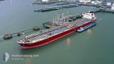
FLAGSHIP TULIP
Oil Products Tanker
Current Trip
ROCND
| Time Travelled | 12 h, 22 mins |
|---|---|
| Remaining Time | --- |
| Distance Travelled | 157.53 nm |
| Remaining Distance | --- |
| AVG Speed | 12.7 Knopen |
| MAX Speed | 14.3 Knopen |
| AVG Wind | 16.1 knots |
| MAX Wind | 38 knots |
| MIN Temp | 6.9°C / 44.42°F |
| MAX Temp | 14.5°C / 58.1°F |
| Diepgang | 10.2 M |
| Positie ontvangen | 12 h, 31 m geleden |
Current Position
| Lengtegraad | --- |
|---|---|
| Breedtegraat | --- |
| Status | Under way using engine |
| Snelheid | 8.2 Knopen |
| Koers | 148° |
| Gebied | Black Sea |
| Station | T-AIS |
| Positie ontvangen | 12 h, 31 m geleden |
Info
Information
The current position of FLAGSHIP TULIP is in Black Sea with coordinates 44.11412° / 28.69254° as reported on 2026-01-03 22:50 by AIS to our vessel tracker app. The vessel's current speed is 8.2 Knopen
The vessel FLAGSHIP TULIP (IMO: 9594896, MMSI: 538006441) is a Oil Products Tanker that was built in 2013 ( 13 Jaar oud ). It's sailing under the flag of [MH] Marshall Is.
In this page you can find informations about the vessels current position, last detected port calls, and current voyage information. If the vessels is not in coverage by AIS you will find the latest position.
The current position of FLAGSHIP TULIP is detected by our AIS receivers and we are not responsible for the reliability of the data. The last position was recorded while the vessel was in Coverage by the Ais receivers of our vessel tracking app.
The current draught of FLAGSHIP TULIP as reported by AIS is 10.2 meters
Weather
| Temperature | 14.6°C / 58.28°F |
|---|---|
| Wind Speed | 37 knots |
| Direction | 215° SW |
| Pressure | 1013.8 hPa |
| Humidity | 70.4 % |
| Cloud Coverage | 45 % |
Featured Company
Last Port Calls
| Port | Arrival | Departure | Time In Port |
|---|---|---|---|
| 2026-01-01 08:20 | 2026-01-04 01:00 | 2 d | |
| 2025-12-14 10:10 | 2025-12-22 14:27 | 8 d | |
| 2025-12-11 09:37 | 2025-12-11 18:57 | 9 h | |
| 2025-11-12 01:28 | 2025-11-13 14:45 | 1 d | |
| 2025-11-08 22:54 | 2025-11-09 23:57 | 1 d |
Last Trips
| Origin | Departure | Destination | Arrival | Distance | |
|---|---|---|---|---|---|
| 2025-12-22 14:27 | 2026-01-01 08:20 | 823.64 nm | |||
| 2025-11-13 14:45 | 2025-12-14 10:10 | 6438.52 nm | |||
| 2025-11-13 14:45 | 2025-12-11 09:37 | 5598.40 nm | |||
| 2025-11-09 23:57 | 2025-11-12 01:28 | 7.27 nm | |||
| 2025-10-22 11:38 | 2025-11-08 22:54 | 3382.93 nm |
Events
| Tijd | Evenement | Details | Positie / Bestemming | Info |
|---|---|---|---|---|
| 2026-01-03 23:00 | Vertrekhaven |
|
44.09325 / 28.70805
ROCND
|
Snelheid: 8.4 kn Koers: 147° |
| 2026-01-03 22:57 | Status Changed | Default Under way using engine |
44.10179 / 28.70276
[RO] CONSTANTA
|
Snelheid: 8.2 kn Koers: 148° |
| 2026-01-03 22:50 | Status Changed | Under way using engine Default |
44.11412 / 28.69254
[RO] CONSTANTA
|
Snelheid: 8 kn Koers: 147° |
| 2026-01-03 22:50 | Buitenbereik |
44.11412 / 28.69254
Black Sea
|
Snelheid: 8.2 kn Koers: 148.6° |
|
| 2026-01-03 22:37 | Start beweging |
44.13885 / 28.67220
[RO] CONSTANTA
|
Snelheid: 5.8 kn Koers: 149° |
|
| 2026-01-03 22:33 | Binnenbereik |
44.11412 / 28.69254
Black Sea
[RO] CONSTANTA
|
Snelheid: 8.2 kn Koers: 148.6° |
|
| 2026-01-01 07:32 | Stop beweging |
44.14188 / 28.66830
[RO] CONSTANTA
|
Snelheid: 0.3 kn Koers: 24° |
|
| 2026-01-01 06:20 | Aankomsthaven |
|
44.10450 / 28.70505
[RO] CONSTANTA
|
Snelheid: 5.6 kn Koers: 341° |
| 2026-01-01 06:08 | Status Changed | Default Under way using engine |
44.08820 / 28.71701
ROCND
|
Snelheid: 5.8 kn Koers: 308.1° |
| 2026-01-01 06:02 | Buitenbereik |
44.08146 / 28.72790
Black Sea
[RO] CONSTANTA
|
Snelheid: 5.8 kn Koers: 308.1° |