
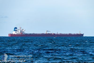
EVREN
Crude Oil Tanker
Current Trip
| Time Travelled | 23 days |
|---|---|
| Remaining Time | --- |
| Distance Travelled | 4674.85 nm |
| Remaining Distance | --- |
| AVG Speed | 11.2 Knopen |
| MAX Speed | 15.6 Knopen |
| AVG Wind | 16.3 knots |
| MAX Wind | 31.8 knots |
| MIN Temp | 9.2°C / 48.56°F |
| MAX Temp | 26.6°C / 79.88°F |
| Diepgang | 8.3 M |
| Positie ontvangen | 8 h, 6 m geleden |
Current Position
| Lengtegraad | --- |
|---|---|
| Breedtegraat | --- |
| Status | At anchor |
| Snelheid | 0.1 Knopen |
| Koers | 178° |
| Gebied | Gulf of Finland |
| Station | T-AIS |
| Positie ontvangen | 8 h, 6 m geleden |
Info
Information
The current position of EVREN is in Gulf of Finland with coordinates 59.77424° / 28.41795° as reported on 2024-10-21 11:04 by AIS to our vessel tracker app. The vessel's current speed is 0.1 Knopen
The vessel EVREN (IMO: 9430313, MMSI: 271051306) is a Crude Oil Tanker that was built in 2010 ( 14 Jaar oud ). It's sailing under the flag of [TR] Turkey.
In this page you can find informations about the vessels current position, last detected port calls, and current voyage information. If the vessels is not in coverage by AIS you will find the latest position.
The current position of EVREN is detected by our AIS receivers and we are not responsible for the reliability of the data. The last position was recorded while the vessel was in Coverage by the Ais receivers of our vessel tracking app.
The current draught of EVREN as reported by AIS is 8.3 meters
Weather
| Temperature | 11°C / 51.8°F |
|---|---|
| Wind Speed | 16 knots |
| Direction | 197° SSW |
| Pressure | 1016.9 hPa |
| Humidity | 49.1 % |
| Cloud Coverage | 100 % |
Featured Company
Most Visited Ports (Last year)
| Port | Arrivals | |
|---|---|---|
| 4 | ||
| 3 | ||
| 2 | ||
| 2 | ||
| 1 |
Events
| Tijd | Evenement | Details | Positie / Bestemming | Info |
|---|---|---|---|---|
| 2024-10-21 11:34 | Status Changed | Default At anchor |
59.77418 / 28.41842
RUULU
|
Snelheid: 0.1 kn Koers: 178° |
| 2024-10-21 11:04 | Buitenbereik |
59.77424 / 28.41795
Gulf of Finland
|
Snelheid: 0.1 kn Koers: 256.7° |
|
| 2024-10-21 09:26 | Status Changed | At anchor Default |
59.77424 / 28.41823
RUULU
|
Snelheid: Koers: 181° |
| 2024-10-21 09:19 | Status Changed | Default At anchor |
59.77422 / 28.41814
RUULU
|
Snelheid: Koers: 178° |
| 2024-10-21 09:13 | Binnenbereik |
59.77422 / 28.41804
Gulf of Finland
|
Snelheid: Koers: 344° |
|
| 2024-10-20 16:42 | Buitenbereik |
59.97487 / 28.53197
Gulf of Finland
|
Snelheid: 1.5 kn Koers: 344° |
|
| 2024-10-20 13:05 | Start beweging | 10.69 nm, North of VISTINO |
59.95024 / 28.56596
RUULU
|
Snelheid: 3.4 kn Koers: 89° |
| 2024-10-20 12:14 | Stop beweging | 9.96 nm, North of VISTINO |
59.94254 / 28.53476
RUULU
|
Snelheid: 0.1 kn Koers: 188° |
| 2024-10-20 04:19 | Draught Changed | 8.3 8.5 |
59.98230 / 26.56998
RUULU
|
Snelheid: 9.6 kn Koers: 75.4° |
| 2024-10-20 03:47 | Gevonden in zee | Russian part of the Gulf of Finland |
59.95999 / 26.42049
Gulf of Finland
RUULU
|
Snelheid: 8.4 kn Koers: 73.9° |