
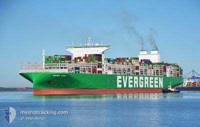
EVER ACE
Cargo D
Current Trip
| Trip Time | 29 days |
|---|---|
| Trip Distance | 12101.85 nm |
| AVG Speed | 14.3 Knopen |
| MAX Speed | 14.3 Knopen |
| Diepgang | 16.4 M |
| AVG Wind | 18.4 knots |
| MAX Wind | 38 knots |
| MIN Temp | 5.8°C / 42.44°F |
| MAX Temp | 29°C / 84.2°F |
| Positie ontvangen | 1 m geleden |
Current Position
| Lengtegraad | --- |
|---|---|
| Breedtegraat | --- |
| Status | Moored |
| Snelheid | |
| Koers | 259° |
| Gebied | North Sea |
| Station | T-AIS |
| Positie ontvangen | 1 m geleden |
Info
Information
The current position of EVER ACE is in North Sea with coordinates 51.94661° / 4.04381° as reported on 2024-12-24 01:56 by AIS to our vessel tracker app. The vessel's current speed is 0 Knopen and is currently inside the port of MAASVLAKTE - ROTTERDAM.
The vessel EVER ACE (IMO: 9893890, MMSI: 352986146) is a Cargo D It's sailing under the flag of [PA] Panama.
In this page you can find informations about the vessels current position, last detected port calls, and current voyage information. If the vessels is not in coverage by AIS you will find the latest position.
The current position of EVER ACE is detected by our AIS receivers and we are not responsible for the reliability of the data. The last position was recorded while the vessel was in Coverage by the Ais receivers of our vessel tracking app.
The current draught of EVER ACE as reported by AIS is 16.4 meters
Weather
| Temperature | 7.2°C / 44.96°F |
|---|---|
| Wind Speed | 10 knots |
| Direction | 271° W |
| Pressure | 1023.3 hPa |
| Humidity | 71.8 % |
| Cloud Coverage | 49 % |
Featured Company
Last Port Calls
| Port | Arrival | Departure | Time In Port |
|---|---|---|---|
| 2024-12-23 20:23 | |||
| 2024-11-23 15:12 | 2024-11-24 13:09 | 21 h | |
| 2024-11-17 04:28 | 2024-11-18 07:20 | 1 d | |
| 2024-11-15 04:42 | 2024-11-16 00:15 | 19 h | |
| 2024-11-11 04:28 | 2024-11-12 14:12 | 1 d | |
| 2024-11-08 02:32 | 2024-11-09 11:32 | 1 d | |
| 2024-11-03 22:43 | 2024-11-05 10:56 | 1 d | |
| 2024-10-29 10:40 | 2024-10-30 14:25 | 1 d | |
| 2024-10-24 05:31 | 2024-10-25 17:44 | 1 d |
Last Trips
| Origin | Departure | Destination | Arrival | Distance | |
|---|---|---|---|---|---|
| 2024-11-24 21:09 | 2024-12-23 21:23 | 12101.85 nm | |||
| 2024-11-18 15:20 | 2024-11-23 23:12 | 1540.24 nm | |||
| 2024-11-16 08:15 | 2024-11-17 12:28 | 459.65 nm | |||
| 2024-11-12 22:12 | 2024-11-15 12:42 | 502.06 nm | |||
| 2024-11-09 19:32 | 2024-11-11 12:28 | 452.94 nm | |||
| 2024-11-05 18:56 | 2024-11-08 10:32 | 957.41 nm | |||
| 2024-10-30 22:25 | 2024-11-04 06:43 | 1646.65 nm | |||
| 2024-10-25 23:14 | 2024-10-29 18:40 | 1597.17 nm | |||
| 2024-09-28 21:38 | 2024-10-24 11:01 | 10702.52 nm |
Events
| Tijd | Evenement | Details | Positie / Bestemming | Info |
|---|---|---|---|---|
| 2024-12-23 21:08 | ETA Changed | 2024/12/23 21:01 2024/12/23 16:00 |
51.94642 / 4.04415
[NL] MAASVLAKTE - ROTTERDAM
|
Snelheid: 0.1 kn Koers: 263° |
| 2024-12-23 21:05 | Status Changed | Moored Under way using engine |
51.94642 / 4.04415
[NL] MAASVLAKTE - ROTTERDAM
|
Snelheid: 0.1 kn Koers: 264° |
| 2024-12-23 21:04 | Status Changed | Under way using engine Moored |
51.94627 / 4.04432
[NL] MAASVLAKTE - ROTTERDAM
|
Snelheid: 0.1 kn Koers: 263° |
| 2024-12-23 21:02 | Status Changed | Moored Under way using engine |
51.94629 / 4.04429
[NL] MAASVLAKTE - ROTTERDAM
|
Snelheid: Koers: 264° |
| 2024-12-23 20:59 | Stop beweging |
51.94626 / 4.04463
[NL] MAASVLAKTE - ROTTERDAM
|
Snelheid: 0.3 kn Koers: 264° |
|
| 2024-12-23 20:23 | Aankomsthaven |
|
51.95047 / 4.07797
[NL] MAASVLAKTE - ROTTERDAM
|
Snelheid: 2.7 kn Koers: 240° |
| 2024-12-23 12:50 | Wijzig zee gebeid | Dutch part of the North Sea Belgian part of the North Sea |
51.86581 / 2.56181
North Sea
SG SIN>NL RTM
|
Snelheid: 9.6 kn Koers: 76.5° |
| 2024-12-23 12:44 | Wijzig zee gebeid | Belgian part of the North Sea United Kingdom part of the North Sea |
51.86194 / 2.53753
North Sea
SG SIN>NL RTM
|
Snelheid: 8.5 kn Koers: 75.1° |
| 2024-12-23 10:53 | ETA Changed | 2024/12/23 16:00 2024/12/23 11:00 |
51.91776 / 2.49308
SG SIN>NL RTM
|
Snelheid: 1.8 kn Koers: 248° |
| 2024-12-23 08:52 | Gevonden in zee | United Kingdom part of the North Sea |
51.94882 / 2.59309
North Sea
SG SIN>NL RTM
|
Snelheid: 10 kn Koers: 266.5° |