
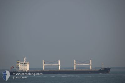
ECO TIDE
Bulk Carrier
Current Trip
| Time Travelled | 8 days |
|---|---|
| Remaining Time | 6 days |
| Distance Travelled | 1951.74 nm |
| Remaining Distance | 2037.42 nm |
| AVG Speed | 11.5 Knopen |
| MAX Speed | 14.4 Knopen |
| AVG Wind | 15.1 knots |
| MAX Wind | 20 knots |
| MIN Temp | 25.5°C / 77.9°F |
| MAX Temp | 28.4°C / 83.12°F |
| Diepgang | 8.2 M |
| Positie ontvangen | 4 d geleden |
Current Position
| Lengtegraad | -61.72331° |
|---|---|
| Breedtegraat | 10.75613° |
| Status | Under way using engine |
| Snelheid | 14.2 Knopen |
| Koers | 49.3° |
| Gebied | Caribbean Sea |
| Station | T-AIS |
| Positie ontvangen | 4 d geleden |
Info
Information
The current position of ECO TIDE is in Caribbean Sea with coordinates 10.75613° / -61.72331° as reported on 2024-06-21 22:50 by AIS to our vessel tracker app. The vessel's current speed is 14.2 Knopen and is heading at the port of GIBRALTAR. The estimated time of arrival as calculated by MyShipTracking vessel tracking app is 2024-07-03 10:31 LT
The vessel ECO TIDE (IMO: 9576739, MMSI: 255806435) is a Bulk Carrier that was built in 2011 ( 13 Jaar oud ). It's sailing under the flag of [PT] Portugal.
In this page you can find informations about the vessels current position, last detected port calls, and current voyage information. If the vessels is not in coverage by AIS you will find the latest position.
The current position of ECO TIDE is detected by our AIS receivers and we are not responsible for the reliability of the data. The last position was recorded while the vessel was in Coverage by the Ais receivers of our vessel tracking app.
The current draught of ECO TIDE as reported by AIS is 8.2 meters
Weather
| Temperature | 25.5°C / 77.9°F |
|---|---|
| Wind Speed | 13 knots |
| Direction | 88° E |
| Pressure | 1020.1 hPa |
| Humidity | 72.8 % |
| Cloud Coverage | 2 % |
Featured Company
Last Port Calls
| Port | Arrival | Departure | Time In Port |
|---|---|---|---|
| 2024-06-03 21:25 | 2024-06-18 03:17 | 14 d | |
| 2024-04-29 18:58 | 2024-05-30 21:07 | ||
| 2024-04-06 19:33 | 2024-04-26 19:01 | 19 d |
Last Trips
| Origin | Departure | Destination | Arrival | Distance | |
|---|---|---|---|---|---|
| 2024-05-30 17:07 | 2024-06-03 17:25 | 782.45 nm | |||
| 2024-04-26 15:01 | 2024-04-29 14:58 | 693.51 nm | |||
| 2024-02-21 17:39 | 2024-04-06 15:33 | 5859.15 nm |
Events
| Tijd | Evenement | Details | Positie / Bestemming | Info |
|---|---|---|---|---|
| 2024-06-21 22:55 | Status Changed | Default Under way using engine |
10.76995 / -61.70680
GIGIB
|
Snelheid: 14.2 kn Koers: 49.3° |
| 2024-06-21 22:50 | Buitenbereik |
10.75613 / -61.72331
Caribbean Sea
GIGIB
|
Snelheid: 14.2 kn Koers: 49.3° |
|
| 2024-06-21 22:46 | Status Changed | Under way using engine Default |
10.74677 / -61.73441
GIGIB
|
Snelheid: 14 kn Koers: 50° |
| 2024-06-21 22:27 | Status Changed | Default Under way using engine |
10.69404 / -61.78722
GIGIB
|
Snelheid: 13.4 kn Koers: 319.7° |
| 2024-06-21 21:42 | Destination Changed | GIGIB TTCHA |
10.64412 / -61.65420
GIGIB
|
Snelheid: 7.3 kn Koers: 271.1° |
| 2024-06-21 21:42 | ETA Changed | 2024/07/02 21:00 2024/06/19 12:00 |
10.64412 / -61.65420
GIGIB
|
Snelheid: 7.3 kn Koers: 271.1° |
| 2024-06-21 21:33 | Start beweging | 1.47 nm, South of CHAGUARAMAS |
10.65067 / -61.65070
TTCHA
|
Snelheid: 3.1 kn Koers: 105° |
| 2024-06-21 21:31 | Status Changed | Under way using engine At anchor |
10.65030 / -61.65225
TTCHA
|
Snelheid: 0.6 kn Koers: 57° |
| 2024-06-21 18:13 | Status Changed | At anchor Default |
10.65064 / -61.64977
TTCHA
|
Snelheid: Koers: 295° |
| 2024-06-21 18:10 | Status Changed | Default At anchor |
10.65061 / -61.64978
TTCHA
|
Snelheid: Koers: 295° |