
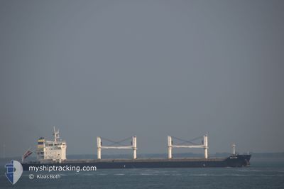
ECO TIDE
Bulk Carrier
Current Trip
| Trip Time | 2 days |
|---|---|
| Trip Distance | 693.51 nm |
| AVG Speed | 11.9 Knots |
| MAX Speed | 14.5 Knots |
| Dybgang | 8.1 m |
| AVG Wind | 16 knots |
| MAX Wind | 24.6 knots |
| MIN Temp | 21.1°C / 69.98°F |
| MAX Temp | 30.6°C / 87.08°F |
| Position Modtaget | 7 d siden |
Current Position
| Longitude | -82.35017° |
|---|---|
| Latitude | 23.12356° |
| Status | Moored |
| Fart | |
| Kurs | 48° |
| Område | North Atlantic Ocean |
| Station | T-AIS |
| Position Modtaget | 7 d siden |
Info
Information
The current position of ECO TIDE is in North Atlantic Ocean with coordinates 23.12356° / -82.35017° as reported on 2024-04-22 16:40 by AIS to our vessel tracker app. The vessel's current speed is 0 Knots and is currently inside the port of SANTIAGO DE CUBA.
The vessel ECO TIDE (IMO: 9576739, MMSI: 255806435) is a Bulk Carrier that was built in 2011 ( 13 år gamle ). It's sailing under the flag of [PT] Portugal.
In this page you can find informations about the vessels current position, last detected port calls, and current voyage information. If the vessels is not in coverage by AIS you will find the latest position.
The current position of ECO TIDE is detected by our AIS receivers and we are not responsible for the reliability of the data. The last position was recorded while the vessel was in Coverage by the Ais receivers of our vessel tracking app.
The current draught of ECO TIDE as reported by AIS is 8.1 meters
Weather
| Temperature | 22.5°C / 72.5°F |
|---|---|
| Wind Speed | 4 knots |
| Direction | 44° NE |
| Pressure | 1014.4 hPa |
| Humidity | 90.5 % |
| Cloud Coverage | 17 % |
Featured Company
Last Port Calls
| Port | Arrival | Departure | Time In Port |
|---|---|---|---|
| 2024-04-29 18:58 | |||
| 2024-04-06 19:33 | 2024-04-26 19:01 | 19 d | |
| 2024-02-04 12:31 | 2024-02-21 14:39 | 17 d |
Events
| Tid | Hændelsen | Detaljer | Position / Dest | Info |
|---|---|---|---|---|
| 2024-04-29 20:05 | STOP Sejllads |
20.02509 / -75.84395
[CU] SANTIAGO DE CUBA
|
Fart: Kurs: 12° |
|
| 2024-04-29 18:58 | Skibe i havn |
|
20.02197 / -75.84164
[CU] SANTIAGO DE CUBA
|
Fart: 7.7 kn Kurs: 34° |
| 2024-04-29 11:09 | START Sejllads | 11.17 nm, South West of HERMANOS DIAZ |
19.89884 / -76.03590
CU HAV
|
Fart: 5.8 kn Kurs: 99° |
| 2024-04-29 02:38 | STOP Sejllads | 6.8 nm, South of HERMANOS DIAZ |
19.88264 / -75.86610
CU HAV
|
Fart: 0.3 kn Kurs: 5° |
| 2024-04-26 19:01 | Afsejlet fra sidste havn |
|
23.15876 / -82.36995
CU HAV
|
Fart: 4 kn Kurs: 305° |
| 2024-04-26 18:51 | START Sejllads |
23.13704 / -82.34042
[CU] HAVANA
|
Fart: 3.5 kn Kurs: 324° |
|
| 2024-04-22 16:49 | Status er ændret | Default Moored |
23.12357 / -82.35017
[CU] HAVANA
|
Fart: Kurs: 48° |
| 2024-04-22 16:40 | Status er ændret | Moored Default |
23.12356 / -82.35017
[CU] HAVANA
|
Fart: Kurs: 48° |
| 2024-04-22 16:40 | Indenfor Dækning |
23.12356 / -82.35017
North Atlantic Ocean
[CU] HAVANA
|
Fart: Kurs: 144.9° |
|
| 2024-04-22 16:40 | Udenfor Dækning |
23.12356 / -82.35017
North Atlantic Ocean
[CU] HAVANA
|
Fart: Kurs: 144.9° |