
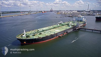
DELTA AMAZON
Tanker
Current Trip
| Time Travelled | 9 days |
|---|---|
| Remaining Time | --- |
| Distance Travelled | 2609.02 nm |
| Remaining Distance | --- |
| AVG Speed | 11.9 Knopen |
| MAX Speed | 22.5 Knopen |
| AVG Wind | 7.7 knots |
| MAX Wind | 19.9 knots |
| MIN Temp | 24.2°C / 75.56°F |
| MAX Temp | 30.5°C / 86.9°F |
| Diepgang | 19.7 M |
| Positie ontvangen | 7 d geleden |
Current Position
| Lengtegraad | 57.25899° |
|---|---|
| Breedtegraat | 24.74904° |
| Status | Under way using engine |
| Snelheid | 13.1 Knopen |
| Koers | 124.3° |
| Gebied | Gulf of Oman |
| Station | T-AIS |
| Positie ontvangen | 7 d geleden |
Info
Information
The current position of DELTA AMAZON is in Gulf of Oman with coordinates 24.74904° / 57.25899° as reported on 2024-04-26 03:00 by AIS to our vessel tracker app. The vessel's current speed is 13.1 Knopen and is heading at the port of QUANZHOU. The estimated time of arrival as calculated by MyShipTracking vessel tracking app is 2024-05-14 16:00 LT
The vessel DELTA AMAZON (IMO: 9748916, MMSI: 636019059) is a Tanker It's sailing under the flag of [LR] Liberia.
In this page you can find informations about the vessels current position, last detected port calls, and current voyage information. If the vessels is not in coverage by AIS you will find the latest position.
The current position of DELTA AMAZON is detected by our AIS receivers and we are not responsible for the reliability of the data. The last position was recorded while the vessel was in Coverage by the Ais receivers of our vessel tracking app.
The current draught of DELTA AMAZON as reported by AIS is 19.7 meters
Weather
| Temperature | 29.7°C / 85.46°F |
|---|---|
| Wind Speed | 6 knots |
| Direction | 169° S |
| Pressure | 1009.6 hPa |
| Humidity | 71.9 % |
| Cloud Coverage | 100 % |
Featured Company
Last Port Calls
| Port | Arrival | Departure | Time In Port |
|---|---|---|---|
| 2024-04-22 09:11 | 2024-04-23 23:23 | 1 d | |
| 2024-03-14 06:59 | 2024-03-18 03:00 | 3 d |
Most Visited Ports (Last year)
| Port | Arrivals | |
|---|---|---|
| 1 | ||
| 1 | ||
| 1 | ||
| 1 |
Last Trips
| Origin | Departure | Destination | Arrival | Distance | |
|---|---|---|---|---|---|
| 2024-03-18 11:00 | 2024-04-22 12:11 | 6231.10 nm |
Events
| Tijd | Evenement | Details | Positie / Bestemming | Info |
|---|---|---|---|---|
| 2024-04-26 03:06 | Status Changed | Default Under way using engine |
24.73668 / 57.27890
CN QZJ
|
Snelheid: 13.1 kn Koers: 124.3° |
| 2024-04-26 03:00 | Buitenbereik |
24.74904 / 57.25899
Gulf of Oman
CN QZJ
|
Snelheid: 13.1 kn Koers: 124.3° |
|
| 2024-04-26 00:34 | Wijzig zee gebeid | Omani part of the Gulf of Oman United Arab Emirates part of the Gulf of Oman |
25.05238 / 56.81500
Gulf of Oman
CN QZJ
|
Snelheid: 12.2 kn Koers: 154.7° |
| 2024-04-25 21:37 | Wijzig zee gebeid | United Arab Emirates part of the Gulf of Oman Omani part of the Gulf of Oman |
25.67187 / 56.74877
Gulf of Oman
CN QZJ
|
Snelheid: 12.8 kn Koers: 182.1° |
| 2024-04-25 20:28 | Gevonden in zee | Omani part of the Gulf of Oman |
25.91388 / 56.73340
Gulf of Oman
CN QZJ
|
Snelheid: 12.3 kn Koers: 177.1° |
| 2024-04-25 20:27 | Status Changed | Under way using engine Default |
25.91788 / 56.73315
CN QZJ
|
Snelheid: 12.3 kn Koers: 178° |
| 2024-04-25 20:27 | Binnenbereik |
25.91388 / 56.73340
Gulf of Oman
CN QZJ
|
Snelheid: 12.3 kn Koers: 177.1° |
|
| 2024-04-25 13:37 | Status Changed | Default Under way using engine |
26.23280 / 55.92768
CN QZJ
|
Snelheid: 3 kn Koers: 60° |
| 2024-04-25 13:31 | Buitenbereik |
26.23016 / 55.92336
Persian Gulf
CN QZJ
|
Snelheid: 3 kn Koers: 56° |
|
| 2024-04-25 13:06 | Start beweging | 13.76 nm, North West of ASH SHAM |
26.21631 / 55.90026
CN QZJ
|
Snelheid: 3.1 kn Koers: 60° |