
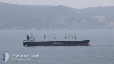
CS CAPRICE
Bulk Carrier
Current Trip
| Trip Time | 30 days |
|---|---|
| Trip Distance | 7173.15 nm |
| AVG Speed | 10.6 Knopen |
| MAX Speed | 16.6 Knopen |
| Diepgang | 10.1 M |
| AVG Wind | 11.9 knots |
| MAX Wind | 33.3 knots |
| MIN Temp | 5.6°C / 42.08°F |
| MAX Temp | 35.6°C / 96.08°F |
| Positie ontvangen | 2 d geleden |
Current Position
| Lengtegraad | --- |
|---|---|
| Breedtegraat | --- |
| Status | Under way using engine |
| Snelheid | 11.1 Knopen |
| Koers | 330.7° |
| Gebied | Aegean Sea |
| Station | T-AIS |
| Positie ontvangen | 2 d geleden |
Info
Information
The current position of CS CAPRICE is in Aegean Sea with coordinates 38.35833° / 24.56618° as reported on 2025-02-03 19:57 by AIS to our vessel tracker app. The vessel's current speed is 11.1 Knopen and is currently inside the port of PSACHNA.
The vessel CS CAPRICE (IMO: 9406104, MMSI: 311016600) is a Bulk Carrier that was built in 2010 ( 15 Jaar oud ). It's sailing under the flag of [BS] Bahamas.
In this page you can find informations about the vessels current position, last detected port calls, and current voyage information. If the vessels is not in coverage by AIS you will find the latest position.
The current position of CS CAPRICE is detected by our AIS receivers and we are not responsible for the reliability of the data. The last position was recorded while the vessel was in Coverage by the Ais receivers of our vessel tracking app.
The current draught of CS CAPRICE as reported by AIS is 10.1 meters
Weather
| Temperature | 5.4°C / 41.72°F |
|---|---|
| Wind Speed | 3 knots |
| Direction | 352° N |
| Pressure | 1032.9 hPa |
| Humidity | 78.7 % |
| Cloud Coverage | 49 % |
Featured Company
Events
| Tijd | Evenement | Details | Positie / Bestemming | Info |
|---|---|---|---|---|
| 2025-02-04 12:31 | Stop beweging |
38.56486 / 23.59781
[GR] PSACHNA
|
Snelheid: Koers: 155° |
|
| 2025-02-04 12:17 | Aankomsthaven |
|
38.56540 / 23.59718
[GR] PSACHNA
|
Snelheid: 2.5 kn Koers: 100° |
| 2025-02-04 12:02 | Start beweging | 0.58 nm, West of PSACHNA |
38.56381 / 23.58700
GR PSA
|
Snelheid: 3.6 kn Koers: 46° |
| 2025-02-04 11:33 | Stop beweging | 0.81 nm, West of PSACHNA |
38.56267 / 23.58230
GR PSA
|
Snelheid: 0.2 kn Koers: 89° |
| 2025-02-03 20:10 | Status Changed | Default Under way using engine |
38.39071 / 24.54206
GR PSA
|
Snelheid: 11.1 kn Koers: 330.7° |
| 2025-02-03 19:57 | Buitenbereik |
38.35833 / 24.56618
Aegean Sea
GR PSA
|
Snelheid: 11.1 kn Koers: 330.7° |
|
| 2025-02-03 15:13 | Status Changed | Under way using engine Default |
37.62066 / 24.21857
GR PSA
|
Snelheid: 11.5 kn Koers: 20° |
| 2025-02-03 14:38 | Status Changed | Default Under way using engine |
37.51099 / 24.16616
GR PSA
|
Snelheid: 11.7 kn Koers: 24.5° |
| 2025-02-03 10:12 | Gevonden in zee | Greek part of the Aegean Sea |
36.81459 / 23.57072
Aegean Sea
GR PSA
|
Snelheid: 11.2 kn Koers: 32.6° |
| 2025-02-03 10:11 | Status Changed | Under way using engine Default |
36.81195 / 23.56859
GR PSA
|
Snelheid: 11.2 kn Koers: 33° |