
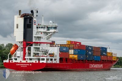
CONTAINERSHIPS 6
Container Ship
Current Trip
| Time Travelled | 2 days |
|---|---|
| Remaining Time | 1 day |
| Distance Travelled | 759.92 nm |
| Remaining Distance | 354.04 nm |
| AVG Speed | 15.5 Knopen |
| MAX Speed | 19.6 Knopen |
| AVG Wind | 16.1 knots |
| MAX Wind | 24 knots |
| MIN Temp | 3.1°C / 37.58°F |
| MAX Temp | 7.1°C / 44.78°F |
| Diepgang | 8.2 M |
| Positie ontvangen | 1 m geleden |
Current Position
| Lengtegraad | --- |
|---|---|
| Breedtegraat | --- |
| Status | Under way using engine |
| Snelheid | 14.8 Knopen |
| Koers | 254° |
| Gebied | Gulf of Finland |
| Station | T-AIS |
| Positie ontvangen | 1 m geleden |
Info
Information
The current position of CONTAINERSHIPS 6 is in Gulf of Finland with coordinates 59.58017° / 22.93867° as reported on 2025-12-09 21:45 by AIS to our vessel tracker app. The vessel's current speed is 14.8 Knopen and is heading at the port of GDANSK. The estimated time of arrival as calculated by MyShipTracking vessel tracking app is 2025-12-10 23:05 LT
The vessel CONTAINERSHIPS 6 (IMO: 9188518, MMSI: 211315100) is a Container Ship that was built in 1999 ( 26 Jaar oud ). It's sailing under the flag of [DE] Germany.
In this page you can find informations about the vessels current position, last detected port calls, and current voyage information. If the vessels is not in coverage by AIS you will find the latest position.
The current position of CONTAINERSHIPS 6 is detected by our AIS receivers and we are not responsible for the reliability of the data. The last position was recorded while the vessel was in Coverage by the Ais receivers of our vessel tracking app.
The current draught of CONTAINERSHIPS 6 as reported by AIS is 8.2 meters
Weather
| Temperature | 5.5°C / 41.9°F |
|---|---|
| Wind Speed | 15 knots |
| Direction | 307° NW |
| Pressure | 1006.7 hPa |
| Humidity | 91.2 % |
| Cloud Coverage | 100 % |
Featured Company
Last Port Calls
| Port | Arrival | Departure | Time In Port |
|---|---|---|---|
| 2025-12-06 03:39 | 2025-12-07 00:55 | 21 h | |
| 2025-12-04 09:51 | 2025-12-05 10:03 | 1 d | |
| 2025-11-27 04:40 | 2025-11-28 13:00 | 1 d | |
| 2025-11-24 06:43 | 2025-11-24 14:28 | 7 h | |
| 2025-11-22 19:56 | 2025-11-23 21:28 | 1 d | |
| 2025-11-19 07:31 | 2025-11-20 01:09 | 17 h | |
| 2025-11-17 20:15 | 2025-11-18 18:53 | 22 h | |
| 2025-11-13 08:47 | 2025-11-15 04:07 | 1 d | |
| 2025-11-09 13:48 | 2025-11-10 23:07 | 1 d | |
| 2025-11-08 09:35 | 2025-11-08 23:03 | 13 h |
Last Trips
| Origin | Departure | Destination | Arrival | Distance | |
|---|---|---|---|---|---|
| 2025-12-05 10:03 | 2025-12-06 03:39 | 251.80 nm | |||
| 2025-11-28 13:00 | 2025-12-04 09:51 | 1643.12 nm | |||
| 2025-11-24 14:28 | 2025-11-27 04:40 | 313.79 nm | |||
| 2025-11-23 21:28 | 2025-11-24 06:43 | 152.41 nm | |||
| 2025-11-20 01:09 | 2025-11-22 19:56 | 540.28 nm | |||
| 2025-11-18 18:53 | 2025-11-19 07:31 | 148.86 nm | |||
| 2025-11-15 04:07 | 2025-11-17 20:15 | 637.72 nm | |||
| 2025-11-10 23:07 | 2025-11-13 08:47 | 807.38 nm | |||
| 2025-11-08 23:03 | 2025-11-09 13:48 | 166.35 nm | |||
| 2025-11-06 08:09 | 2025-11-08 09:35 | 798.82 nm |
Events
| Tijd | Evenement | Details | Positie / Bestemming | Info |
|---|---|---|---|---|
| 2025-12-09 21:29 | Wijzig zee gebeid | Finnish part of the Baltic Sea Finnish part of the Gulf of Finland |
59.59883 / 23.06133
Baltic Sea
PLGDN
|
Snelheid: 14.4 kn Koers: 252° |
| 2025-12-09 19:46 | Status Changed | Under way using engine Default |
59.71433 / 23.85933
PLGDN
|
Snelheid: 14.8 kn Koers: 254° |
| 2025-12-09 19:45 | Status Changed | Default Under way using engine |
59.71533 / 23.86633
PLGDN
|
Snelheid: 14.8 kn Koers: 254° |
| 2025-12-09 19:45 | Status Changed | Under way using engine Default |
59.71550 / 23.86800
PLGDN
|
Snelheid: 14.9 kn Koers: 254° |
| 2025-12-09 19:36 | Status Changed | Default Under way using engine |
59.72567 / 23.93817
PLGDN
|
Snelheid: 14.9 kn Koers: 255° |
| 2025-12-09 17:52 | Wijzig zee gebeid | Finnish part of the Gulf of Finland Estonian part of the Gulf of Finland |
59.82033 / 24.72683
Gulf of Finland
PLGDN
|
Snelheid: 14 kn Koers: 260° |
| 2025-12-09 16:23 | Wijzig zee gebeid | Estonian part of the Gulf of Finland Finnish part of the Gulf of Finland |
59.87783 / 25.41000
Gulf of Finland
PLGDN
|
Snelheid: 14.5 kn Koers: 258° |
| 2025-12-09 14:45 | ETA Changed | 2025/12/10 19:00 2025/12/10 11:00 |
60.00300 / 26.10717
PLGDN
|
Snelheid: 13.9 kn Koers: 233° |
| 2025-12-09 12:08 | Start beweging | 3.77 nm, South of KOTKA |
60.41917 / 26.91917
PLGDN
|
Snelheid: 4 kn Koers: 298° |
| 2025-12-09 11:59 | Status Changed | Under way using engine Moored |
60.42267 / 26.91317
PLGDN
|
Snelheid: Koers: 310° |