
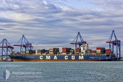
CMA CGM PEGASUS
Container Ship
Current Trip
DEBRV
| Trip Time | 2 days |
|---|---|
| Trip Distance | 495.34 nm |
| AVG Speed | 12.4 Knopen |
| MAX Speed | 12.4 Knopen |
| Diepgang | 12.9 M |
| AVG Wind | 8.4 knots |
| MAX Wind | 13.9 knots |
| MIN Temp | 10.1°C / 50.18°F |
| MAX Temp | 13.7°C / 56.66°F |
| Positie ontvangen | 2 m geleden |
Current Position
| Lengtegraad | 8.53982° |
|---|---|
| Breedtegraat | 53.57327° |
| Status | Moored |
| Snelheid | |
| Koers | 330° |
| Gebied | North Sea |
| Station | T-AIS |
| Positie ontvangen | 2 m geleden |
Info
Information
The current position of CMA CGM PEGASUS is in North Sea with coordinates 53.57327° / 8.53982° as reported on 2024-05-09 02:12 by AIS to our vessel tracker app. The vessel's current speed is 0 Knopen and is currently inside the port of BREMERHAVEN.
The vessel CMA CGM PEGASUS (IMO: 9399210, MMSI: 248013000) is a Container Ship that was built in 2010 ( 14 Jaar oud ). It's sailing under the flag of [MT] Malta.
In this page you can find informations about the vessels current position, last detected port calls, and current voyage information. If the vessels is not in coverage by AIS you will find the latest position.
The current position of CMA CGM PEGASUS is detected by our AIS receivers and we are not responsible for the reliability of the data. The last position was recorded while the vessel was in Coverage by the Ais receivers of our vessel tracking app.
The current draught of CMA CGM PEGASUS as reported by AIS is 13.6 meters
Weather
| Temperature | 9.3°C / 48.74°F |
|---|---|
| Wind Speed | 2 knots |
| Direction | 1° N |
| Pressure | 1027.5 hPa |
| Humidity | 90.7 % |
| Cloud Coverage | 16 % |
Featured Company
Last Port Calls
| Port | Arrival | Departure | Time In Port |
|---|---|---|---|
| 2024-05-08 09:18 | |||
| 2024-05-04 22:10 | 2024-05-06 06:27 | 1 d | |
| 2024-04-30 10:24 | 2024-05-01 00:19 | 13 h | |
| 2024-04-04 22:25 | 2024-04-05 22:35 | 1 d | |
| 2024-04-02 16:45 | 2024-04-03 19:57 | 1 d | |
| 2024-03-28 10:54 | 2024-03-29 03:34 | 16 h | |
| 2024-03-26 07:00 | 2024-03-28 05:11 | 1 d |
Most Visited Ports (Last year)
| Port | Arrivals | |
|---|---|---|
| 8 | ||
| 7 | ||
| 7 | ||
| 5 | ||
| 5 | ||
| 5 |
Last Trips
| Origin | Departure | Destination | Arrival | Distance | |
|---|---|---|---|---|---|
| 2024-05-06 07:27 | 2024-05-08 11:18 | 495.34 nm | |||
| 2024-05-01 01:19 | 2024-05-04 23:10 | 1206.80 nm | |||
| 2024-04-06 04:05 | 2024-04-30 11:24 | 9781.23 nm | |||
| 2024-04-04 01:27 | 2024-04-05 03:55 | 428.86 nm | |||
| 2024-03-29 07:34 | 2024-04-02 22:15 | 1346.55 nm | |||
| 2024-03-28 09:11 | 2024-03-28 14:54 | 47.61 nm | |||
| 2024-02-21 19:45 | 2024-03-26 11:00 | 10005.78 nm |
Events
| Tijd | Evenement | Details | Positie / Bestemming | Info |
|---|---|---|---|---|
| 2024-05-08 15:14 | Destination Changed | DEBRV NLRTM |
53.57328 / 8.53982
[DE] BREMERHAVEN
|
Snelheid: Koers: 330° |
| 2024-05-08 15:14 | ETA Changed | 2024/05/08 06:00 2024/05/10 16:00 |
53.57328 / 8.53982
[DE] BREMERHAVEN
|
Snelheid: Koers: 330° |
| 2024-05-08 15:13 | Draught Changed | 13.6 12.9 |
53.57328 / 8.53982
[DE] BREMERHAVEN
|
Snelheid: Koers: 330° |
| 2024-05-08 15:13 | Destination Changed | NLRTM DEBRV |
53.57328 / 8.53982
[DE] BREMERHAVEN
|
Snelheid: Koers: 330° |
| 2024-05-08 15:13 | ETA Changed | 2024/05/10 16:00 2024/05/08 05:00 |
53.57328 / 8.53982
[DE] BREMERHAVEN
|
Snelheid: Koers: 330° |
| 2024-05-08 10:06 | Status Changed | Moored Under way using engine |
53.57328 / 8.53981
[DE] BREMERHAVEN
|
Snelheid: Koers: 330° |
| 2024-05-08 09:53 | Stop beweging |
53.57300 / 8.53820
[DE] BREMERHAVEN
|
Snelheid: 0.3 kn Koers: 331° |
|
| 2024-05-08 09:18 | Aankomsthaven |
|
53.60351 / 8.50249
[DE] BREMERHAVEN
|
Snelheid: 8.3 kn Koers: 140.3° |
| 2024-05-08 05:04 | Start beweging | 18.29 nm, North of LANGEOOG |
54.02542 / 7.42794
DEBRV
|
Snelheid: 3.5 kn Koers: 86° |
| 2024-05-08 04:58 | Status Changed | Under way using engine Default |
54.02391 / 7.42325
DEBRV
|
Snelheid: 0.3 kn Koers: 48° |