

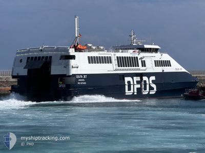
CEUTA JET
High speed craft

Current Trip
| Trip Time | 43 mins |
|---|---|
| Trip Distance | 13.55 nm |
| AVG Speed | 20.8 Knopen |
| MAX Speed | 23 Knopen |
| Diepgang | 2.4 M |
| AVG Wind | 4.9 knots |
| MAX Wind | 6.3 knots |
| MIN Temp | 11.9°C / 53.42°F |
| MAX Temp | 14.2°C / 57.56°F |
| Positie ontvangen | 1 h, 14 m geleden |
Current Position
| Lengtegraad | --- |
|---|---|
| Breedtegraat | --- |
| Status | Under way using engine |
| Snelheid | 15.3 Knopen |
| Koers | 39.8° |
| Gebied | Strait of Gibraltar |
| Station | T-AIS |
| Positie ontvangen | 1 h, 14 m geleden |
Information
The current position of CEUTA JET is in Strait of Gibraltar with coordinates 35.99467° / -5.60708° as reported on 2025-03-27 22:47 by AIS to our vessel tracker app. The vessel's current speed is 15.3 Knopen and is currently inside the port of TARIFA.
The vessel CEUTA JET (IMO: 9174323, MMSI: 212561000) is a High speed craft that was built in 1998 ( 27 Jaar oud ). It's sailing under the flag of [CY] Cyprus.
In this page you can find informations about the vessels current position, last detected port calls, and current voyage information. If the vessels is not in coverage by AIS you will find the latest position.
The current position of CEUTA JET is detected by our AIS receivers and we are not responsible for the reliability of the data. The last position was recorded while the vessel was in Coverage by the Ais receivers of our vessel tracking app.
The current draught of CEUTA JET as reported by AIS is 2.4 meters
Weather
| Temperature | 11.9°C / 53.42°F |
|---|---|
| Wind Speed | 6 knots |
| Direction | 275° W |
| Pressure | 1016.7 hPa |
| Humidity | 83.1 % |
| Cloud Coverage | 62 % |


Featured Company
Last Port Calls
| Port | Arrival | Departure | Time In Port |
|---|---|---|---|
| 2025-03-27 23:55 | |||
| 2025-03-27 20:57 | 2025-03-27 22:12 | 1 h | |
| 2025-03-27 20:04 | 2025-03-27 21:12 | 1 h | |
| 2025-03-27 17:12 | 2025-03-27 18:16 | 1 h | |
| 2025-03-27 16:08 | 2025-03-27 17:28 | 1 h | |
| 2025-03-27 13:02 | 2025-03-27 14:20 | 1 h | |
| 2025-03-27 11:58 | 2025-03-27 13:24 | 1 h | |
| 2025-03-27 09:16 | 2025-03-27 10:16 | 59 m | |
| 2025-03-26 23:48 | 2025-03-27 09:28 | 9 h | |
| 2025-03-26 20:54 | 2025-03-26 21:58 | 1 h |
Last Trips
| Origin | Departure | Destination | Arrival | Distance | |
|---|---|---|---|---|---|
| 2025-03-27 22:12 | 2025-03-27 23:55 | 13.55 nm | |||
| 2025-03-27 21:12 | 2025-03-27 20:57 | 17.40 nm | |||
| 2025-03-27 18:16 | 2025-03-27 20:04 | 15.64 nm | |||
| 2025-03-27 17:28 | 2025-03-27 17:12 | 16.99 nm | |||
| 2025-03-27 14:20 | 2025-03-27 16:08 | 16.75 nm | |||
| 2025-03-27 13:24 | 2025-03-27 13:02 | 16.66 nm | |||
| 2025-03-27 10:16 | 2025-03-27 11:58 | 16.21 nm | |||
| 2025-03-27 09:28 | 2025-03-27 09:16 | 17.06 nm | |||
| 2025-03-26 21:58 | 2025-03-26 23:48 | 16.54 nm | |||
| 2025-03-26 21:16 | 2025-03-26 20:54 | 15.29 nm |
Events
| Tijd | Evenement | Details | Positie / Bestemming | Info |
|---|---|---|---|---|
| 2025-03-27 22:59 | Stop beweging |
36.01017 / -5.60309
[ES] TARIFA
|
Snelheid: Koers: 247° |
|
| 2025-03-27 22:55 | Status Changed | Default Under way using engine |
36.00991 / -5.60309
[ES] TARIFA
|
Snelheid: 15.3 kn Koers: 39.8° |
| 2025-03-27 22:55 | Aankomsthaven |
|
36.00991 / -5.60309
[ES] TARIFA
|
Snelheid: 15.3 kn Koers: 39.8° |
| 2025-03-27 22:47 | Buitenbereik |
35.99467 / -5.60708
Strait of Gibraltar
[ES] TARIFA
|
Snelheid: 15.3 kn Koers: 39.8° |
|
| 2025-03-27 22:47 | ETA Changed | 2025/03/27 23:00 2025/03/27 21:00 |
35.99213 / -5.60997
MATNG-ESTRF-MATNG
|
Snelheid: 20.2 kn Koers: 43.3° |
| 2025-03-27 22:35 | Wijzig zee gebeid | Spanish part of the Strait of Gibraltar Moroccan part of the Strait of Gibraltar |
35.94262 / -5.67637
Strait of Gibraltar
MATNG-ESTRF-MATNG
|
Snelheid: 21.8 kn Koers: 40.6° |
| 2025-03-27 22:21 | Status Changed | Under way using engine Default |
35.88094 / -5.74428
MATNG-ESTRF-MATNG
|
Snelheid: 20.2 kn Koers: 43° |
| 2025-03-27 22:12 | Start beweging | 3.01 nm, North East of TANGIER |
35.83488 / -5.77043
MATNG-ESTRF-MATNG
|
Snelheid: 21.7 kn Koers: 20° |
| 2025-03-27 22:12 | Vertrekhaven |
|
35.83488 / -5.77043
MATNG-ESTRF-MATNG
|
Snelheid: 0.9 kn Koers: 76° |
| 2025-03-27 21:56 | Status Changed | Default Under way using engine |
35.79114 / -5.80224
[MA] TANGIER
|
Snelheid: Koers: 78° |