
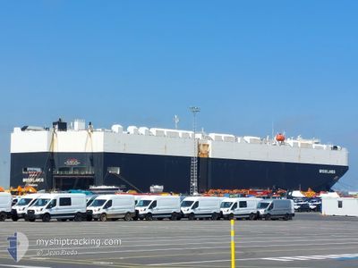
BROOKLANDS
Cargo
Current Trip
| Time Travelled | 8 days |
|---|---|
| Remaining Time | 8 days |
| Distance Travelled | 3033.86 nm |
| Remaining Distance | 3683.06 nm |
| AVG Speed | 14.4 Knopen |
| MAX Speed | 20.1 Knopen |
| AVG Wind | 14.2 knots |
| MAX Wind | 30 knots |
| MIN Temp | 1.8°C / 35.24°F |
| MAX Temp | 21.9°C / 71.42°F |
| Diepgang | 9.3 M |
| Positie ontvangen | 9 m geleden |
Current Position
| Lengtegraad | -18.41910° |
|---|---|
| Breedtegraat | 15.35848° |
| Status | Under way using engine |
| Snelheid | 18 Knopen |
| Koers | 183.4° |
| Gebied | North Atlantic Ocean |
| Station | T-AIS |
| Positie ontvangen | 9 m geleden |
Info
Information
The current position of BROOKLANDS is in North Atlantic Ocean with coordinates 15.35848° / -18.41910° as reported on 2024-04-29 09:54 by AIS to our vessel tracker app. The vessel's current speed is 18 Knopen and is heading at the port of CAPE TOWN. The estimated time of arrival as calculated by MyShipTracking vessel tracking app is 2024-05-08 01:55 LT
The vessel BROOKLANDS (IMO: 9748289, MMSI: 636017767) is a Cargo It's sailing under the flag of [LR] Liberia.
In this page you can find informations about the vessels current position, last detected port calls, and current voyage information. If the vessels is not in coverage by AIS you will find the latest position.
The current position of BROOKLANDS is detected by our AIS receivers and we are not responsible for the reliability of the data. The last position was recorded while the vessel was in Coverage by the Ais receivers of our vessel tracking app.
The current draught of BROOKLANDS as reported by AIS is 9.3 meters
Weather
| Temperature | 21.8°C / 71.24°F |
|---|---|
| Wind Speed | 19 knots |
| Direction | 22° NNE |
| Pressure | 1013.1 hPa |
| Humidity | 85.3 % |
| Cloud Coverage | --- |
Featured Company
Last Port Calls
| Port | Arrival | Departure | Time In Port |
|---|---|---|---|
| 2024-04-19 02:11 | 2024-04-20 15:19 | 1 d | |
| 2024-04-15 18:10 | 2024-04-17 22:52 | 2 d | |
| 2024-04-14 01:16 | 2024-04-14 13:43 | 12 h | |
| 2024-04-02 09:39 | 2024-04-03 18:46 | 1 d | |
| 2024-03-31 06:36 | 2024-04-01 18:29 | 1 d | |
| 2024-03-26 06:06 | 2024-03-29 01:29 | 2 d | |
| 2024-03-25 20:01 | 2024-03-26 05:36 | 9 h | |
| 2024-03-10 01:59 | 2024-03-13 16:07 | 3 d | |
| 2024-03-06 21:14 | 2024-03-08 23:55 | 2 d | |
| 2024-03-01 00:10 | 2024-03-02 16:35 | 1 d |
Most Visited Ports (Last year)
| Port | Arrivals | |
|---|---|---|
| 10 | ||
| 9 | ||
| 9 | ||
| 9 | ||
| 9 | ||
| 9 |
Last Trips
| Origin | Departure | Destination | Arrival | Distance | |
|---|---|---|---|---|---|
| 2024-04-18 00:52 | 2024-04-19 04:11 | 329.81 nm | |||
| 2024-04-14 15:43 | 2024-04-15 20:10 | 161.02 nm | |||
| 2024-04-03 14:46 | 2024-04-14 03:16 | 4089.16 nm | |||
| 2024-04-01 14:29 | 2024-04-02 05:39 | 162.81 nm | |||
| 2024-03-28 21:29 | 2024-03-31 02:36 | 680.36 nm | |||
| 2024-03-26 01:36 | 2024-03-26 02:06 | 0.95 nm | |||
| 2024-03-13 17:07 | 2024-03-25 16:01 | 4199.14 nm | |||
| 2024-03-09 00:55 | 2024-03-10 02:59 | 331.97 nm | |||
| 2024-03-02 16:35 | 2024-03-06 22:14 | 662.60 nm | |||
| 2024-02-15 15:24 | 2024-03-01 00:10 | 3995.01 nm |
Events
| Tijd | Evenement | Details | Positie / Bestemming | Info |
|---|---|---|---|---|
| 2024-04-29 10:02 | Status Changed | Default Under way using engine |
15.31493 / -18.42183
CAPE TOWN
|
Snelheid: 18 kn Koers: 183.4° |
| 2024-04-29 09:39 | Status Changed | Under way using engine Default |
15.43173 / -18.41443
CAPE TOWN
|
Snelheid: 17.9 kn Koers: 183° |
| 2024-04-29 09:38 | Status Changed | Default Under way using engine |
15.43762 / -18.41404
CAPE TOWN
|
Snelheid: 18 kn Koers: 183.5° |
| 2024-04-29 09:18 | Status Changed | Under way using engine Default |
15.53797 / -18.40683
CAPE TOWN
|
Snelheid: 18 kn Koers: 185° |
| 2024-04-29 08:40 | Status Changed | Default Under way using engine |
15.72751 / -18.39283
CAPE TOWN
|
Snelheid: 17.8 kn Koers: 183.4° |
| 2024-04-29 08:36 | Status Changed | Under way using engine Default |
15.74526 / -18.39149
CAPE TOWN
|
Snelheid: 17.8 kn Koers: 182° |
| 2024-04-29 08:12 | Status Changed | Default Under way using engine |
15.86579 / -18.38636
CAPE TOWN
|
Snelheid: 17.6 kn Koers: 182.8° |
| 2024-04-29 07:44 | Status Changed | Under way using engine Default |
16.00041 / -18.37884
CAPE TOWN
|
Snelheid: 17.5 kn Koers: 183° |
| 2024-04-29 07:40 | Status Changed | Default Under way using engine |
16.01997 / -18.37747
CAPE TOWN
|
Snelheid: 17.6 kn Koers: 183.4° |
| 2024-04-29 07:32 | Gevonden in zee | Senegalese part of the North Atlantic Ocean |
16.06290 / -18.37449
North Atlantic Ocean
CAPE TOWN
|
Snelheid: 17.7 kn Koers: 183.8° |