
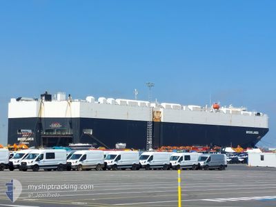
BROOKLANDS
Cargo
Current Trip
| Time Travelled | 12 days |
|---|---|
| Remaining Time | 5 days |
| Distance Travelled | 4517.97 nm |
| Remaining Distance | 2174.13 nm |
| AVG Speed | 15.1 Noeuds |
| MAX Speed | 20.1 Noeuds |
| AVG Wind | 13.3 knots |
| MAX Wind | 30 knots |
| MIN Temp | 1.8°C / 35.24°F |
| MAX Temp | 29.1°C / 84.38°F |
| Tirant d eau | 9.3 m |
| Position reçue | 2 d depuis |
Current Position
| Longitude | -17.41281° |
|---|---|
| Latitude | 11.10147° |
| Etat | Under way using engine |
| Vitesse | 17 Noeuds |
| Parcours | 156.2° |
| Zone | North Atlantic Ocean |
| Station | T-AIS |
| Position reçue | 2 d depuis |
Info
Information
The current position of BROOKLANDS is in North Atlantic Ocean with coordinates 11.10147° / -17.41281° as reported on 2024-04-30 01:17 by AIS to our vessel tracker app. The vessel's current speed is 17 Noeuds and is heading at the port of CAPE TOWN. The estimated time of arrival as calculated by MyShipTracking vessel tracking app is 2024-05-08 08:26 LT
The vessel BROOKLANDS (IMO: 9748289, MMSI: 636017767) is a Cargo It's sailing under the flag of [LR] Liberia.
In this page you can find informations about the vessels current position, last detected port calls, and current voyage information. If the vessels is not in coverage by AIS you will find the latest position.
The current position of BROOKLANDS is detected by our AIS receivers and we are not responsible for the reliability of the data. The last position was recorded while the vessel was in Coverage by the Ais receivers of our vessel tracking app.
The current draught of BROOKLANDS as reported by AIS is 9.3 meters
Weather
| Temperature | 27.4°C / 81.32°F |
|---|---|
| Wind Speed | 9 knots |
| Direction | 136° SE |
| Pressure | 1011.2 hPa |
| Humidity | 71.5 % |
| Cloud Coverage | 100 % |
Featured Company
Last Port Calls
| Port | Arrival | Departure | Time In Port |
|---|---|---|---|
| 2024-04-19 02:11 | 2024-04-20 15:19 | 1 d | |
| 2024-04-15 18:10 | 2024-04-17 22:52 | 2 d | |
| 2024-04-14 01:16 | 2024-04-14 13:43 | 12 h | |
| 2024-04-02 09:39 | 2024-04-03 18:46 | 1 d | |
| 2024-03-31 06:36 | 2024-04-01 18:29 | 1 d | |
| 2024-03-26 06:06 | 2024-03-29 01:29 | 2 d | |
| 2024-03-25 20:01 | 2024-03-26 05:36 | 9 h | |
| 2024-03-10 01:59 | 2024-03-13 16:07 | 3 d | |
| 2024-03-06 21:14 | 2024-03-08 23:55 | 2 d | |
| 2024-03-01 00:10 | 2024-03-02 16:35 | 1 d |
Most Visited Ports (Last year)
| Port | Arrivals | |
|---|---|---|
| 10 | ||
| 9 | ||
| 9 | ||
| 9 | ||
| 9 | ||
| 9 |
Last Trips
| Origin | Departure | Destination | Arrival | Distance | |
|---|---|---|---|---|---|
| 2024-04-18 00:52 | 2024-04-19 04:11 | 329.81 nm | |||
| 2024-04-14 15:43 | 2024-04-15 20:10 | 161.02 nm | |||
| 2024-04-03 14:46 | 2024-04-14 03:16 | 4089.16 nm | |||
| 2024-04-01 14:29 | 2024-04-02 05:39 | 162.81 nm | |||
| 2024-03-28 21:29 | 2024-03-31 02:36 | 680.36 nm | |||
| 2024-03-26 01:36 | 2024-03-26 02:06 | 0.95 nm | |||
| 2024-03-13 17:07 | 2024-03-25 16:01 | 4199.14 nm | |||
| 2024-03-09 00:55 | 2024-03-10 02:59 | 331.97 nm | |||
| 2024-03-02 16:35 | 2024-03-06 22:14 | 662.60 nm | |||
| 2024-02-15 15:24 | 2024-03-01 00:10 | 3995.01 nm |
Events
| Heure | Evenement | Détails | Position/ Destination | Info |
|---|---|---|---|---|
| 2024-04-30 01:36 | Etat Changé | Default Under way using engine |
10.97086 / -17.36465
CAPE TOWN
|
Vitesse: 17 kn Parcours: 156.2° |
| 2024-04-30 01:17 | Hors de la zone couverte |
11.10147 / -17.41281
North Atlantic Ocean
CAPE TOWN
|
Vitesse: 17 kn Parcours: 156.2° |
|
| 2024-04-30 00:30 | Etat Changé | Under way using engine Default |
11.29476 / -17.47080
CAPE TOWN
|
Vitesse: 16.8 kn Parcours: 169° |
| 2024-04-29 23:50 | Etat Changé | Default Under way using engine |
11.45286 / -17.50050
CAPE TOWN
|
Vitesse: 16.9 kn Parcours: 158.5° |
| 2024-04-29 23:35 | Detecté en mer | Guinea Bissau part of the North Atlantic Ocean |
11.51767 / -17.51983
North Atlantic Ocean
CAPE TOWN
|
Vitesse: 16.9 kn Parcours: 160.5° |
| 2024-04-29 23:35 | Etat Changé | Under way using engine Default |
11.51767 / -17.51983
CAPE TOWN
|
Vitesse: 17.1 kn Parcours: 161° |
| 2024-04-29 23:17 | Dans la zone couverte |
11.51767 / -17.51983
North Atlantic Ocean
CAPE TOWN
|
Vitesse: 16.9 kn Parcours: 160.5° |
|
| 2024-04-29 22:26 | Etat Changé | Default Under way using engine |
11.82833 / -17.62343
CAPE TOWN
|
Vitesse: 17.1 kn Parcours: 174° |
| 2024-04-29 22:18 | Hors de la zone couverte |
11.86639 / -17.62783
North Atlantic Ocean
CAPE TOWN
|
Vitesse: 17.1 kn Parcours: 174° |
|
| 2024-04-29 22:09 | Etat Changé | Under way using engine Default |
11.90838 / -17.63341
CAPE TOWN
|
Vitesse: 16.9 kn Parcours: 165° |