

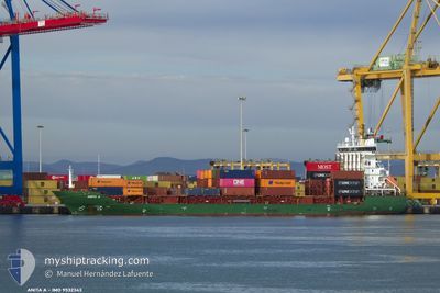
ANITA A
Container Ship

Current Trip
| Time Travelled | 14 h, 7 mins |
|---|---|
| Remaining Time | --- |
| Distance Travelled | 200.22 nm |
| Remaining Distance | --- |
| AVG Speed | 14.2 Knopen |
| MAX Speed | 14.9 Knopen |
| AVG Wind | 12.6 knots |
| MAX Wind | 15.3 knots |
| MIN Temp | 17.7°C / 63.86°F |
| MAX Temp | 18.9°C / 66.02°F |
| Diepgang | 6.7 M |
| Positie ontvangen | 2 m geleden |
Current Position
| Lengtegraad | --- |
|---|---|
| Breedtegraat | --- |
| Status | Under way using engine |
| Snelheid | 14.6 Knopen |
| Koers | 335.7° |
| Gebied | Mediterranean Sea - Eastern Basin |
| Station | T-AIS |
| Positie ontvangen | 2 m geleden |
Information
The current position of ANITA A is in Mediterranean Sea - Eastern Basin with coordinates 34.23204° / 28.27682° as reported on 2025-03-27 14:58 by AIS to our vessel tracker app. The vessel's current speed is 14.6 Knopen and is heading at the port of DILISKELESI. The estimated time of arrival as calculated by MyShipTracking vessel tracking app is 2025-03-28 22:00 LT
The vessel ANITA A (IMO: 9532343, MMSI: 636021307) is a Container Ship that was built in 2009 ( 16 Jaar oud ). It's sailing under the flag of [LR] Liberia.
In this page you can find informations about the vessels current position, last detected port calls, and current voyage information. If the vessels is not in coverage by AIS you will find the latest position.
The current position of ANITA A is detected by our AIS receivers and we are not responsible for the reliability of the data. The last position was recorded while the vessel was in Coverage by the Ais receivers of our vessel tracking app.
The current draught of ANITA A as reported by AIS is 6.7 meters
Weather
| Temperature | 17.8°C / 64.04°F |
|---|---|
| Wind Speed | 14 knots |
| Direction | 131° SE |
| Pressure | 1007.1 hPa |
| Humidity | 85 % |
| Cloud Coverage | 100 % |


Featured Company
Last Port Calls
| Port | Arrival | Departure | Time In Port |
|---|---|---|---|
| 2025-03-26 15:05 | 2025-03-27 02:53 | 11 h | |
| 2025-03-24 22:31 | 2025-03-25 17:23 | 18 h | |
| 2025-03-23 21:55 | 2025-03-24 15:24 | 17 h | |
| 2025-03-20 13:59 | 2025-03-21 07:27 | 17 h | |
| 2025-03-18 00:48 | 2025-03-18 08:10 | 7 h | |
| 2025-03-14 12:45 | 2025-03-16 15:32 | 2 d | |
| 2025-03-12 12:37 | 2025-03-12 21:25 | 8 h | |
| 2025-03-10 09:49 | 2025-03-10 21:05 | 11 h | |
| 2025-03-07 23:20 | 2025-03-09 12:30 | 1 d | |
| 2025-03-06 06:23 | 2025-03-07 17:23 | 1 d |
Most Visited Ports (Last year)
| Port | Arrivals | |
|---|---|---|
| 42 | ||
| 38 | ||
| 23 | ||
| 20 | ||
| 16 | ||
| 9 |
Last Trips
| Origin | Departure | Destination | Arrival | Distance | |
|---|---|---|---|---|---|
| 2025-03-25 17:23 | 2025-03-26 15:05 | 267.16 nm | |||
| 2025-03-24 15:24 | 2025-03-24 22:31 | 83.68 nm | |||
| 2025-03-21 07:27 | 2025-03-23 21:55 | 179.66 nm | |||
| 2025-03-18 08:10 | 2025-03-20 13:59 | 284.15 nm | |||
| 2025-03-16 15:32 | 2025-03-18 00:48 | 13.16 nm | |||
| 2025-03-12 21:25 | 2025-03-14 12:45 | 17.02 nm | |||
| 2025-03-10 21:05 | 2025-03-12 12:37 | 472.26 nm | |||
| 2025-03-09 12:30 | 2025-03-10 09:49 | 255.06 nm | |||
| 2025-03-07 17:23 | 2025-03-07 23:20 | 78.26 nm | |||
| 2025-03-04 14:37 | 2025-03-06 06:23 | 249.52 nm |
Events
| Tijd | Evenement | Details | Positie / Bestemming | Info |
|---|---|---|---|---|
| 2025-03-27 11:27 | Gevonden in zee | Greek part of the Mediterranean Sea - Eastern Basin |
33.46304 / 28.67983
Mediterranean Sea - Eastern Basin
TRDIL
|
Snelheid: 14.3 kn Koers: 338.7° |
| 2025-03-27 06:03 | Destination Changed | TRDIL EGALY |
32.24052 / 29.26921
TRDIL
|
Snelheid: 14.8 kn Koers: 336.9° |
| 2025-03-27 06:03 | ETA Changed | 2025/03/28 19:00 2025/03/29 16:00 |
32.24052 / 29.26921
TRDIL
|
Snelheid: 14.8 kn Koers: 336.9° |
| 2025-03-27 04:01 | Draught Changed | 6.7 7.6 |
31.79419 / 29.50890
EGALY
|
Snelheid: 13.9 kn Koers: 335.5° |
| 2025-03-27 04:01 | ETA Changed | 2025/03/29 16:00 2025/03/26 14:00 |
31.79419 / 29.50890
EGALY
|
Snelheid: 13.9 kn Koers: 335.5° |
| 2025-03-27 03:45 | Status Changed | Under way using engine Default |
31.73925 / 29.53621
EGALY
|
Snelheid: 13.9 kn Koers: 338° |
| 2025-03-27 03:14 | Status Changed | Default Under way using engine |
31.62763 / 29.59175
EGALY
|
Snelheid: 13.9 kn Koers: 336.2° |
| 2025-03-27 02:38 | Status Changed | Under way using engine Default |
31.49858 / 29.65169
EGALY
|
Snelheid: 14.1 kn Koers: 338° |
| 2025-03-27 02:34 | Status Changed | Default Under way using engine |
31.48090 / 29.66058
EGALY
|
Snelheid: 14 kn Koers: 336.6° |
| 2025-03-27 02:23 | Status Changed | Under way using engine Default |
31.44313 / 29.67919
EGALY
|
Snelheid: 14 kn Koers: 336° |