
AMOENITAS
General Cargo
Current Trip
| Time Travelled | 1 day |
|---|---|
| Remaining Time | --- |
| Distance Travelled | 379.27 nm |
| Remaining Distance | 1.47 nm |
| AVG Speed | 9.9 Knopen |
| MAX Speed | 15.5 Knopen |
| AVG Wind | 12.9 knots |
| MAX Wind | 20 knots |
| MIN Temp | 3.2°C / 37.76°F |
| MAX Temp | 12.8°C / 55.04°F |
| Diepgang | 6.5 M |
| Positie ontvangen | 2 m geleden |
Current Position
| Lengtegraad | --- |
|---|---|
| Breedtegraat | --- |
| Status | Moored |
| Snelheid | |
| Koers | 304° |
| Gebied | North Sea |
| Station | T-AIS |
| Positie ontvangen | 2 m geleden |
Info
Information
The current position of AMOENITAS is in North Sea with coordinates 53.84845° / 8.74930° as reported on 2024-12-02 04:36 by AIS to our vessel tracker app. The vessel's current speed is 0 Knopen and is heading at the port of CUXHAVEN. The estimated time of arrival as calculated by MyShipTracking vessel tracking app is 2024-12-01 14:40 LT
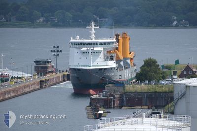
The vessel AMOENITAS (IMO: 9505510, MMSI: 305621000) is a General Cargo that was built in 2010 ( 14 Jaar oud ). It's sailing under the flag of [AG] Antigua Barbuda.
In this page you can find informations about the vessels current position, last detected port calls, and current voyage information. If the vessels is not in coverage by AIS you will find the latest position.
The current position of AMOENITAS is detected by our AIS receivers and we are not responsible for the reliability of the data. The last position was recorded while the vessel was in Coverage by the Ais receivers of our vessel tracking app.
The current draught of AMOENITAS as reported by AIS is 6.5 meters
Weather
| Temperature | 6.3°C / 43.34°F |
|---|---|
| Wind Speed | 13 knots |
| Direction | 202° SSW |
| Pressure | 1012.3 hPa |
| Humidity | 84.4 % |
| Cloud Coverage | 94 % |
Featured Company
Last Port Calls
| Port | Arrival | Departure | Time In Port |
|---|---|---|---|
| 2024-11-28 13:57 | 2024-11-30 12:55 | 1 d | |
| 2024-11-26 22:40 | 2024-11-26 23:50 | 1 h | |
| 2024-11-22 13:08 | 2024-11-25 10:12 | 2 d | |
| 2024-11-16 01:12 | 2024-11-16 01:18 | 6 m | |
| 2024-11-13 09:50 | 2024-11-14 08:57 | 23 h | |
| 2024-10-30 17:18 | 2024-11-04 23:58 | 5 d | |
| 2024-10-26 12:43 | 2024-10-27 17:26 | 1 d | |
| 2024-10-25 13:26 | 2024-10-25 20:31 | 7 h | |
| 2024-10-15 10:55 | 2024-10-19 14:15 | 4 d | |
| 2024-10-01 12:59 |
Last Trips
| Origin | Departure | Destination | Arrival | Distance | |
|---|---|---|---|---|---|
| 2024-11-26 23:50 | 2024-11-28 13:57 | 20.22 nm | |||
| 2024-11-25 11:12 | 2024-11-26 22:40 | 364.45 nm | |||
| 2024-11-16 01:18 | 2024-11-22 14:08 | 1989.70 nm | |||
| 2024-11-14 08:57 | 2024-11-16 01:12 | 63.24 nm | |||
| 2024-11-04 23:58 | 2024-11-13 09:50 | 2096.10 nm | |||
| 2024-10-27 17:26 | 2024-10-30 17:18 | 14.00 nm | |||
| 2024-10-25 20:31 | 2024-10-26 12:43 | 8.53 nm | |||
| 2024-10-19 14:15 | 2024-10-25 13:26 | 19.51 nm | |||
| 2024-10-01 12:59 | 2024-10-15 10:55 | 41.67 nm |
Events
| Tijd | Evenement | Details | Positie / Bestemming | Info |
|---|---|---|---|---|
| 2024-12-02 04:36 | Status Changed | Moored Default |
53.84845 / 8.74930
DECUX
|
Snelheid: Koers: 304° |
| 2024-12-02 04:30 | Status Changed | Default Moored |
53.84844 / 8.74933
DECUX
|
Snelheid: Koers: 304° |
| 2024-12-02 02:18 | Status Changed | Moored Default |
53.84851 / 8.74928
DECUX
|
Snelheid: Koers: 304° |
| 2024-12-02 02:15 | Status Changed | Default Moored |
53.84850 / 8.74933
DECUX
|
Snelheid: Koers: 304° |
| 2024-12-02 02:12 | Status Changed | Moored Default |
53.84850 / 8.74930
DECUX
|
Snelheid: Koers: 304° |
| 2024-12-02 02:06 | Status Changed | Default Moored |
53.84849 / 8.74927
DECUX
|
Snelheid: Koers: 304° |
| 2024-12-02 01:27 | Status Changed | Moored Default |
53.84850 / 8.74924
DECUX
|
Snelheid: Koers: 304° |
| 2024-12-02 01:15 | Status Changed | Default Moored |
53.84851 / 8.74927
DECUX
|
Snelheid: Koers: 304° |
| 2024-12-02 01:12 | Status Changed | Moored Default |
53.84845 / 8.74935
DECUX
|
Snelheid: Koers: 304° |
| 2024-12-02 01:03 | Status Changed | Default Moored |
53.84851 / 8.74923
DECUX
|
Snelheid: Koers: 304° |