
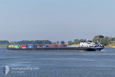
ALORBA
Cargo
Current Trip
| Time Travelled | 1 day |
|---|---|
| Remaining Time | 17 h, 10 mins |
| Distance Travelled | 278.22 nm |
| Remaining Distance | 175.26 nm |
| AVG Speed | 9.5 Knopen |
| MAX Speed | 11.7 Knopen |
| AVG Wind | 7.5 knots |
| MAX Wind | 13 knots |
| MIN Temp | -1.4°C / 29.48°F |
| MAX Temp | 9.5°C / 49.1°F |
| Diepgang | 2.1 M |
| Positie ontvangen | 1 m geleden |
Current Position
| Lengtegraad | --- |
|---|---|
| Breedtegraat | --- |
| Status | Under way using engine |
| Snelheid | 10.6 Knopen |
| Koers | 23.4° |
| Gebied | North Sea |
| Station | T-AIS |
| Positie ontvangen | 1 m geleden |
Info
Information
The current position of ALORBA is in North Sea with coordinates 51.15212° / 6.85604° as reported on 2025-03-16 11:29 by AIS to our vessel tracker app. The vessel's current speed is 10.6 Knopen and is heading at the port of ANTWERP. The estimated time of arrival as calculated by MyShipTracking vessel tracking app is 2025-03-17 05:40 LT
The vessel ALORBA (MMSI: 244890610) is a Cargo It's sailing under the flag of [NL] Netherlands.
In this page you can find informations about the vessels current position, last detected port calls, and current voyage information. If the vessels is not in coverage by AIS you will find the latest position.
The current position of ALORBA is detected by our AIS receivers and we are not responsible for the reliability of the data. The last position was recorded while the vessel was in Coverage by the Ais receivers of our vessel tracking app.
The current draught of ALORBA as reported by AIS is 2.1 meters
Weather
| Temperature | 8.1°C / 46.58°F |
|---|---|
| Wind Speed | 8 knots |
| Direction | 35° NE |
| Pressure | 1021.6 hPa |
| Humidity | 49 % |
| Cloud Coverage | 6 % |
Featured Company
Last Port Calls
| Port | Arrival | Departure | Time In Port |
|---|---|---|---|
| 2025-03-13 19:21 | 2025-03-14 16:43 | 21 h | |
| 2025-03-13 18:44 | 2025-03-13 19:07 | 22 m | |
| 2025-03-13 11:58 | 2025-03-13 18:02 | 6 h | |
| 2025-03-13 10:21 | 2025-03-13 10:47 | 25 m | |
| 2025-03-13 09:33 | 2025-03-13 10:18 | 45 m | |
| 2025-03-11 02:38 | 2025-03-11 11:12 | 8 h | |
| 2025-03-08 22:40 | 2025-03-09 07:32 | 8 h | |
| 2025-03-08 15:17 | 2025-03-08 16:07 | 49 m | |
| 2025-03-07 13:24 | 2025-03-08 11:48 | 22 h | |
| 2025-03-07 11:14 | 2025-03-07 13:17 | 2 h |
Most Visited Ports (Last year)
| Port | Arrivals | |
|---|---|---|
| 84 | ||
| 51 | ||
| 32 | ||
| 28 | ||
| 25 | ||
| 24 |
Last Trips
| Origin | Departure | Destination | Arrival | Distance | |
|---|---|---|---|---|---|
| 2025-03-13 19:07 | 2025-03-13 19:21 | 0.94 nm | |||
| 2025-03-13 18:02 | 2025-03-13 18:44 | 1.65 nm | |||
| 2025-03-13 10:47 | 2025-03-13 11:58 | 2.24 nm | |||
| 2025-03-13 10:18 | 2025-03-13 10:21 | 0.66 nm | |||
| 2025-03-11 11:12 | 2025-03-13 09:33 | 147.21 nm | |||
| 2025-03-09 07:32 | 2025-03-11 02:38 | 214.22 nm | |||
| 2025-03-08 16:07 | 2025-03-08 22:40 | 44.96 nm | |||
| 2025-03-08 11:48 | 2025-03-08 15:17 | 27.04 nm | |||
| 2025-03-07 13:17 | 2025-03-07 13:24 | 1.11 nm | |||
| 2025-03-07 10:35 | 2025-03-07 11:14 | 3.15 nm |
Events
| Tijd | Evenement | Details | Positie / Bestemming | Info |
|---|---|---|---|---|
| 2025-03-16 06:02 | Binnenbereik |
50.45910 / 7.36419
North Sea
ANVERS
|
Snelheid: 10.3 kn Koers: 312° |
|
| 2025-03-16 01:23 | Buitenbereik |
49.98065 / 7.86714
North Sea
ANVERS
|
Snelheid: 9.7 kn Koers: 328.1° |
|
| 2025-03-15 12:27 | Draught Changed | 2.1 1.7 |
48.78840 / 8.05914
ANVERS
|
Snelheid: 8.3 kn Koers: 95.3° |
| 2025-03-15 12:27 | Destination Changed | ANVERS BASEL |
48.78840 / 8.05914
ANVERS
|
Snelheid: 8.3 kn Koers: 95.3° |
| 2025-03-15 12:27 | ETA Changed | 2025/03/17 10:00 2025/03/13 00:00 |
48.78840 / 8.05914
ANVERS
|
Snelheid: 8.3 kn Koers: 95.3° |
| 2025-03-15 11:58 | Binnenbereik |
48.75837 / 8.00640
North Sea
|
Snelheid: 8.3 kn Koers: 85.9° |
|
| 2025-03-14 19:23 | Buitenbereik |
47.81018 / 7.54058
North Sea
|
Snelheid: 8.8 kn Koers: 23.3° |
|
| 2025-03-14 19:06 | Start beweging | 10.78 nm, North of HUNINGUE |
47.77376 / 7.52516
BASEL
|
Snelheid: 6.9 kn Koers: 355.6° |
| 2025-03-14 19:03 | Status Changed | Under way using engine Moored |
47.76924 / 7.52601
BASEL
|
Snelheid: Koers: 511° |
| 2025-03-14 18:36 | Status Changed | Moored Under way using engine |
47.76791 / 7.52636
BASEL
|
Snelheid: 0.4 kn Koers: 511° |