
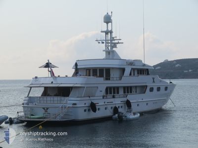
X CHIOS
Yacht
Current Trip
| Time Travelled | 1 day |
|---|---|
| Remaining Time | --- |
| Distance Travelled | 30.03 nm |
| Remaining Distance | --- |
| AVG Speed | 10.5 Noeuds |
| MAX Speed | 13.3 Noeuds |
| AVG Wind | 8.7 knots |
| MAX Wind | 9 knots |
| MIN Temp | 23°C / 73.4°F |
| MAX Temp | 28°C / 82.4°F |
| Tirant d eau | 3.5 m |
| Position reçue | 4 m depuis |
Current Position
| Longitude | 23.76133° |
|---|---|
| Latitude | 37.80799° |
| Etat | At anchor |
| Vitesse | |
| Parcours | --- |
| Zone | Aegean Sea |
| Station | T-AIS |
| Position reçue | 4 m depuis |
Info
Information
The current position of X CHIOS is in Aegean Sea with coordinates 37.80799° / 23.76133° as reported on 2024-06-03 13:24 by AIS to our vessel tracker app. The vessel's current speed is 0 Noeuds
The vessel X CHIOS (IMO: 1003736, MMSI: 235088564) is a Yacht that was built in 1987 ( 37 Age ). It's sailing under the flag of [GB] United Kingdom.
In this page you can find informations about the vessels current position, last detected port calls, and current voyage information. If the vessels is not in coverage by AIS you will find the latest position.
The current position of X CHIOS is detected by our AIS receivers and we are not responsible for the reliability of the data. The last position was recorded while the vessel was in Coverage by the Ais receivers of our vessel tracking app.
The current draught of X CHIOS as reported by AIS is 3.5 meters
Weather
| Temperature | 25.7°C / 78.26°F |
|---|---|
| Wind Speed | 7 knots |
| Direction | 157° SSE |
| Pressure | 1013.4 hPa |
| Humidity | 55.5 % |
| Cloud Coverage | 100 % |
Featured Company
Last Port Calls
| Port | Arrival | Departure | Time In Port |
|---|---|---|---|
| 2024-05-31 18:41 | 2024-06-02 13:56 | 1 d | |
| 2024-05-31 17:34 | |||
| 2024-05-19 19:51 | 2024-05-24 14:29 | 4 d | |
| 2024-05-07 17:52 | 2024-05-17 14:23 | 9 d | |
| 2024-05-06 14:57 | 2024-05-07 13:06 | 22 h | |
| 2024-04-27 17:23 | 2024-05-06 13:10 | 8 d | |
| 2024-04-22 11:07 | 2024-04-27 13:18 | 5 d | |
| 2024-04-22 10:08 |
Last Trips
| Origin | Departure | Destination | Arrival | Distance | |
|---|---|---|---|---|---|
| 2024-05-31 17:34 | 2024-05-31 18:41 | 14.56 nm | |||
| 2024-05-17 14:23 | 2024-05-19 19:51 | 43.58 nm | |||
| 2024-05-07 13:06 | 2024-05-07 17:52 | 37.32 nm | |||
| 2024-05-06 13:10 | 2024-05-06 14:57 | 13.19 nm | |||
| 2024-04-27 13:18 | 2024-04-27 17:23 | 48.14 nm | |||
| 2024-04-22 10:08 | 2024-04-22 11:07 | 11.11 nm |
Events
| Heure | Evenement | Détails | Position/ Destination | Info |
|---|---|---|---|---|
| 2024-06-02 13:36 | Etat Changé | At anchor Under way using engine |
37.80799 / 23.76133
VOULIAGMENI
|
Vitesse: Parcours: 511° |
| 2024-06-02 13:31 | Arret | 0.64 nm, North West of VOULIAGMENI |
37.80799 / 23.76133
VOULIAGMENI
|
Vitesse: Parcours: 511° |
| 2024-06-02 13:19 | Changement de destination | VOULIAGMENI TZIA |
37.78795 / 23.77039
VOULIAGMENI
|
Vitesse: 12.8 kn Parcours: 311.5° |
| 2024-06-02 13:19 | Changement d'ETA | 2024/06/02 16:30 2025/05/31 18:30 |
37.78795 / 23.77039
VOULIAGMENI
|
Vitesse: 12.8 kn Parcours: 311.5° |
| 2024-06-02 11:05 | Dans la zone couverte |
37.66376 / 24.28166
Aegean Sea
|
Vitesse: 13 kn Parcours: 265° |
|
| 2024-06-02 10:56 | PORT DE DEPART |
|
37.66376 / 24.28166
TZIA
|
Vitesse: Parcours: 511° |
| 2024-06-02 09:34 | Hors de la zone couverte |
37.66677 / 24.32286
Aegean Sea
[GR] KEA
|
Vitesse: Parcours: 0° |
|
| 2024-06-01 14:19 | Dans la zone couverte |
37.66677 / 24.32286
Aegean Sea
[GR] KEA
|
Vitesse: Parcours: 0° |
|
| 2024-06-01 12:37 | Hors de la zone couverte |
37.66677 / 24.32286
Aegean Sea
[GR] KEA
|
Vitesse: Parcours: 0° |
|
| 2024-06-01 02:13 | Dans la zone couverte |
37.66677 / 24.32286
Aegean Sea
[GR] KEA
|
Vitesse: Parcours: 0° |