

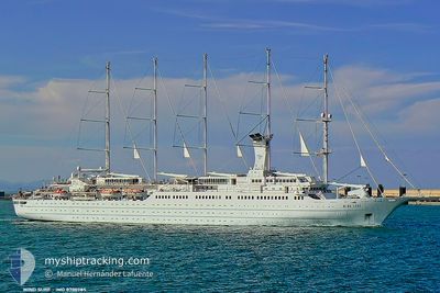
WIND SURF
Passengers Ship

Current Trip
VG PRICKLY PEAR
| Time Travelled | 5 days |
|---|---|
| Remaining Time | --- |
| Distance Travelled | 446.49 nm |
| Remaining Distance | --- |
| AVG Speed | 7.1 Noeuds |
| MAX Speed | 11.5 Noeuds |
| AVG Wind | 17.5 knots |
| MAX Wind | 22 knots |
| MIN Temp | 25.4°C / 77.72°F |
| MAX Temp | 27.6°C / 81.68°F |
| Tirant d eau | 5.4 m |
| Position reçue | 3 m depuis |
Current Position
| Longitude | --- |
|---|---|
| Latitude | --- |
| Etat | Under way using engine |
| Vitesse | 6.8 Noeuds |
| Parcours | 110° |
| Zone | Caribbean Sea |
| Station | T-AIS |
| Position reçue | 3 m depuis |
Information
The current position of WIND SURF is in Caribbean Sea with coordinates 18.04309° / -63.41571° as reported on 2025-03-28 06:49 by AIS to our vessel tracker app. The vessel's current speed is 6.8 Noeuds
The vessel WIND SURF (IMO: 8700785, MMSI: 309242000) is a Passengers Ship that was built in 1989 ( 36 Age ). It's sailing under the flag of [BS] Bahamas.
In this page you can find informations about the vessels current position, last detected port calls, and current voyage information. If the vessels is not in coverage by AIS you will find the latest position.
The current position of WIND SURF is detected by our AIS receivers and we are not responsible for the reliability of the data. The last position was recorded while the vessel was in Coverage by the Ais receivers of our vessel tracking app.
The current draught of WIND SURF as reported by AIS is 5.4 meters
Weather
| Temperature | 26.2°C / 79.16°F |
|---|---|
| Wind Speed | 15 knots |
| Direction | 93° E |
| Pressure | 1015.2 hPa |
| Humidity | 70.8 % |
| Cloud Coverage | 48 % |


Featured Company
Last Port Calls
| Port | Arrival | Departure | Time In Port |
|---|---|---|---|
| 2025-03-22 09:43 | 2025-03-22 22:50 | 13 h | |
| 2025-03-20 11:12 | 2025-03-21 01:57 | 14 h | |
| 2025-03-18 11:31 | 2025-03-18 20:55 | 9 h | |
| 2025-03-17 11:26 | 2025-03-17 22:05 | 10 h | |
| 2025-03-15 09:38 | 2025-03-15 23:05 | 13 h | |
| 2025-03-08 09:44 | 2025-03-08 23:54 | 14 h | |
| 2025-03-01 09:44 | 2025-03-01 23:28 | 13 h | |
| 2025-02-25 20:47 | 2025-02-25 20:55 | 7 m | |
| 2025-02-24 11:19 | 2025-02-24 21:09 | 9 h | |
| 2025-02-22 09:45 | 2025-02-22 23:30 | 13 h |
Most Visited Ports (Last year)
| Port | Arrivals | |
|---|---|---|
| 15 | ||
| 11 | ||
| 9 | ||
| 7 | ||
| 7 | ||
| 6 |
Last Trips
| Origin | Departure | Destination | Arrival | Distance | |
|---|---|---|---|---|---|
| 2025-03-20 21:57 | 2025-03-22 05:43 | 85.15 nm | |||
| 2025-03-18 16:55 | 2025-03-20 07:12 | 231.67 nm | |||
| 2025-03-17 18:05 | 2025-03-18 07:31 | 83.78 nm | |||
| 2025-03-15 19:05 | 2025-03-17 07:26 | 200.57 nm | |||
| 2025-03-08 19:54 | 2025-03-15 05:38 | 515.29 nm | |||
| 2025-03-01 19:28 | 2025-03-08 05:44 | 513.02 nm | |||
| 2025-02-25 16:55 | 2025-03-01 05:44 | 332.74 nm | |||
| 2025-02-24 17:09 | 2025-02-25 16:47 | 86.25 nm | |||
| 2025-02-22 19:30 | 2025-02-24 07:19 | 199.92 nm | |||
| 2025-02-15 19:00 | 2025-02-22 05:45 | 647.58 nm |
Events
| Heure | Evenement | Détails | Position/ Destination | Info |
|---|---|---|---|---|
| 2025-03-28 06:45 | Changement de zone | Saint-Martin part of the Caribbean Sea Anguilla part of the Caribbean Sea |
18.04631 / -63.42325
Caribbean Sea
|
Vitesse: 6.8 kn Parcours: 120.5° |
| 2025-03-28 06:39 | Etat Changé | Under way using engine Default |
18.05186 / -63.43326
VG PRICKLY PEAR
|
Vitesse: 6.7 kn Parcours: 128° |
| 2025-03-28 05:45 | Etat Changé | Default Under way using engine |
18.10759 / -63.52072
VG PRICKLY PEAR
|
Vitesse: 6 kn Parcours: 115° |
| 2025-03-28 05:42 | Etat Changé | Under way using engine Default |
18.11002 / -63.52568
VG PRICKLY PEAR
|
Vitesse: 6.6 kn Parcours: 118° |
| 2025-03-28 05:27 | Etat Changé | Default Under way using engine |
18.12230 / -63.55132
VG PRICKLY PEAR
|
Vitesse: 6 kn Parcours: 115° |
| 2025-03-28 02:54 | Detecté en mer | Anguilla part of the Caribbean Sea |
18.24904 / -63.81475
Caribbean Sea
|
Vitesse: 6 kn Parcours: 116° |
| 2025-03-28 02:54 | Etat Changé | Under way using engine Default |
18.24904 / -63.81475
VG PRICKLY PEAR
|
Vitesse: 6.6 kn Parcours: 116° |
| 2025-03-28 02:54 | Dans la zone couverte |
18.24904 / -63.81475
Caribbean Sea
|
Vitesse: 6 kn Parcours: 116° |
|
| 2025-03-27 23:09 | Etat Changé | Default Under way using engine |
18.43871 / -64.20407
VG PRICKLY PEAR
|
Vitesse: 6.8 kn Parcours: 117.2° |
| 2025-03-27 22:56 | Hors de la zone couverte |
18.45049 / -64.22708
Caribbean Sea
|
Vitesse: 6.8 kn Parcours: 117.2° |