
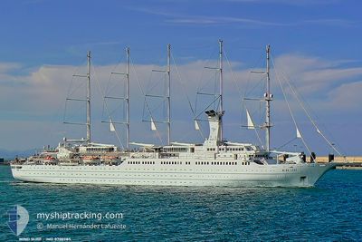
WIND SURF
Passengers Ship
Current Trip
| Time Travelled | 1 day |
|---|---|
| Remaining Time | 3 h, 27 mins |
| Distance Travelled | 202.78 nm |
| Remaining Distance | 42.05 nm |
| AVG Speed | 8.5 Knopen |
| MAX Speed | 9.5 Knopen |
| AVG Wind | 15.5 knots |
| MAX Wind | 17 knots |
| MIN Temp | 24.8°C / 76.64°F |
| MAX Temp | 26.7°C / 80.06°F |
| Diepgang | 5.4 M |
| Positie ontvangen | 1 h, 40 m geleden |
Current Position
| Lengtegraad | --- |
|---|---|
| Breedtegraat | --- |
| Status | Under way using engine |
| Snelheid | 8 Knopen |
| Koers | 328° |
| Gebied | Caribbean Sea |
| Station | T-AIS |
| Positie ontvangen | 1 h, 40 m geleden |
Info
Information
The current position of WIND SURF is in Caribbean Sea with coordinates 16.65294° / -62.39642° as reported on 2025-02-27 05:57 by AIS to our vessel tracker app. The vessel's current speed is 8 Knopen and is heading at the port of BASSETERRE. The estimated time of arrival as calculated by MyShipTracking vessel tracking app is 2025-02-27 11:05 LT
The vessel WIND SURF (IMO: 8700785, MMSI: 309242000) is a Passengers Ship that was built in 1989 ( 36 Jaar oud ). It's sailing under the flag of [BS] Bahamas.
In this page you can find informations about the vessels current position, last detected port calls, and current voyage information. If the vessels is not in coverage by AIS you will find the latest position.
The current position of WIND SURF is detected by our AIS receivers and we are not responsible for the reliability of the data. The last position was recorded while the vessel was in Coverage by the Ais receivers of our vessel tracking app.
The current draught of WIND SURF as reported by AIS is 5.4 meters
Weather
| Temperature | 25.7°C / 78.26°F |
|---|---|
| Wind Speed | 16 knots |
| Direction | 83° E |
| Pressure | 1014.7 hPa |
| Humidity | 76.8 % |
| Cloud Coverage | --- |
Featured Company
Last Port Calls
| Port | Arrival | Departure | Time In Port |
|---|---|---|---|
| 2025-02-25 20:47 | 2025-02-25 20:55 | 7 m | |
| 2025-02-24 11:19 | 2025-02-24 21:09 | 9 h | |
| 2025-02-22 09:45 | 2025-02-22 23:30 | 13 h | |
| 2025-02-15 09:44 | 2025-02-15 23:00 | 13 h | |
| 2025-02-11 20:35 | 2025-02-11 21:04 | 29 m | |
| 2025-02-11 10:59 | 2025-02-11 19:26 | 8 h | |
| 2025-02-10 11:21 | 2025-02-10 21:17 | 9 h | |
| 2025-02-08 09:45 | 2025-02-09 00:20 | 14 h | |
| 2025-02-01 12:25 | 2025-02-01 23:26 | 11 h | |
| 2025-01-25 09:59 | 2025-01-25 23:36 | 13 h |
Most Visited Ports (Last year)
| Port | Arrivals | |
|---|---|---|
| 15 | ||
| 11 | ||
| 9 | ||
| 7 | ||
| 7 | ||
| 7 |
Last Trips
| Origin | Departure | Destination | Arrival | Distance | |
|---|---|---|---|---|---|
| 2025-02-24 17:09 | 2025-02-25 16:47 | 86.25 nm | |||
| 2025-02-22 19:30 | 2025-02-24 07:19 | 199.92 nm | |||
| 2025-02-15 19:00 | 2025-02-22 05:45 | 647.58 nm | |||
| 2025-02-11 17:04 | 2025-02-15 05:44 | 331.80 nm | |||
| 2025-02-11 15:26 | 2025-02-11 16:35 | 0.29 nm | |||
| 2025-02-10 17:17 | 2025-02-11 06:59 | 84.69 nm | |||
| 2025-02-08 20:20 | 2025-02-10 07:21 | 201.41 nm | |||
| 2025-02-01 19:26 | 2025-02-08 05:45 | 519.40 nm | |||
| 2025-01-25 19:36 | 2025-02-01 08:25 | 538.63 nm | |||
| 2025-01-21 15:39 | 2025-01-25 05:59 | 366.02 nm |
Events
| Tijd | Evenement | Details | Positie / Bestemming | Info |
|---|---|---|---|---|
| 2025-02-27 06:03 | Status Changed | Default Under way using engine |
16.66497 / -62.40410
BASSETERRE
|
Snelheid: 8 kn Koers: 328° |
| 2025-02-27 05:57 | Buitenbereik |
16.65294 / -62.39642
Caribbean Sea
BASSETERRE
|
Snelheid: 8 kn Koers: 328° |
|
| 2025-02-27 05:50 | Status Changed | Under way using engine Default |
16.63885 / -62.38745
BASSETERRE
|
Snelheid: 8.4 kn Koers: 328° |
| 2025-02-27 05:34 | Status Changed | Default Under way using engine |
16.60700 / -62.36704
BASSETERRE
|
Snelheid: 8 kn Koers: 327° |
| 2025-02-27 05:28 | Status Changed | Under way using engine Default |
16.59476 / -62.35918
BASSETERRE
|
Snelheid: 8.6 kn Koers: 328° |
| 2025-02-27 05:25 | Status Changed | Default Under way using engine |
16.58753 / -62.35441
BASSETERRE
|
Snelheid: 8 kn Koers: 327° |
| 2025-02-27 05:18 | Status Changed | Under way using engine Default |
16.57356 / -62.34516
BASSETERRE
|
Snelheid: 8.5 kn Koers: 332° |
| 2025-02-27 05:13 | Status Changed | Default Under way using engine |
16.56378 / -62.33893
BASSETERRE
|
Snelheid: 8 kn Koers: 339° |
| 2025-02-27 05:09 | Status Changed | Under way using engine Default |
16.55579 / -62.33494
BASSETERRE
|
Snelheid: 8.5 kn Koers: 341° |
| 2025-02-27 04:52 | Status Changed | Default Under way using engine |
16.51796 / -62.32193
BASSETERRE
|
Snelheid: 8.3 kn Koers: 332.3° |