
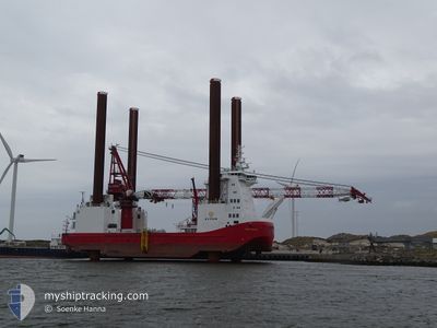
WIND SERVER
Offshore Construction Jack Up
Current Trip
| Time Travelled | --- |
|---|---|
| Remaining Time | -6 mins |
| Distance Travelled | 480.30 nm |
| Remaining Distance | 0.49 nm |
| AVG Speed | 6.3 Noeuds |
| MAX Speed | 10.3 Noeuds |
| AVG Wind | 10.2 knots |
| MAX Wind | 23 knots |
| MIN Temp | 4.4°C / 39.92°F |
| MAX Temp | 14.4°C / 57.92°F |
| Tirant d eau | 5.3 m |
| Position reçue | Maintenant |
Current Position
| Longitude | 8.70984° |
|---|---|
| Latitude | 53.88526° |
| Etat | Under way using engine |
| Vitesse | 7.8 Noeuds |
| Parcours | 329.7° |
| Zone | North Sea |
| Station | T-AIS |
| Position reçue | Maintenant |
Info
Information
The current position of WIND SERVER is in North Sea with coordinates 53.88526° / 8.70984° as reported on 2024-05-12 04:25 by AIS to our vessel tracker app. The vessel's current speed is 7.8 Noeuds and is heading at the port of CUXHAVEN. The estimated time of arrival as calculated by MyShipTracking vessel tracking app is 2024-05-12 04:19 LT
The vessel WIND SERVER (IMO: 9670793, MMSI: 219615000) is a Offshore Construction Jack Up that was built in 2014 ( 10 Age ). It's sailing under the flag of [DK] Denmark.
In this page you can find informations about the vessels current position, last detected port calls, and current voyage information. If the vessels is not in coverage by AIS you will find the latest position.
The current position of WIND SERVER is detected by our AIS receivers and we are not responsible for the reliability of the data. The last position was recorded while the vessel was in Coverage by the Ais receivers of our vessel tracking app.
The current draught of WIND SERVER as reported by AIS is 5.3 meters
Weather
| Temperature | 10.9°C / 51.62°F |
|---|---|
| Wind Speed | 13 knots |
| Direction | 102° ESE |
| Pressure | 1023.4 hPa |
| Humidity | 86.2 % |
| Cloud Coverage | 18 % |
Featured Company
Last Port Calls
Last Trips
| Origin | Departure | Destination | Arrival | Distance |
|---|
Events
| Heure | Evenement | Détails | Position/ Destination | Info |
|---|---|---|---|---|
| 2024-05-12 04:03 | Démarrage | 0.81 nm, North West of ALTENBRUCH |
53.84759 / 8.75571
DE CUX>CUXHAVEN
|
Vitesse: 3.1 kn Parcours: 334° |
| 2024-05-11 22:38 | Arret | 0.97 nm, North West of ALTENBRUCH |
53.84956 / 8.75273
DE CUX>CUXHAVEN
|
Vitesse: 0.3 kn Parcours: 281° |
| 2024-05-11 20:53 | Tirant d'eau modifié | 5.3 5 |
53.96402 / 8.56375
DE CUX>CUXHAVEN
|
Vitesse: 7.1 kn Parcours: 101.1° |
| 2024-05-11 20:53 | Changement d'ETA | 2024/05/11 22:00 |
53.96402 / 8.56375
DE CUX>CUXHAVEN
|
Vitesse: 7.1 kn Parcours: 101.1° |
| 2024-05-11 20:47 | Tirant d'eau modifié | 5 5.3 |
53.96588 / 8.54805
DE CUX>CUXHAVEN
|
Vitesse: 6.1 kn Parcours: 99° |
| 2024-05-11 20:29 | Tirant d'eau modifié | 5.3 5 |
53.97092 / 8.50338
DE CUX>CUXHAVEN
|
Vitesse: 5.2 kn Parcours: 101.3° |
| 2024-05-11 20:29 | Changement d'ETA | 2024/05/11 22:00 |
53.97092 / 8.50338
DE CUX>CUXHAVEN
|
Vitesse: 5.2 kn Parcours: 101.3° |
| 2024-05-11 19:11 | Tirant d'eau modifié | 5 5.3 |
53.98893 / 8.34183
DE CUX>CUXHAVEN
|
Vitesse: 4 kn Parcours: 101° |
| 2024-05-11 18:59 | Tirant d'eau modifié | 5.3 5 |
53.99060 / 8.31170
DE CUX>CUXHAVEN
|
Vitesse: 7.2 kn Parcours: 92° |
| 2024-05-11 18:59 | Changement d'ETA | 2024/05/11 22:00 |
53.99060 / 8.31170
DE CUX>CUXHAVEN
|
Vitesse: 7.2 kn Parcours: 92° |