

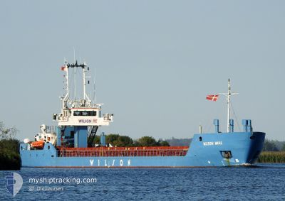
WILSON WAAL
General Cargo

Current Position
| Longitude | --- |
|---|---|
| Latitude | --- |
| Etat | Moored |
| Vitesse | |
| Parcours | 285° |
| Zone | Kattegat |
| Station | T-AIS |
| Position reçue | 4 m depuis |
Information
The current position of WILSON WAAL is in Kattegat with coordinates 55.70669° / 9.54593° as reported on 2025-03-16 05:40 by AIS to our vessel tracker app. The vessel's current speed is 0 Noeuds and is currently inside the port of VEJLE.
The vessel WILSON WAAL (IMO: 9178446, MMSI: 314262000) is a General Cargo that was built in 1999 ( 26 Age ). It's sailing under the flag of [BB] Barbados.
In this page you can find informations about the vessels current position, last detected port calls, and current voyage information. If the vessels is not in coverage by AIS you will find the latest position.
The current position of WILSON WAAL is detected by our AIS receivers and we are not responsible for the reliability of the data. The last position was recorded while the vessel was in Coverage by the Ais receivers of our vessel tracking app.
The current draught of WILSON WAAL as reported by AIS is 4.5 meters
Weather
| Temperature | 1.6°C / 34.88°F |
|---|---|
| Wind Speed | 12 knots |
| Direction | 270° W |
| Pressure | 1017.9 hPa |
| Humidity | 93.8 % |
| Cloud Coverage | 13 % |


Featured Company
Last Port Calls
| Port | Arrival | Departure | Time In Port |
|---|---|---|---|
| 2025-03-14 03:52 | |||
| 2025-03-07 01:07 | |||
| 2025-03-02 17:20 | 2025-03-06 18:16 | 4 d | |
| 2025-02-27 21:19 | 2025-02-28 20:11 | 22 h | |
| 2025-02-22 04:39 | 2025-02-24 02:17 | 1 d | |
| 2025-02-09 19:30 | 2025-02-10 18:33 | 23 h | |
| 2025-02-01 20:31 | 2025-02-04 08:03 | 2 d | |
| 2025-01-28 03:46 | 2025-01-29 13:02 | 1 d | |
| 2025-01-28 02:23 | 2025-01-28 02:47 | 24 m | |
| 2025-01-25 12:04 | 2025-01-27 14:30 | 2 d |
Last Trips
| Origin | Departure | Destination | Arrival | Distance | |
|---|---|---|---|---|---|
| 2025-03-06 18:16 | 2025-03-07 01:07 | 74.70 nm | |||
| 2025-02-28 20:11 | 2025-03-02 17:20 | 469.06 nm | |||
| 2025-02-24 02:17 | 2025-02-27 21:19 | 778.90 nm | |||
| 2025-02-10 18:33 | 2025-02-22 04:39 | 785.94 nm | |||
| 2025-02-04 08:03 | 2025-02-09 19:30 | 746.17 nm | |||
| 2025-01-29 13:02 | 2025-02-01 20:31 | 743.85 nm | |||
| 2025-01-28 02:47 | 2025-01-28 03:46 | 7.75 nm | |||
| 2025-01-27 14:30 | 2025-01-28 02:23 | 110.07 nm | |||
| 2025-01-21 17:05 | 2025-01-25 12:04 | 574.02 nm | |||
| 2025-01-17 12:47 | 2025-01-21 14:46 | 575.26 nm |
Events
| Heure | Evenement | Détails | Position/ Destination | Info |
|---|---|---|---|---|
| 2025-03-14 03:17 | Etat Changé | Moored Under way using engine |
55.70669 / 9.54589
[DK] VEJLE
|
Vitesse: Parcours: 285° |
| 2025-03-14 03:09 | Arret |
55.70663 / 9.54614
[DK] VEJLE
|
Vitesse: 0.2 kn Parcours: 288° |
|
| 2025-03-14 02:52 | Port d'arrivée |
|
55.70307 / 9.56617
[DK] VEJLE
|
Vitesse: 5.9 kn Parcours: 286.2° |
| 2025-03-13 15:03 | Changement de zone | Danish part of the Kattegat Portuguese part of the North Atlantic Ocean |
56.88727 / 10.90410
Kattegat
VEJLE
|
Vitesse: 9.8 kn Parcours: 163.4° |
| 2025-03-13 15:02 | Dans la zone couverte |
56.88727 / 10.90410
Kattegat
VEJLE
|
Vitesse: 9.8 kn Parcours: 163.4° |
|
| 2025-03-13 09:47 | Changement d'ETA | 2025/03/15 04:00 2025/03/13 21:00 |
40.63863 / -8.68090
[PT] AVEIRO
|
Vitesse: Parcours: 254° |
| 2025-03-12 14:37 | Tirant d'eau modifié | 4.5 3 |
40.63863 / -8.68090
[PT] AVEIRO
|
Vitesse: Parcours: 254° |
| 2025-03-12 14:37 | Changement de destination | VEJLE PTAVE |
40.63863 / -8.68090
[PT] AVEIRO
|
Vitesse: Parcours: 254° |
| 2025-03-12 14:37 | Changement d'ETA | 2025/03/13 21:00 2025/03/02 18:00 |
40.63863 / -8.68090
[PT] AVEIRO
|
Vitesse: Parcours: 254° |
| 2025-03-12 08:07 | Hors de la zone couverte |
40.63863 / -8.68090
North Atlantic Ocean
[PT] AVEIRO
|
Vitesse: Parcours: 329.3° |