

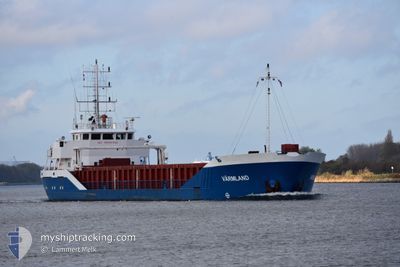
VARMLAND
General Cargo

Current Trip
| Time Travelled | 3 days |
|---|---|
| Remaining Time | 9 h, 52 mins |
| Distance Travelled | 351.69 nm |
| Remaining Distance | 177.34 nm |
| AVG Speed | 9.2 Noeuds |
| MAX Speed | 11.7 Noeuds |
| AVG Wind | 12.2 knots |
| MAX Wind | 23 knots |
| MIN Temp | 1.6°C / 34.88°F |
| MAX Temp | 4.5°C / 40.1°F |
| Tirant d eau | 4.2 m |
| Position reçue | 13 h, 21 m depuis |
Current Position
| Longitude | --- |
|---|---|
| Latitude | --- |
| Etat | Under way using engine |
| Vitesse | 10 Noeuds |
| Parcours | 245.2° |
| Zone | Baltic Sea |
| Station | T-AIS |
| Position reçue | 13 h, 21 m depuis |
Information
The current position of VARMLAND is in Baltic Sea with coordinates 59.21341° / 22.60919° as reported on 2025-03-27 07:36 by AIS to our vessel tracker app. The vessel's current speed is 10 Noeuds and is heading at the port of KLAIPEDA. The estimated time of arrival as calculated by MyShipTracking vessel tracking app is 2025-03-28 06:49 LT
The vessel VARMLAND (IMO: 9191943, MMSI: 255806444) is a General Cargo that was built in 2007 ( 18 Age ). It's sailing under the flag of [PT] Portugal.
In this page you can find informations about the vessels current position, last detected port calls, and current voyage information. If the vessels is not in coverage by AIS you will find the latest position.
The current position of VARMLAND is detected by our AIS receivers and we are not responsible for the reliability of the data. The last position was recorded while the vessel was in Coverage by the Ais receivers of our vessel tracking app.
The current draught of VARMLAND as reported by AIS is 4.2 meters
Weather
| Temperature | 4.5°C / 40.1°F |
|---|---|
| Wind Speed | 21 knots |
| Direction | 210° SSW |
| Pressure | 1013.6 hPa |
| Humidity | 93.5 % |
| Cloud Coverage | 100 % |


Featured Company
Last Port Calls
| Port | Arrival | Departure | Time In Port |
|---|---|---|---|
| 2025-03-24 03:22 | 2025-03-24 19:11 | 15 h | |
| 2025-03-21 07:10 | 2025-03-21 22:45 | 15 h | |
| 2025-03-18 01:02 | 2025-03-19 06:10 | 1 d | |
| 2025-03-16 10:30 | 2025-03-17 14:45 | 1 d | |
| 2025-03-10 18:14 | 2025-03-11 17:13 | 22 h | |
| 2025-03-09 05:08 | |||
| 2025-03-01 20:46 | 2025-03-03 00:17 | 1 d | |
| 2025-02-20 06:01 | 2025-02-21 08:40 | 1 d | |
| 2025-02-16 08:06 | 2025-02-17 05:24 | 21 h | |
| 2025-02-13 19:19 | 2025-02-14 11:34 | 16 h |
Last Trips
| Origin | Departure | Destination | Arrival | Distance | |
|---|---|---|---|---|---|
| 2025-03-22 00:45 | 2025-03-24 05:22 | 132.46 nm | |||
| 2025-03-19 08:10 | 2025-03-21 09:10 | 166.85 nm | |||
| 2025-03-17 16:45 | 2025-03-18 03:02 | 114.97 nm | |||
| 2025-03-11 19:13 | 2025-03-16 12:30 | 656.48 nm | |||
| 2025-03-09 07:08 | 2025-03-10 20:14 | 362.78 nm | |||
| 2025-02-21 10:40 | 2025-03-01 22:46 | 1382.91 nm | |||
| 2025-02-17 07:24 | 2025-02-20 08:01 | 638.66 nm | |||
| 2025-02-14 13:34 | 2025-02-16 10:06 | 133.20 nm | |||
| 2025-02-08 12:17 | 2025-02-13 21:19 | 711.49 nm | |||
| 2025-02-06 03:29 | 2025-02-07 14:57 | 358.41 nm |
Events
| Heure | Evenement | Détails | Position/ Destination | Info |
|---|---|---|---|---|
| 2025-03-27 07:37 | Etat Changé | Default Under way using engine |
59.21197 / 22.60324
LTKLJ
|
Vitesse: 10 kn Parcours: 245.2° |
| 2025-03-27 07:36 | Hors de la zone couverte |
59.21341 / 22.60919
Baltic Sea
LTKLJ
|
Vitesse: 10 kn Parcours: 245.2° |
|
| 2025-03-27 05:17 | Detecté en mer | Estonian part of the Baltic Sea |
59.38270 / 23.29489
Baltic Sea
LTKLJ
|
Vitesse: 9.9 kn Parcours: 243.5° |
| 2025-03-26 21:37 | Changement de zone | Estonian part of the Gulf of Finland Finnish part of the Gulf of Finland |
59.86551 / 25.61582
Gulf of Finland
LTKLJ
|
Vitesse: 9.9 kn Parcours: 196.6° |
| 2025-03-26 19:49 | Etat Changé | Under way using engine Default |
60.04592 / 26.09029
LTKLJ
|
Vitesse: 10.1 kn Parcours: 225° |
| 2025-03-26 19:35 | Etat Changé | Default Under way using engine |
60.07431 / 26.14883
LTKLJ
|
Vitesse: 10 kn Parcours: 224.6° |
| 2025-03-26 16:29 | Etat Changé | Under way using engine Moored |
60.43896 / 26.92963
LTKLJ
|
Vitesse: 4.6 kn Parcours: 78° |
| 2025-03-26 16:27 | Démarrage | 2.67 nm, South West of KOTKA |
60.43826 / 26.92119
LTKLJ
|
Vitesse: 4.6 kn Parcours: 78° |
| 2025-03-26 16:27 | Etat Changé | Moored Default |
60.43818 / 26.92027
LTKLJ
|
Vitesse: 3.4 kn Parcours: 78° |
| 2025-03-26 16:18 | Etat Changé | Default Moored |
60.43780 / 26.91606
LTKLJ
|
Vitesse: Parcours: 66° |