
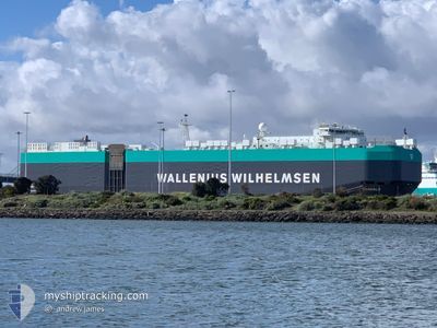
TONGALA
Vehicles Carrier
Current Trip
| Time Travelled | 9 days |
|---|---|
| Remaining Time | 11 h, 37 mins |
| Distance Travelled | 4361.61 nm |
| Remaining Distance | 251.86 nm |
| AVG Speed | 17.3 Noeuds |
| MAX Speed | 22.4 Noeuds |
| AVG Wind | 13.3 knots |
| MAX Wind | 26.9 knots |
| MIN Temp | 20°C / 68°F |
| MAX Temp | 31.5°C / 88.7°F |
| Tirant d eau | 8.8 m |
| Position reçue | 3 h, 10 m depuis |
Current Position
| Longitude | -75.99408° |
|---|---|
| Latitude | 10.25648° |
| Etat | Under way using engine |
| Vitesse | 17 Noeuds |
| Parcours | 257.2° |
| Zone | Caribbean Sea |
| Station | T-AIS |
| Position reçue | 3 h, 10 m depuis |
Info
Information
The current position of TONGALA is in Caribbean Sea with coordinates 10.25648° / -75.99408° as reported on 2024-09-18 04:38 by AIS to our vessel tracker app. The vessel's current speed is 17 Noeuds and is heading at the port of MANZANILLO. The estimated time of arrival as calculated by MyShipTracking vessel tracking app is 2024-09-18 19:26 LT
The vessel TONGALA (IMO: 9605786, MMSI: 215654000) is a Vehicles Carrier that was built in 2012 ( 12 Age ). It's sailing under the flag of [MT] Malta.
In this page you can find informations about the vessels current position, last detected port calls, and current voyage information. If the vessels is not in coverage by AIS you will find the latest position.
The current position of TONGALA is detected by our AIS receivers and we are not responsible for the reliability of the data. The last position was recorded while the vessel was in Coverage by the Ais receivers of our vessel tracking app.
The current draught of TONGALA as reported by AIS is 8.8 meters
Weather
| Temperature | --- |
|---|---|
| Wind Speed | --- |
| Direction | --- |
| Pressure | --- |
| Humidity | --- |
| Cloud Coverage | --- |
Featured Company
Last Port Calls
| Port | Arrival | Departure | Time In Port |
|---|---|---|---|
| 2024-09-07 16:33 | 2024-09-08 08:32 | 15 h | |
| 2024-09-04 20:18 | 2024-09-05 06:41 | 10 h | |
| 2024-09-02 10:39 | 2024-09-03 00:19 | 13 h | |
| 2024-09-02 09:55 | 2024-09-02 10:01 | 5 m | |
| 2024-08-13 14:16 | 2024-08-14 05:14 | 14 h | |
| 2024-08-08 04:07 | 2024-08-08 21:42 | 17 h | |
| 2024-08-05 10:07 | 2024-08-06 04:26 | 18 h | |
| 2024-08-02 23:22 | 2024-08-03 19:49 | 20 h | |
| 2024-07-28 03:07 | 2024-07-29 06:41 | 1 d | |
| 2024-07-12 14:54 | 2024-07-13 15:10 | 1 d |
Most Visited Ports (Last year)
| Port | Arrivals | |
|---|---|---|
| 3 | ||
| 3 | ||
| 2 | ||
| 2 | ||
| 2 | ||
| 2 |
Last Trips
| Origin | Departure | Destination | Arrival | Distance | |
|---|---|---|---|---|---|
| 2024-09-05 03:41 | 2024-09-07 13:33 | 239.28 nm | |||
| 2024-09-02 21:19 | 2024-09-04 17:18 | 357.84 nm | |||
| 2024-09-02 07:01 | 2024-09-02 07:39 | 1.55 nm | |||
| 2024-08-14 00:14 | 2024-09-02 06:55 | 4443.18 nm | |||
| 2024-08-08 16:42 | 2024-08-13 09:16 | 1526.18 nm | |||
| 2024-08-05 23:26 | 2024-08-07 23:07 | 494.35 nm | |||
| 2024-08-03 14:49 | 2024-08-05 05:07 | 637.42 nm | |||
| 2024-07-29 01:41 | 2024-08-02 18:22 | 1490.50 nm | |||
| 2024-07-13 12:10 | 2024-07-27 22:07 | 4543.51 nm | |||
| 2024-07-05 02:54 | 2024-07-12 11:54 | 1008.19 nm |
Events
| Heure | Evenement | Détails | Position/ Destination | Info |
|---|---|---|---|---|
| 2024-09-18 04:48 | Etat Changé | Default Under way using engine |
10.24731 / -76.03719
PA MIT
|
Vitesse: 17 kn Parcours: 257.2° |
| 2024-09-18 04:38 | Hors de la zone couverte |
10.25648 / -75.99408
Caribbean Sea
PA MIT
|
Vitesse: 17 kn Parcours: 257.2° |
|
| 2024-09-18 02:47 | Démarrage | 5.64 nm, South of CARTAGENA |
10.29464 / -75.53634
PA MIT
|
Vitesse: 3.1 kn Parcours: 333° |
| 2024-09-18 02:36 | Etat Changé | Under way using engine Moored |
10.29057 / -75.53373
PA MIT
|
Vitesse: Parcours: 55° |
| 2024-09-17 23:11 | Changement de destination | PA MIT CO CTG |
10.29053 / -75.53369
PA MIT
|
Vitesse: 0.1 kn Parcours: 55° |
| 2024-09-17 23:11 | Changement d'ETA | 2024/09/18 20:00 2024/09/17 18:00 |
10.29053 / -75.53369
PA MIT
|
Vitesse: 0.1 kn Parcours: 55° |
| 2024-09-17 22:16 | Etat Changé | Moored Under way using engine |
10.29057 / -75.53369
CO CTG
|
Vitesse: Parcours: 55° |
| 2024-09-17 19:52 | Arret | 5.89 nm, South of CARTAGENA |
10.29060 / -75.53441
CO CTG
|
Vitesse: 0.3 kn Parcours: 57° |
| 2024-09-17 14:53 | Tirant d'eau modifié | 8.8 8.9 |
10.82247 / -75.52959
CO CTG
|
Vitesse: 17.3 kn Parcours: 230.7° |
| 2024-09-17 14:53 | Changement d'ETA | 2024/09/17 18:00 2024/09/18 05:00 |
10.82247 / -75.52959
CO CTG
|
Vitesse: 17.3 kn Parcours: 230.7° |