

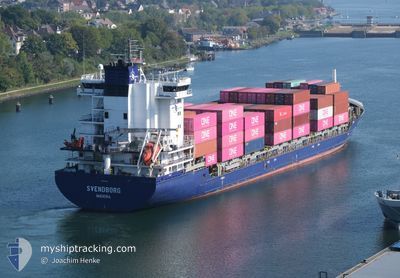
SVENDBORG
Container Ship

Current Trip
| Time Travelled | 1 day |
|---|---|
| Remaining Time | --- |
| Distance Travelled | 86.47 nm |
| Remaining Distance | 14.12 nm |
| AVG Speed | 12.9 Noeuds |
| MAX Speed | 16.5 Noeuds |
| AVG Wind | 10.1 knots |
| MAX Wind | 16 knots |
| MIN Temp | 3.8°C / 38.84°F |
| MAX Temp | 6.2°C / 43.16°F |
| Tirant d eau | 5.9 m |
| Position reçue | 57 m depuis |
Current Position
| Longitude | --- |
|---|---|
| Latitude | --- |
| Etat | At anchor |
| Vitesse | 0.2 Noeuds |
| Parcours | 19° |
| Zone | North Sea |
| Station | T-AIS |
| Position reçue | 57 m depuis |
Information
The current position of SVENDBORG is in North Sea with coordinates 51.93590° / 3.80585° as reported on 2025-03-12 20:21 by AIS to our vessel tracker app. The vessel's current speed is 0.2 Noeuds and is heading at the port of ROTTERDAM. The estimated time of arrival as calculated by MyShipTracking vessel tracking app is 2025-03-12 11:00 LT
The vessel SVENDBORG (IMO: 9454230, MMSI: 255805594) is a Container Ship that was built in 2011 ( 14 Age ). It's sailing under the flag of [PT] Portugal.
In this page you can find informations about the vessels current position, last detected port calls, and current voyage information. If the vessels is not in coverage by AIS you will find the latest position.
The current position of SVENDBORG is detected by our AIS receivers and we are not responsible for the reliability of the data. The last position was recorded while the vessel was in Coverage by the Ais receivers of our vessel tracking app.
The current draught of SVENDBORG as reported by AIS is 5.9 meters
Weather
| Temperature | 5.8°C / 42.44°F |
|---|---|
| Wind Speed | 7 knots |
| Direction | 344° NNW |
| Pressure | 1000.4 hPa |
| Humidity | 64.9 % |
| Cloud Coverage | 100 % |


Featured Company
Last Port Calls
| Port | Arrival | Departure | Time In Port |
|---|---|---|---|
| 2025-03-11 10:10 | 2025-03-11 20:49 | 10 h | |
| 2025-03-10 00:42 | 2025-03-10 02:11 | 1 h | |
| 2025-03-09 14:59 | 2025-03-09 16:09 | 1 h | |
| 2025-03-06 19:49 | 2025-03-07 13:18 | 17 h | |
| 2025-03-06 02:12 | 2025-03-06 10:42 | 8 h | |
| 2025-03-03 04:27 | 2025-03-04 09:15 | 1 d | |
| 2025-03-01 04:40 | 2025-03-01 11:40 | 6 h | |
| 2025-02-25 22:03 | 2025-02-26 12:03 | 13 h | |
| 2025-02-23 18:24 | 2025-02-24 07:34 | 13 h | |
| 2025-02-19 16:04 | 2025-02-20 06:09 | 14 h |
Most Visited Ports (Last year)
| Port | Arrivals | |
|---|---|---|
| 21 | ||
| 19 | ||
| 17 | ||
| 17 | ||
| 11 | ||
| 9 |
Last Trips
| Origin | Departure | Destination | Arrival | Distance | |
|---|---|---|---|---|---|
| 2025-03-10 03:11 | 2025-03-11 11:10 | 369.83 nm | |||
| 2025-03-09 17:09 | 2025-03-10 01:42 | 50.23 nm | |||
| 2025-03-07 14:18 | 2025-03-09 15:59 | 622.73 nm | |||
| 2025-03-06 12:42 | 2025-03-06 20:49 | 128.61 nm | |||
| 2025-03-04 10:15 | 2025-03-06 04:12 | 497.17 nm | |||
| 2025-03-01 12:40 | 2025-03-03 05:27 | 443.95 nm | |||
| 2025-02-26 13:03 | 2025-03-01 05:40 | 303.26 nm | |||
| 2025-02-24 08:34 | 2025-02-25 23:03 | 97.43 nm | |||
| 2025-02-20 07:09 | 2025-02-23 19:24 | 1044.65 nm | |||
| 2025-02-19 09:53 | 2025-02-19 17:04 | 128.55 nm |
Events
| Heure | Evenement | Détails | Position/ Destination | Info |
|---|---|---|---|---|
| 2025-03-12 20:24 | Etat Changé | Default At anchor |
51.93590 / 3.80581
BE ANR >>> NL RTM
|
Vitesse: 0.2 kn Parcours: 19° |
| 2025-03-12 20:21 | Etat Changé | At anchor Default |
51.93590 / 3.80585
BE ANR >>> NL RTM
|
Vitesse: 0.2 kn Parcours: 18° |
| 2025-03-12 20:15 | Dans la zone couverte |
51.93590 / 3.80585
North Sea
|
Vitesse: 0.2 kn Parcours: 215.9° |
|
| 2025-03-12 11:11 | Etat Changé | Default At anchor |
51.93460 / 3.80696
BE ANR >>> NL RTM
|
Vitesse: 0.2 kn Parcours: 6° |
| 2025-03-12 11:09 | Etat Changé | At anchor Default |
51.93462 / 3.80674
BE ANR >>> NL RTM
|
Vitesse: 0.2 kn Parcours: 18° |
| 2025-03-12 11:09 | Dans la zone couverte |
51.93462 / 3.80674
North Sea
|
Vitesse: 0.2 kn Parcours: 104.6° |
|
| 2025-03-12 11:09 | Hors de la zone couverte |
51.93462 / 3.80674
North Sea
|
Vitesse: 0.2 kn Parcours: 104.6° |
|
| 2025-03-12 07:24 | Etat Changé | Default At anchor |
51.93486 / 3.80647
BE ANR >>> NL RTM
|
Vitesse: 0.2 kn Parcours: 9° |
| 2025-03-12 07:24 | Etat Changé | At anchor Default |
51.93486 / 3.80647
BE ANR >>> NL RTM
|
Vitesse: 0.1 kn Parcours: 7° |
| 2025-03-12 07:24 | Hors de la zone couverte |
51.93486 / 3.80647
North Sea
|
Vitesse: 0.2 kn Parcours: 320.4° |