
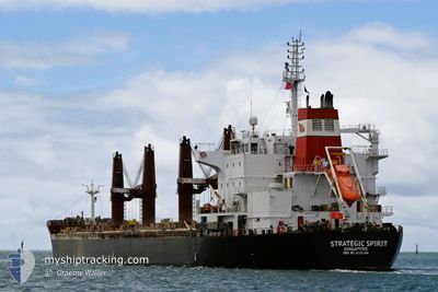
STRATEGIC SPIRIT
Bulk Carrier
Current Trip
TURKEY
| Time Travelled | 6 days |
|---|---|
| Remaining Time | --- |
| Distance Travelled | 1367.15 nm |
| Remaining Distance | --- |
| AVG Speed | 9.3 Noeuds |
| MAX Speed | 12.7 Noeuds |
| AVG Wind | 27.8 knots |
| MAX Wind | 39.8 knots |
| MIN Temp | 5.8°C / 42.44°F |
| MAX Temp | 15.3°C / 59.54°F |
| Tirant d eau | 10.5 m |
| Position reçue | 5 d depuis |
Current Position
| Longitude | --- |
|---|---|
| Latitude | --- |
| Etat | Under way using engine |
| Vitesse | 10.6 Noeuds |
| Parcours | 99.9° |
| Zone | North Atlantic Ocean |
| Station | T-AIS |
| Position reçue | 5 d depuis |
Info
Information
The current position of STRATEGIC SPIRIT is in North Atlantic Ocean with coordinates 40.39064° / -73.42329° as reported on 2024-11-22 02:43 by AIS to our vessel tracker app. The vessel's current speed is 10.6 Noeuds
The vessel STRATEGIC SPIRIT (IMO: 9626388, MMSI: 563049700) is a Bulk Carrier that was built in 2012 ( 12 Age ). It's sailing under the flag of [SG] Singapore.
In this page you can find informations about the vessels current position, last detected port calls, and current voyage information. If the vessels is not in coverage by AIS you will find the latest position.
The current position of STRATEGIC SPIRIT is detected by our AIS receivers and we are not responsible for the reliability of the data. The last position was recorded while the vessel was in Coverage by the Ais receivers of our vessel tracking app.
The current draught of STRATEGIC SPIRIT as reported by AIS is 10.5 meters
Weather
| Temperature | 15.6°C / 60.08°F |
|---|---|
| Wind Speed | 19 knots |
| Direction | 306° NW |
| Pressure | 1010.1 hPa |
| Humidity | 62.9 % |
| Cloud Coverage | 66 % |
Featured Company
Last Port Calls
| Port | Arrival | Departure | Time In Port |
|---|---|---|---|
| 2024-11-20 06:58 | 2024-11-21 23:33 | 1 d | |
| 2024-11-14 18:29 | 2024-11-19 18:08 | 4 d | |
| 2024-10-31 16:50 | |||
| 2024-10-22 09:08 | 2024-10-24 23:31 | 2 d | |
| 2024-09-27 03:57 | 2024-10-03 06:45 | 6 d | |
| 2024-09-24 00:12 | 2024-09-24 17:02 | 16 h | |
| 2024-09-22 22:47 | 2024-09-22 23:49 | 1 h | |
| 2024-09-19 08:16 | 2024-09-21 05:07 | 1 d | |
| 2024-09-08 13:11 | 2024-09-17 11:43 | 8 d | |
| 2024-09-04 05:27 | 2024-09-07 10:16 | 3 d |
Most Visited Ports (Last year)
| Port | Arrivals | |
|---|---|---|
| 2 | ||
| 2 | ||
| 2 | ||
| 1 | ||
| 1 | ||
| 1 |
Last Trips
| Origin | Departure | Destination | Arrival | Distance | |
|---|---|---|---|---|---|
| 2024-11-19 13:08 | 2024-11-20 01:58 | 116.64 nm | |||
| 2024-10-31 16:50 | 2024-11-14 13:29 | 3166.32 nm | |||
| 2024-10-03 01:45 | 2024-10-22 10:08 | 4862.77 nm | |||
| 2024-09-24 12:02 | 2024-09-26 22:57 | 680.43 nm | |||
| 2024-09-22 18:49 | 2024-09-23 19:12 | 13.12 nm | |||
| 2024-09-21 00:07 | 2024-09-22 17:47 | 495.71 nm | |||
| 2024-09-17 06:43 | 2024-09-19 03:16 | 443.56 nm | |||
| 2024-09-07 05:16 | 2024-09-08 08:11 | 317.64 nm | |||
| 2024-08-20 03:00 | 2024-09-04 00:27 | 3516.81 nm |
Events
| Heure | Evenement | Détails | Position/ Destination | Info |
|---|---|---|---|---|
| 2024-11-22 02:50 | Etat Changé | Default Under way using engine |
40.38667 / -73.39833
TURKEY
|
Vitesse: 10.6 kn Parcours: 99.9° |
| 2024-11-22 02:43 | Hors de la zone couverte |
40.39064 / -73.42329
North Atlantic Ocean
TURKEY
|
Vitesse: 10.6 kn Parcours: 99.9° |
|
| 2024-11-21 23:33 | PORT DE DEPART |
|
40.57712 / -74.03492
TURKEY
|
Vitesse: 12.6 kn Parcours: 168° |
| 2024-11-21 23:27 | Etat Changé | Under way using engine Moored |
40.59779 / -74.04187
[US] NEW YORK
|
Vitesse: 12.6 kn Parcours: 165° |
| 2024-11-21 23:27 | Etat Changé | Moored Under way using engine |
40.59898 / -74.04230
[US] NEW YORK
|
Vitesse: 12.6 kn Parcours: 165° |
| 2024-11-21 22:14 | Etat Changé | Under way using engine Moored |
40.68023 / -74.14257
[US] NEW YORK
|
Vitesse: 3.1 kn Parcours: 180° |
| 2024-11-21 22:14 | Démarrage |
40.68039 / -74.14253
[US] NEW YORK
|
Vitesse: 3.1 kn Parcours: 180° |
|
| 2024-11-21 21:47 | Changement d'ETA | 2024/12/11 09:00 2024/11/20 07:00 |
40.68467 / -74.13940
[US] NEW YORK
|
Vitesse: Parcours: 214° |
| 2024-11-21 21:40 | Changement de destination | TURKEY GIB |
40.68464 / -74.13938
[US] NEW YORK
|
Vitesse: Parcours: 214° |
| 2024-11-21 21:39 | Changement de destination | GIB NEWARK |
40.68464 / -74.13938
[US] NEW YORK
|
Vitesse: Parcours: 214° |