
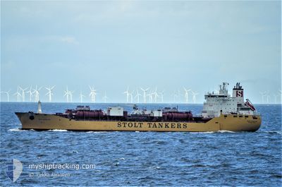
STOLT CREATIVITY
Oil/Chemical Tanker
Current Trip
| Trip Time | 2 days |
|---|---|
| Trip Distance | 70.96 nm |
| AVG Speed | 12.9 Noeuds |
| MAX Speed | 17.1 Noeuds |
| Tirant d eau | 10.3 m |
| AVG Wind | 12.9 knots |
| MAX Wind | 19 knots |
| MIN Temp | 24.5°C / 76.1°F |
| MAX Temp | 27.7°C / 81.86°F |
| Position reçue | 4 h, 2 m depuis |
Current Position
| Longitude | -95.12020° |
|---|---|
| Latitude | 29.73847° |
| Etat | Moored |
| Vitesse | |
| Parcours | 55° |
| Zone | Gulf of Mexico |
| Station | T-AIS |
| Position reçue | 4 h, 2 m depuis |
Info
Information
The current position of STOLT CREATIVITY is in Gulf of Mexico with coordinates 29.73847° / -95.12020° as reported on 2024-05-21 01:08 by AIS to our vessel tracker app. The vessel's current speed is 0 Noeuds and is currently inside the port of HOUSTON.
The vessel STOLT CREATIVITY (IMO: 9102095, MMSI: 319498000) is a Oil/Chemical Tanker that was built in 1997 ( 27 Age ). It's sailing under the flag of [KY] Cayman Is.
In this page you can find informations about the vessels current position, last detected port calls, and current voyage information. If the vessels is not in coverage by AIS you will find the latest position.
The current position of STOLT CREATIVITY is detected by our AIS receivers and we are not responsible for the reliability of the data. The last position was recorded while the vessel was in Coverage by the Ais receivers of our vessel tracking app.
The current draught of STOLT CREATIVITY as reported by AIS is 11.5 meters
Weather
| Temperature | 25.6°C / 78.08°F |
|---|---|
| Wind Speed | 11 knots |
| Direction | 133° SE |
| Pressure | 1010.5 hPa |
| Humidity | 91.2 % |
| Cloud Coverage | 50 % |
Featured Company
Last Port Calls
| Port | Arrival | Departure | Time In Port |
|---|---|---|---|
| 2024-05-09 11:51 | |||
| 2024-05-06 00:15 | 2024-05-06 20:17 | 20 h | |
| 2024-04-30 17:56 | 2024-05-02 02:34 | 1 d | |
| 2024-04-24 20:46 | 2024-04-27 20:42 | 2 d | |
| 2024-04-17 02:10 | 2024-04-18 03:06 | 1 d | |
| 2024-04-17 01:04 | 2024-04-17 01:24 | 20 m | |
| 2024-04-14 02:45 | 2024-04-15 19:56 | 1 d | |
| 2024-03-06 02:15 | 2024-03-06 21:28 | 19 h | |
| 2024-03-04 02:32 | 2024-03-05 19:56 | 1 d | |
| 2024-03-02 11:02 |
Most Visited Ports (Last year)
| Port | Arrivals | |
|---|---|---|
| 10 | ||
| 6 | ||
| 5 | ||
| 4 | ||
| 3 | ||
| 3 |
Last Trips
| Origin | Departure | Destination | Arrival | Distance | |
|---|---|---|---|---|---|
| 2024-05-06 15:17 | 2024-05-09 06:51 | 70.96 nm | |||
| 2024-05-01 21:34 | 2024-05-05 19:15 | 537.56 nm | |||
| 2024-04-27 15:42 | 2024-04-30 12:56 | 54.39 nm | |||
| 2024-04-17 23:06 | 2024-04-24 15:46 | 1701.20 nm | |||
| 2024-04-16 21:24 | 2024-04-16 22:10 | 3.25 nm | |||
| 2024-04-15 15:56 | 2024-04-16 21:04 | 289.13 nm | |||
| 2024-03-07 05:28 | 2024-04-13 22:45 | 12624.06 nm | |||
| 2024-03-06 02:56 | 2024-03-06 10:15 | 35.14 nm | |||
| 2024-03-02 18:02 | 2024-03-04 09:32 | 413.05 nm |
Events
| Heure | Evenement | Détails | Position/ Destination | Info |
|---|---|---|---|---|
| 2024-05-21 01:14 | Etat Changé | Default Moored |
29.73848 / -95.12022
[US] HOUSTON
|
Vitesse: Parcours: 55° |
| 2024-05-21 01:08 | Hors de la zone couverte |
29.73847 / -95.12020
Gulf of Mexico
[US] HOUSTON
|
Vitesse: Parcours: 183.8° |
|
| 2024-05-21 01:05 | Etat Changé | Moored Default |
29.73850 / -95.12021
[US] HOUSTON
|
Vitesse: Parcours: 55° |
| 2024-05-21 00:50 | Dans la zone couverte |
29.73850 / -95.12021
Gulf of Mexico
[US] HOUSTON
|
Vitesse: Parcours: 183.8° |
|
| 2024-05-21 00:43 | Tirant d'eau modifié | 11.5 11.3 |
29.73848 / -95.12023
[US] HOUSTON
|
Vitesse: Parcours: 55° |
| 2024-05-20 13:32 | Etat Changé | Default Moored |
29.73849 / -95.12022
[US] HOUSTON
|
Vitesse: Parcours: 55° |
| 2024-05-20 13:29 | Hors de la zone couverte |
29.73847 / -95.12022
Gulf of Mexico
[US] HOUSTON
|
Vitesse: Parcours: 183.8° |
|
| 2024-05-20 13:08 | Etat Changé | Moored Default |
29.73848 / -95.12021
[US] HOUSTON
|
Vitesse: Parcours: 55° |
| 2024-05-20 12:44 | Etat Changé | Default Moored |
29.73848 / -95.12022
[US] HOUSTON
|
Vitesse: Parcours: 55° |
| 2024-05-20 12:32 | Etat Changé | Moored Default |
29.73845 / -95.12023
[US] HOUSTON
|
Vitesse: Parcours: 55° |