
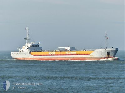
STAR BONAIRE
Edible Oil Tanker
Current Trip
| Time Travelled | 12 h, 12 mins |
|---|---|
| Remaining Time | 4 h, 43 mins |
| Distance Travelled | 125.05 nm |
| Remaining Distance | 48.68 nm |
| AVG Speed | 8.7 Noeuds |
| MAX Speed | 14.4 Noeuds |
| AVG Wind | 14.6 knots |
| MAX Wind | 17 knots |
| MIN Temp | -0.8°C / 30.56°F |
| MAX Temp | 3.8°C / 38.84°F |
| Tirant d eau | 5.5 m |
| Position reçue | 1 m depuis |
Current Position
| Longitude | --- |
|---|---|
| Latitude | --- |
| Etat | Under way using engine |
| Vitesse | 9.4 Noeuds |
| Parcours | 307.8° |
| Zone | North Sea |
| Station | T-AIS |
| Position reçue | 1 m depuis |
Info
Information
The current position of STAR BONAIRE is in North Sea with coordinates 51.46527° / 1.41508° as reported on 2025-02-18 10:30 by AIS to our vessel tracker app. The vessel's current speed is 9.4 Noeuds and is heading at the port of PURFLEET. The estimated time of arrival as calculated by MyShipTracking vessel tracking app is 2025-02-18 15:14 LT
The vessel STAR BONAIRE (IMO: 9148453, MMSI: 246359000) is a Edible Oil Tanker that was built in 1997 ( 28 Age ). It's sailing under the flag of [NL] Netherlands.
In this page you can find informations about the vessels current position, last detected port calls, and current voyage information. If the vessels is not in coverage by AIS you will find the latest position.
The current position of STAR BONAIRE is detected by our AIS receivers and we are not responsible for the reliability of the data. The last position was recorded while the vessel was in Coverage by the Ais receivers of our vessel tracking app.
The current draught of STAR BONAIRE as reported by AIS is 5.5 meters
Weather
| Temperature | 3.8°C / 38.84°F |
|---|---|
| Wind Speed | 17 knots |
| Direction | 115° ESE |
| Pressure | 1022.6 hPa |
| Humidity | 67 % |
| Cloud Coverage | 59 % |
Featured Company
Last Port Calls
| Port | Arrival | Departure | Time In Port |
|---|---|---|---|
| 2025-02-16 16:45 | 2025-02-17 22:19 | 1 d | |
| 2025-02-14 21:08 | 2025-02-15 19:06 | 21 h | |
| 2025-02-12 18:10 | 2025-02-13 14:20 | 20 h | |
| 2025-02-10 12:06 | 2025-02-11 19:19 | 1 d | |
| 2025-02-08 19:18 | 2025-02-09 09:43 | 14 h | |
| 2025-02-04 18:42 | 2025-02-06 12:28 | 1 d | |
| 2025-02-03 21:46 | 2025-02-03 21:49 | 3 m | |
| 2025-02-01 01:21 | 2025-02-02 07:48 | 1 d | |
| 2025-01-30 08:09 | 2025-01-31 11:02 | 1 d | |
| 2025-01-27 16:36 | 2025-01-29 15:10 | 1 d |
Most Visited Ports (Last year)
| Port | Arrivals | |
|---|---|---|
| 29 | ||
| 27 | ||
| 27 | ||
| 26 | ||
| 19 | ||
| 10 |
Last Trips
| Origin | Departure | Destination | Arrival | Distance | |
|---|---|---|---|---|---|
| 2025-02-15 19:06 | 2025-02-16 17:45 | 232.45 nm | |||
| 2025-02-13 14:20 | 2025-02-14 21:08 | 264.86 nm | |||
| 2025-02-11 19:19 | 2025-02-12 18:10 | 237.80 nm | |||
| 2025-02-09 10:43 | 2025-02-10 12:06 | 196.84 nm | |||
| 2025-02-06 13:28 | 2025-02-08 20:18 | 560.99 nm | |||
| 2025-02-03 22:49 | 2025-02-04 19:42 | 234.60 nm | |||
| 2025-02-02 08:48 | 2025-02-03 22:46 | 345.63 nm | |||
| 2025-01-31 11:02 | 2025-02-01 02:21 | 167.13 nm | |||
| 2025-01-29 16:10 | 2025-01-30 08:09 | 170.29 nm | |||
| 2025-01-25 08:58 | 2025-01-27 17:36 | 571.64 nm |
Events
| Heure | Evenement | Détails | Position/ Destination | Info |
|---|---|---|---|---|
| 2025-02-18 06:53 | Etat Changé | Under way using engine Default |
51.65017 / 1.99353
PURFLEET
|
Vitesse: 10.1 kn Parcours: 236° |
| 2025-02-18 06:19 | Etat Changé | Default Under way using engine |
51.70425 / 2.12075
PURFLEET
|
Vitesse: 9.8 kn Parcours: 231.5° |
| 2025-02-18 06:17 | Etat Changé | Under way using engine Default |
51.70782 / 2.12828
PURFLEET
|
Vitesse: 9.8 kn Parcours: 232° |
| 2025-02-18 06:17 | Dans la zone couverte |
51.70782 / 2.12828
North Sea
PURFLEET
|
Vitesse: 9.8 kn Parcours: 231.5° |
|
| 2025-02-18 06:17 | Detecté en mer | United Kingdom part of the North Sea |
51.70782 / 2.12828
North Sea
PURFLEET
|
Vitesse: 9.8 kn Parcours: 231.5° |
| 2025-02-18 04:06 | Etat Changé | Default Under way using engine |
51.93107 / 2.57933
PURFLEET
|
Vitesse: 10.2 kn Parcours: 234.3° |
| 2025-02-18 04:02 | Hors de la zone couverte |
51.93823 / 2.59568
North Sea
PURFLEET
|
Vitesse: 10.2 kn Parcours: 234.3° |
|
| 2025-02-18 03:48 | Etat Changé | Under way using engine Default |
51.96092 / 2.64670
PURFLEET
|
Vitesse: 10.4 kn Parcours: 235° |
| 2025-02-18 03:41 | Dans la zone couverte |
51.96092 / 2.64670
North Sea
PURFLEET
|
Vitesse: 10.4 kn Parcours: 233.9° |
|
| 2025-02-18 02:23 | Hors de la zone couverte |
52.02895 / 3.03922
North Sea
PURFLEET
|
Vitesse: 11.4 kn Parcours: 267.9° |