
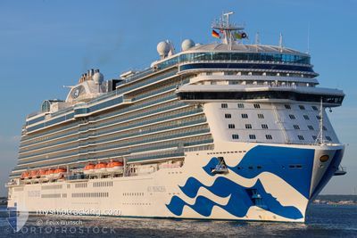
SKY PRINCESS
Passenger
Current Trip
| Time Travelled | 8 days |
|---|---|
| Remaining Time | 2 h, 47 mins |
| Distance Travelled | 3400.74 nm |
| Remaining Distance | 44.89 nm |
| AVG Speed | 17.1 Noeuds |
| MAX Speed | 20.2 Noeuds |
| AVG Wind | 17.6 knots |
| MAX Wind | 34.8 knots |
| MIN Temp | 17.2°C / 62.96°F |
| MAX Temp | 25.8°C / 78.44°F |
| Tirant d eau | 8.6 m |
| Position reçue | 1 m depuis |
Current Position
| Longitude | --- |
|---|---|
| Latitude | --- |
| Etat | Under way using engine |
| Vitesse | 15.5 Noeuds |
| Parcours | 89.8° |
| Zone | North Atlantic Ocean |
| Station | T-AIS |
| Position reçue | 1 m depuis |
Info
Information
The current position of SKY PRINCESS is in North Atlantic Ocean with coordinates 27.91944° / -16.64551° as reported on 2025-03-18 01:54 by AIS to our vessel tracker app. The vessel's current speed is 15.5 Noeuds and is heading at the port of TENERIFE. The estimated time of arrival as calculated by MyShipTracking vessel tracking app is 2025-03-18 04:42 LT
The vessel SKY PRINCESS (IMO: 9802396, MMSI: 310780000) is a Passenger It's sailing under the flag of [BM] Bermuda.
In this page you can find informations about the vessels current position, last detected port calls, and current voyage information. If the vessels is not in coverage by AIS you will find the latest position.
The current position of SKY PRINCESS is detected by our AIS receivers and we are not responsible for the reliability of the data. The last position was recorded while the vessel was in Coverage by the Ais receivers of our vessel tracking app.
The current draught of SKY PRINCESS as reported by AIS is 8.6 meters
Weather
| Temperature | 18°C / 64.4°F |
|---|---|
| Wind Speed | 6 knots |
| Direction | 334° NNW |
| Pressure | 1021.5 hPa |
| Humidity | 67.6 % |
| Cloud Coverage | 2 % |
Featured Company
Last Port Calls
| Port | Arrival | Departure | Time In Port |
|---|---|---|---|
| 2025-03-09 05:11 | 2025-03-09 15:39 | 10 h | |
| 2025-03-07 06:05 | 2025-03-07 16:02 | 9 h | |
| 2025-03-06 08:18 | 2025-03-06 17:47 | 9 h | |
| 2025-03-05 06:03 | 2025-03-05 16:29 | 10 h | |
| 2025-03-03 08:09 | 2025-03-03 16:17 | 8 h | |
| 2025-03-02 05:23 | 2025-03-02 15:22 | 9 h | |
| 2025-02-28 09:15 | 2025-02-28 19:09 | 9 h | |
| 2025-02-26 06:49 | 2025-02-26 16:03 | 9 h | |
| 2025-02-24 08:04 | 2025-02-24 15:57 | 7 h | |
| 2025-02-23 05:12 | 2025-02-23 17:27 | 12 h |
Most Visited Ports (Last year)
| Port | Arrivals | |
|---|---|---|
| 22 | ||
| 13 | ||
| 11 | ||
| 9 | ||
| 6 | ||
| 6 |
Last Trips
| Origin | Departure | Destination | Arrival | Distance | |
|---|---|---|---|---|---|
| 2025-03-07 16:02 | 2025-03-09 05:11 | 591.95 nm | |||
| 2025-03-06 17:47 | 2025-03-07 06:05 | 127.92 nm | |||
| 2025-03-05 16:29 | 2025-03-06 08:18 | 279.62 nm | |||
| 2025-03-03 16:17 | 2025-03-05 06:03 | 672.46 nm | |||
| 2025-03-02 15:22 | 2025-03-03 08:09 | 278.15 nm | |||
| 2025-02-28 19:09 | 2025-03-02 05:23 | 561.47 nm | |||
| 2025-02-26 16:03 | 2025-02-28 09:15 | 546.66 nm | |||
| 2025-02-24 15:57 | 2025-02-26 06:49 | 557.62 nm | |||
| 2025-02-23 17:27 | 2025-02-24 08:04 | 278.08 nm | |||
| 2025-02-20 17:15 | 2025-02-23 05:12 | 985.30 nm |
Events
| Heure | Evenement | Détails | Position/ Destination | Info |
|---|---|---|---|---|
| 2025-03-18 00:39 | Changement de destination | ES SCT PT FNC |
27.91961 / -16.99952
ES SCT
|
Vitesse: 15 kn Parcours: 82.5° |
| 2025-03-18 00:39 | Changement d'ETA | 2025/03/18 06:00 2025/03/18 07:45 |
27.91961 / -16.99952
ES SCT
|
Vitesse: 15 kn Parcours: 82.5° |
| 2025-03-17 23:59 | Changement de zone | Spanish (Canary Islands) part of the North Atlantic Ocean Bahamas part of the North Atlantic Ocean |
27.91491 / -17.18664
North Atlantic Ocean
PT FNC
|
Vitesse: 14.8 kn Parcours: 90.2° |
| 2025-03-17 23:59 | Etat Changé | Under way using engine Default |
27.91491 / -17.18664
PT FNC
|
Vitesse: 15 kn Parcours: 90° |
| 2025-03-17 23:52 | Dans la zone couverte |
27.91491 / -17.18664
North Atlantic Ocean
PT FNC
|
Vitesse: 14.8 kn Parcours: 90.2° |
|
| 2025-03-10 14:51 | Etat Changé | Default Under way using engine |
26.08140 / -74.26486
PT FNC
|
Vitesse: 16.9 kn Parcours: 82.2° |
| 2025-03-10 14:33 | Hors de la zone couverte |
26.07012 / -74.35835
North Atlantic Ocean
PT FNC
|
Vitesse: 16.9 kn Parcours: 82.2° |
|
| 2025-03-10 14:29 | Etat Changé | Under way using engine Default |
26.06754 / -74.37802
PT FNC
|
Vitesse: 16.8 kn Parcours: 83° |
| 2025-03-10 14:12 | Etat Changé | Default Under way using engine |
26.05667 / -74.46636
PT FNC
|
Vitesse: 16.7 kn Parcours: 82° |
| 2025-03-10 14:00 | Etat Changé | Under way using engine Default |
26.04944 / -74.52628
PT FNC
|
Vitesse: 16.8 kn Parcours: 82° |