
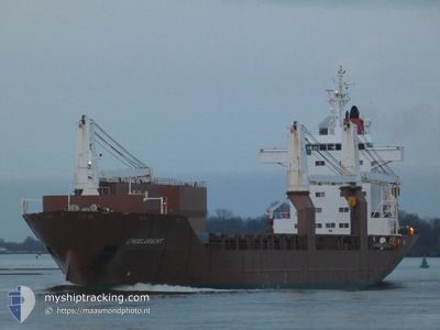
SINGELGRACHT
General Cargo
Current Trip
| Time Travelled | 1 day |
|---|---|
| Remaining Time | 2 h, 47 mins |
| Distance Travelled | 664.85 nm |
| Remaining Distance | 55.88 nm |
| AVG Speed | 16.4 Noeuds |
| MAX Speed | 19.2 Noeuds |
| AVG Wind | 9.5 knots |
| MAX Wind | 23 knots |
| MIN Temp | 9.2°C / 48.56°F |
| MAX Temp | 12.7°C / 54.86°F |
| Tirant d eau | 7.5 m |
| Position reçue | Maintenant |
Current Position
| Longitude | 2.37099° |
|---|---|
| Latitude | 51.32738° |
| Etat | Under way using engine |
| Vitesse | 17.1 Noeuds |
| Parcours | 58.5° |
| Zone | North Sea |
| Station | T-AIS |
| Position reçue | Maintenant |
Info
Information
The current position of SINGELGRACHT is in North Sea with coordinates 51.32738° / 2.37099° as reported on 2024-04-27 15:43 by AIS to our vessel tracker app. The vessel's current speed is 17.1 Noeuds and is heading at the port of VLISSINGEN. The estimated time of arrival as calculated by MyShipTracking vessel tracking app is 2024-04-27 18:30 LT
The vessel SINGELGRACHT (IMO: 9197375, MMSI: 245546000) is a General Cargo that was built in 2000 ( 24 Age ). It's sailing under the flag of [NL] Netherlands.
In this page you can find informations about the vessels current position, last detected port calls, and current voyage information. If the vessels is not in coverage by AIS you will find the latest position.
The current position of SINGELGRACHT is detected by our AIS receivers and we are not responsible for the reliability of the data. The last position was recorded while the vessel was in Coverage by the Ais receivers of our vessel tracking app.
The current draught of SINGELGRACHT as reported by AIS is 7.5 meters
Weather
| Temperature | 12°C / 53.6°F |
|---|---|
| Wind Speed | 9 knots |
| Direction | 55° NE |
| Pressure | 1003 hPa |
| Humidity | 82.7 % |
| Cloud Coverage | 100 % |
Featured Company
Last Port Calls
| Port | Arrival | Departure | Time In Port |
|---|---|---|---|
| 2024-04-24 12:46 | 2024-04-25 21:42 | 1 d | |
| 2024-04-20 19:58 | 2024-04-21 20:25 | 1 d | |
| 2024-04-20 19:28 | 2024-04-20 19:52 | 23 m | |
| 2024-04-17 13:26 | 2024-04-19 06:24 | 1 d | |
| 2024-04-16 00:18 | 2024-04-16 19:10 | 18 h | |
| 2024-03-28 14:41 | 2024-04-02 18:20 | 5 d | |
| 2024-03-13 18:42 | 2024-03-14 16:22 | 21 h | |
| 2024-03-05 20:37 | 2024-03-09 05:19 | 3 d | |
| 2024-03-03 12:08 | 2024-03-05 16:58 | 2 d | |
| 2024-02-19 12:40 | 2024-02-27 10:26 | 7 d |
Most Visited Ports (Last year)
| Port | Arrivals | |
|---|---|---|
| 4 | ||
| 3 | ||
| 3 | ||
| 2 | ||
| 2 | ||
| 2 |
Last Trips
| Origin | Departure | Destination | Arrival | Distance | |
|---|---|---|---|---|---|
| 2024-04-21 21:25 | 2024-04-24 14:46 | 498.93 nm | |||
| 2024-04-20 20:52 | 2024-04-20 20:58 | 0.23 nm | |||
| 2024-04-19 08:24 | 2024-04-20 20:28 | 524.32 nm | |||
| 2024-04-16 21:10 | 2024-04-17 15:26 | 263.77 nm | |||
| 2024-04-02 14:20 | 2024-04-16 02:18 | 3862.56 nm | |||
| 2024-03-14 16:22 | 2024-03-28 10:41 | 4587.08 nm | |||
| 2024-03-09 07:19 | 2024-03-13 18:42 | 1696.05 nm | |||
| 2024-03-05 18:58 | 2024-03-05 22:37 | 18.45 nm | |||
| 2024-02-27 11:26 | 2024-03-03 14:08 | 2034.99 nm | |||
| 2024-02-17 11:59 | 2024-02-19 13:40 | 782.44 nm |
Events
| Heure | Evenement | Détails | Position/ Destination | Info |
|---|---|---|---|---|
| 2024-04-27 13:41 | Changement de zone | French part of the North Sea French part of the English Channel |
50.99960 / 1.61538
North Sea
FLUSHING
|
Vitesse: 18.7 kn Parcours: 42.7° |
| 2024-04-27 11:40 | Etat Changé | Under way using engine Default |
50.52940 / 1.05526
FLUSHING
|
Vitesse: 17.2 kn Parcours: 53° |
| 2024-04-27 11:36 | Etat Changé | Default Under way using engine |
50.51977 / 1.03539
FLUSHING
|
Vitesse: 17.2 kn Parcours: 60.5° |
| 2024-04-27 11:31 | Etat Changé | Under way using engine Default |
50.50476 / 1.00170
FLUSHING
|
Vitesse: 17.3 kn Parcours: 66° |
| 2024-04-27 11:29 | Etat Changé | Default Under way using engine |
50.50029 / .98696
FLUSHING
|
Vitesse: 17.1 kn Parcours: 91.6° |
| 2024-04-27 11:21 | Changement de zone | French part of the English Channel United Kingdom part of the English Channel |
50.49234 / .93374
English Channel
FLUSHING
|
Vitesse: 17.1 kn Parcours: 91.6° |
| 2024-04-27 11:21 | Etat Changé | Under way using engine Default |
50.49234 / .93374
FLUSHING
|
Vitesse: 17.1 kn Parcours: 91° |
| 2024-04-27 11:20 | Etat Changé | Default Under way using engine |
50.49243 / .92856
FLUSHING
|
Vitesse: 17.1 kn Parcours: 81.7° |
| 2024-04-27 10:11 | Changement d'ETA | 2024/04/27 17:00 2024/04/27 19:00 |
50.40237 / .41355
FLUSHING
|
Vitesse: 17.9 kn Parcours: 74° |
| 2024-04-27 08:00 | Tirant d'eau modifié | 7.5 6.8 |
50.24365 / -.56282
FLUSHING
|
Vitesse: 17.1 kn Parcours: 77° |