

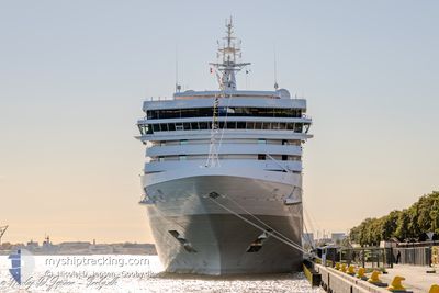
SILVER DAWN
Passenger

Current Trip
| Time Travelled | 12 h, 5 mins |
|---|---|
| Remaining Time | 16 h, 29 mins |
| Distance Travelled | 203.02 nm |
| Remaining Distance | 293.75 nm |
| AVG Speed | 17.1 Noeuds |
| MAX Speed | 18 Noeuds |
| AVG Wind | 13.9 knots |
| MAX Wind | 18 knots |
| MIN Temp | 18.2°C / 64.76°F |
| MAX Temp | 21.1°C / 69.98°F |
| Tirant d eau | 6.7 m |
| Position reçue | 2 d depuis |
Current Position
| Longitude | --- |
|---|---|
| Latitude | --- |
| Etat | Under way using engine |
| Vitesse | 15 Noeuds |
| Parcours | 354.1° |
| Zone | North Atlantic Ocean |
| Station | T-AIS |
| Position reçue | 2 d depuis |
Information
The current position of SILVER DAWN is in North Atlantic Ocean with coordinates 11.68712° / -17.35812° as reported on 2025-03-26 21:00 by AIS to our vessel tracker app. The vessel's current speed is 15 Noeuds and is heading at the port of BANJUL. The estimated time of arrival as calculated by MyShipTracking vessel tracking app is 2025-03-29 23:18 LT
The vessel SILVER DAWN (IMO: 9857937, MMSI: 311001044) is a Passenger It's sailing under the flag of [BS] Bahamas.
In this page you can find informations about the vessels current position, last detected port calls, and current voyage information. If the vessels is not in coverage by AIS you will find the latest position.
The current position of SILVER DAWN is detected by our AIS receivers and we are not responsible for the reliability of the data. The last position was recorded while the vessel was in Coverage by the Ais receivers of our vessel tracking app.
The current draught of SILVER DAWN as reported by AIS is 6.7 meters
Weather
| Temperature | 18.4°C / 65.12°F |
|---|---|
| Wind Speed | 11 knots |
| Direction | --- N |
| Pressure | 1012.9 hPa |
| Humidity | 82.8 % |
| Cloud Coverage | 100 % |


Featured Company
Last Port Calls
| Port | Arrival | Departure | Time In Port |
|---|---|---|---|
| 2025-03-28 07:20 | 2025-03-28 18:44 | 11 h | |
| 2025-03-27 07:56 | 2025-03-27 19:24 | 11 h | |
| 2025-03-23 07:24 | 2025-03-23 19:00 | 11 h | |
| 2025-03-22 07:26 | 2025-03-22 19:22 | 11 h | |
| 2025-03-18 07:16 | 2025-03-18 18:31 | 11 h | |
| 2025-03-14 12:28 | 2025-03-15 18:37 | 1 d | |
| 2025-03-13 06:47 | 2025-03-13 18:01 | 11 h | |
| 2025-03-11 06:31 | 2025-03-11 20:01 | 13 h | |
| 2025-03-08 07:36 | 2025-03-09 22:12 | 1 d | |
| 2025-03-06 09:00 | 2025-03-06 23:08 | 14 h |
Last Trips
| Origin | Departure | Destination | Arrival | Distance | |
|---|---|---|---|---|---|
| 2025-03-27 19:24 | 2025-03-28 07:20 | 105.43 nm | |||
| 2025-03-23 19:00 | 2025-03-27 07:56 | 1289.63 nm | |||
| 2025-03-22 19:22 | 2025-03-23 07:24 | 138.65 nm | |||
| 2025-03-18 18:31 | 2025-03-22 07:26 | 1175.63 nm | |||
| 2025-03-15 18:37 | 2025-03-18 07:16 | 937.54 nm | |||
| 2025-03-13 18:01 | 2025-03-14 12:28 | 263.22 nm | |||
| 2025-03-11 20:01 | 2025-03-13 06:47 | 502.03 nm | |||
| 2025-03-09 22:12 | 2025-03-11 06:31 | 458.09 nm | |||
| 2025-03-06 23:08 | 2025-03-08 07:36 | 413.23 nm | |||
| 2025-03-02 20:44 | 2025-03-06 09:00 | 1567.21 nm |
Events
| Heure | Evenement | Détails | Position/ Destination | Info |
|---|---|---|---|---|
| 2025-03-28 18:44 | Démarrage | 0.6 nm, East of DAKAR |
14.67779 / -17.41779
GM BJL
|
Vitesse: 6.6 kn Parcours: 87° |
| 2025-03-28 18:44 | PORT DE DEPART |
|
14.67779 / -17.41779
GM BJL
|
Vitesse: 3.5 kn Parcours: 12° |
| 2025-03-28 07:36 | Arret |
14.67437 / -17.42217
[SN] DAKAR
|
Vitesse: 0.1 kn Parcours: 20° |
|
| 2025-03-28 07:20 | Port d'arrivée |
|
14.67791 / -17.42155
[SN] DAKAR
|
Vitesse: 7.4 kn Parcours: 274° |
| 2025-03-28 06:56 | Démarrage | 1.54 nm, East of GOREE |
14.67184 / -17.37150
GM BJL
|
Vitesse: 5.5 kn Parcours: 292° |
| 2025-03-28 06:36 | Arret | 1.74 nm, East of GOREE |
14.67283 / -17.36822
GM BJL
|
Vitesse: 0.3 kn Parcours: 2° |
| 2025-03-27 19:24 | Démarrage | 0.52 nm, North East of BANJUL |
13.45177 / -16.56433
GM BJL
|
Vitesse: 5.7 kn Parcours: 18° |
| 2025-03-27 19:24 | PORT DE DEPART |
|
13.45177 / -16.56433
GM BJL
|
Vitesse: 3.9 kn Parcours: 36° |
| 2025-03-27 08:01 | Arret |
13.44632 / -16.57011
[GM] BANJUL
|
Vitesse: Parcours: 28° |
|
| 2025-03-27 07:56 | Port d'arrivée |
|
13.44610 / -16.56974
[GM] BANJUL
|
Vitesse: 0.9 kn Parcours: 31° |