
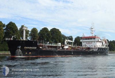
SAN BACCO
Tanker
Current Trip
| Time Travelled | 7 h, 48 mins |
|---|---|
| Remaining Time | --- |
| Distance Travelled | 91.22 nm |
| Remaining Distance | --- |
| AVG Speed | 10.9 Noeuds |
| MAX Speed | 13.1 Noeuds |
| AVG Wind | 7.4 knots |
| MAX Wind | 16.4 knots |
| MIN Temp | 8.2°C / 46.76°F |
| MAX Temp | 12.6°C / 54.68°F |
| Tirant d eau | 6.7 m |
| Position reçue | 34 m depuis |
Current Position
| Longitude | -3.87065° |
|---|---|
| Latitude | 47.39248° |
| Etat | Under way using engine |
| Vitesse | 12 Noeuds |
| Parcours | 300.8° |
| Zone | Bay of Biscay |
| Station | T-AIS |
| Position reçue | 34 m depuis |
Info
Information
The current position of SAN BACCO is in Bay of Biscay with coordinates 47.39248° / -3.87065° as reported on 2024-04-29 13:40 by AIS to our vessel tracker app. The vessel's current speed is 12 Noeuds and is heading at the port of MALMO. The estimated time of arrival as calculated by MyShipTracking vessel tracking app is 2024-05-03 02:00 LT
The vessel SAN BACCO (IMO: 9753818, MMSI: 256831000) is a Tanker It's sailing under the flag of [MT] Malta.
In this page you can find informations about the vessels current position, last detected port calls, and current voyage information. If the vessels is not in coverage by AIS you will find the latest position.
The current position of SAN BACCO is detected by our AIS receivers and we are not responsible for the reliability of the data. The last position was recorded while the vessel was in Coverage by the Ais receivers of our vessel tracking app.
The current draught of SAN BACCO as reported by AIS is 6.7 meters
Weather
| Temperature | 12.5°C / 54.5°F |
|---|---|
| Wind Speed | 16 knots |
| Direction | 208° SSW |
| Pressure | 1016 hPa |
| Humidity | 74.8 % |
| Cloud Coverage | 100 % |
Featured Company
Last Port Calls
| Port | Arrival | Departure | Time In Port |
|---|---|---|---|
| 2024-04-28 06:06 | 2024-04-29 06:26 | 1 d | |
| 2024-04-21 10:54 | 2024-04-23 01:41 | 1 d | |
| 2024-04-18 16:20 | 2024-04-19 21:16 | 1 d | |
| 2024-04-16 11:56 | 2024-04-17 06:30 | 18 h | |
| 2024-04-11 17:06 | 2024-04-12 18:18 | 1 d | |
| 2024-04-11 08:03 | 2024-04-11 08:54 | 50 m | |
| 2024-04-08 11:51 | 2024-04-09 05:47 | 17 h | |
| 2024-04-05 21:43 | |||
| 2024-04-04 17:53 | |||
| 2024-04-04 17:53 |
Last Trips
| Origin | Departure | Destination | Arrival | Distance | |
|---|---|---|---|---|---|
| 2024-04-23 02:41 | 2024-04-28 08:06 | 882.27 nm | |||
| 2024-04-19 23:16 | 2024-04-21 11:54 | 393.72 nm | |||
| 2024-04-17 07:30 | 2024-04-18 18:20 | 400.38 nm | |||
| 2024-04-12 20:18 | 2024-04-16 12:56 | 401.33 nm | |||
| 2024-04-11 10:54 | 2024-04-11 19:06 | 48.59 nm | |||
| 2024-04-09 08:47 | 2024-04-11 10:03 | 655.97 nm | |||
| 2024-04-05 23:43 | 2024-04-08 14:51 | 715.37 nm | |||
| 2024-04-04 11:51 | 2024-04-04 19:53 | 49.10 nm | |||
| 2024-04-04 11:51 | 2024-04-04 19:45 | 48.76 nm | |||
| 2024-04-02 08:39 | 2024-04-04 11:08 | 654.54 nm |
Events
| Heure | Evenement | Détails | Position/ Destination | Info |
|---|---|---|---|---|
| 2024-04-29 13:46 | Etat Changé | Default Under way using engine |
47.40167 / -3.89667
SEMMA-VIA NOK
|
Vitesse: 12 kn Parcours: 300.8° |
| 2024-04-29 11:55 | Etat Changé | Under way using engine Default |
47.22176 / -3.41284
SEMMA-VIA NOK
|
Vitesse: 12.2 kn Parcours: 297° |
| 2024-04-29 11:55 | Dans la zone couverte |
47.22176 / -3.41284
Bay of Biscay
SEMMA-VIA NOK
|
Vitesse: 12.3 kn Parcours: 296.3° |
|
| 2024-04-29 10:28 | Etat Changé | Default Under way using engine |
47.09833 / -3.01500
SEMMA-VIA NOK
|
Vitesse: 12.6 kn Parcours: 290.5° |
| 2024-04-29 10:24 | Hors de la zone couverte |
47.09460 / -2.99837
Bay of Biscay
SEMMA-VIA NOK
|
Vitesse: 12.6 kn Parcours: 290.5° |
|
| 2024-04-29 09:39 | Etat Changé | Under way using engine Default |
47.03687 / -2.78050
SEMMA-VIA NOK
|
Vitesse: 12 kn Parcours: 289° |
| 2024-04-29 09:37 | Etat Changé | Default Under way using engine |
47.03500 / -2.77500
SEMMA-VIA NOK
|
Vitesse: 12.5 kn Parcours: 289.4° |
| 2024-04-29 08:58 | Etat Changé | Under way using engine Default |
47.03613 / -2.58849
SEMMA-VIA NOK
|
Vitesse: 12.6 kn Parcours: 248° |
| 2024-04-29 08:53 | Etat Changé | Default Under way using engine |
47.04180 / -2.56779
SEMMA-VIA NOK
|
Vitesse: 12.6 kn Parcours: 247.4° |
| 2024-04-29 08:12 | Changement d'ETA | 2024/05/03 02:00 2024/05/03 01:00 |
47.11238 / -2.38547
SEMMA-VIA NOK
|
Vitesse: 11.8 kn Parcours: 227.4° |