
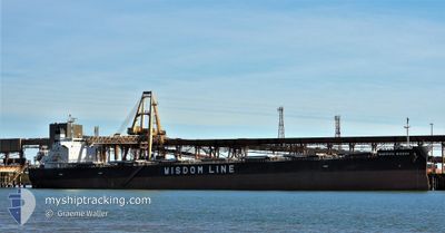
SAKIZAYA WISDOM
Bulk Carrier
Current Trip
| Trip Time | 4 days |
|---|---|
| Trip Distance | 566.10 nm |
| AVG Speed | 10.6 Noeuds |
| MAX Speed | 14.3 Noeuds |
| Tirant d eau | 14.1 m |
| AVG Wind | 11.7 knots |
| MAX Wind | 25.8 knots |
| MIN Temp | 12.5°C / 54.5°F |
| MAX Temp | 18.8°C / 65.84°F |
| Position reçue | 4 d depuis |
Current Position
| Longitude | 122.94251° |
|---|---|
| Latitude | 36.17144° |
| Etat | Under way using engine |
| Vitesse | 11.8 Noeuds |
| Parcours | 223.6° |
| Zone | Yellow Sea |
| Station | T-AIS |
| Position reçue | 4 d depuis |
Info
Information
The current position of SAKIZAYA WISDOM is in Yellow Sea with coordinates 36.17144° / 122.94251° as reported on 2024-05-09 13:13 by AIS to our vessel tracker app. The vessel's current speed is 11.8 Noeuds and is currently inside the port of RIZHAO.
The vessel SAKIZAYA WISDOM (IMO: 9460590, MMSI: 355860000) is a Bulk Carrier that was built in 2011 ( 13 Age ). It's sailing under the flag of [PA] Panama.
In this page you can find informations about the vessels current position, last detected port calls, and current voyage information. If the vessels is not in coverage by AIS you will find the latest position.
The current position of SAKIZAYA WISDOM is detected by our AIS receivers and we are not responsible for the reliability of the data. The last position was recorded while the vessel was in Coverage by the Ais receivers of our vessel tracking app.
The current draught of SAKIZAYA WISDOM as reported by AIS is 14.1 meters
Weather
| Temperature | 15.7°C / 60.26°F |
|---|---|
| Wind Speed | 6 knots |
| Direction | 213° SSW |
| Pressure | 1013.1 hPa |
| Humidity | 87.3 % |
| Cloud Coverage | --- |
Featured Company
Last Port Calls
| Port | Arrival | Departure | Time In Port |
|---|---|---|---|
| 2024-05-13 00:28 | |||
| 2024-05-03 18:00 | 2024-05-08 07:48 | 4 d | |
| 2024-04-15 01:54 | 2024-04-18 09:27 | 3 d | |
| 2024-03-20 04:48 | 2024-03-26 14:45 | 6 d |
Most Visited Ports (Last year)
| Port | Arrivals | |
|---|---|---|
| 2 | ||
| 1 | ||
| 1 | ||
| 1 | ||
| 1 | ||
| 1 |
Last Trips
| Origin | Departure | Destination | Arrival | Distance | |
|---|---|---|---|---|---|
| 2024-05-08 15:48 | 2024-05-13 08:28 | 566.10 nm | |||
| 2024-04-18 17:27 | 2024-05-04 02:00 | 3924.77 nm | |||
| 2024-03-26 22:45 | 2024-04-15 09:54 | 4019.44 nm | |||
| 2024-01-30 05:55 | 2024-03-20 12:48 | 11635.63 nm |
Events
| Heure | Evenement | Détails | Position/ Destination | Info |
|---|---|---|---|---|
| 2024-05-13 01:00 | Arret |
35.33695 / 119.53425
[CN] RIZHAO
|
Vitesse: Parcours: 180° |
|
| 2024-05-13 00:28 | Port d'arrivée |
|
35.33836 / 119.55589
[CN] RIZHAO
|
Vitesse: 9 kn Parcours: 298° |
| 2024-05-12 21:28 | Démarrage | 11.28 nm, South East of RIZHAO |
35.23568 / 119.74006
TIANJIN
|
Vitesse: 3.7 kn Parcours: 330° |
| 2024-05-11 13:40 | Arret | 12.24 nm, South East of RIZHAO |
35.21975 / 119.75178
TIANJIN
|
Vitesse: 0.2 kn Parcours: 270° |
| 2024-05-11 10:44 | Démarrage | 20.8 nm, South East of DONGJIAKOU |
35.35035 / 120.10772
TIANJIN
|
Vitesse: 4.9 kn Parcours: 156° |
| 2024-05-10 04:10 | Arret | 20.44 nm, South East of DONGJIAKOU |
35.35667 / 120.10500
TIANJIN
|
Vitesse: Parcours: -1° |
| 2024-05-09 23:45 | Démarrage |
35.32876 / 120.74570
TIANJIN
|
Vitesse: 4.5 kn Parcours: 262° |
|
| 2024-05-09 23:34 | Arret |
35.32834 / 120.75166
TIANJIN
|
Vitesse: Parcours: -1° |
|
| 2024-05-09 13:20 | Etat Changé | Default Under way using engine |
36.15396 / 122.91999
TIANJIN
|
Vitesse: 11.8 kn Parcours: 223.6° |
| 2024-05-09 13:13 | Hors de la zone couverte |
36.17144 / 122.94251
Yellow Sea
|
Vitesse: 11.8 kn Parcours: 223.6° |