
RISING TIDE
Cargo
Current Trip
JP FKY
| Time Travelled | 3 days |
|---|---|
| Remaining Time | --- |
| Distance Travelled | 942.80 nm |
| Remaining Distance | --- |
| AVG Speed | 11.4 Noeuds |
| MAX Speed | 14.6 Noeuds |
| AVG Wind | 8.5 knots |
| MAX Wind | 27 knots |
| MIN Temp | 19.9°C / 67.82°F |
| MAX Temp | 27.6°C / 81.68°F |
| Tirant d eau | 5.3 m |
| Position reçue | 3 h, 23 m depuis |
Current Position
| Longitude | 121.20752° |
|---|---|
| Latitude | 25.27771° |
| Etat | Under way using engine |
| Vitesse | 11.6 Noeuds |
| Parcours | 230.2° |
| Zone | South China Sea |
| Station | T-AIS |
| Position reçue | 3 h, 23 m depuis |
Info
Information
The current position of RISING TIDE is in South China Sea with coordinates 25.27771° / 121.20752° as reported on 2024-06-18 10:20 by AIS to our vessel tracker app. The vessel's current speed is 11.6 Noeuds
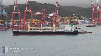
The vessel RISING TIDE (IMO: 9889693, MMSI: 372552000) is a Cargo It's sailing under the flag of [PA] Panama.
In this page you can find informations about the vessels current position, last detected port calls, and current voyage information. If the vessels is not in coverage by AIS you will find the latest position.
The current position of RISING TIDE is detected by our AIS receivers and we are not responsible for the reliability of the data. The last position was recorded while the vessel was in Coverage by the Ais receivers of our vessel tracking app.
The current draught of RISING TIDE as reported by AIS is 5.3 meters
Weather
| Temperature | 26.8°C / 80.24°F |
|---|---|
| Wind Speed | 2 knots |
| Direction | 302° WNW |
| Pressure | 1008.7 hPa |
| Humidity | 88.7 % |
| Cloud Coverage | 100 % |
Featured Company
Last Port Calls
| Port | Arrival | Departure | Time In Port |
|---|---|---|---|
| 2024-06-10 20:17 | 2024-06-14 22:53 | 4 d | |
| 2024-06-04 04:39 | 2024-06-06 07:09 | 2 d | |
| 2024-05-20 08:36 | 2024-05-21 03:40 | 19 h | |
| 2024-05-07 06:12 | 2024-05-11 06:04 | 3 d | |
| 2024-04-28 10:16 | 2024-04-30 00:48 | 1 d | |
| 2024-04-22 07:12 | 2024-04-24 00:56 | 1 d | |
| 2024-04-08 20:40 | 2024-04-12 06:26 | 3 d | |
| 2024-04-07 05:41 |
Most Visited Ports (Last year)
| Port | Arrivals | |
|---|---|---|
| 3 | ||
| 3 | ||
| 3 | ||
| 2 | ||
| 2 | ||
| 2 |
Last Trips
| Origin | Departure | Destination | Arrival | Distance | |
|---|---|---|---|---|---|
| 2024-06-06 16:09 | 2024-06-11 05:17 | 33.74 nm | |||
| 2024-05-21 11:40 | 2024-06-04 13:39 | 1063.09 nm | |||
| 2024-05-11 15:04 | 2024-05-20 16:36 | 864.69 nm | |||
| 2024-04-30 07:48 | 2024-05-07 15:12 | 1834.13 nm | |||
| 2024-04-24 07:56 | 2024-04-28 17:16 | 1311.31 nm | |||
| 2024-04-12 15:26 | 2024-04-22 14:12 | 2853.73 nm | |||
| 2024-04-07 14:41 | 2024-04-09 05:40 | 411.13 nm |
Events
| Heure | Evenement | Détails | Position/ Destination | Info |
|---|---|---|---|---|
| 2024-06-18 10:30 | Etat Changé | Default Under way using engine |
25.25858 / 121.17886
JP FKY
|
Vitesse: 11.6 kn Parcours: 230.2° |
| 2024-06-18 10:20 | Hors de la zone couverte |
25.27771 / 121.20752
South China Sea
|
Vitesse: 11.6 kn Parcours: 230.2° |
|
| 2024-06-18 10:10 | Changement de zone | Taiwanese part of the South China Sea Taiwanese part of the Eastern China Sea |
25.30021 / 121.23647
South China Sea
|
Vitesse: 12.1 kn Parcours: 227.8° |
| 2024-06-18 10:08 | Etat Changé | Under way using engine Default |
25.30391 / 121.24109
JP FKY
|
Vitesse: 12 kn Parcours: 234° |
| 2024-06-18 09:52 | Etat Changé | Default Under way using engine |
25.33843 / 121.29081
JP FKY
|
Vitesse: 12.9 kn Parcours: 233.8° |
| 2024-06-18 09:40 | Etat Changé | Under way using engine Default |
25.36279 / 121.32696
JP FKY
|
Vitesse: 13 kn Parcours: 232° |
| 2024-06-18 09:40 | Dans la zone couverte |
25.36279 / 121.32696
Eastern China Sea
|
Vitesse: 12.9 kn Parcours: 233.8° |
|
| 2024-06-18 06:07 | Etat Changé | Default Under way using engine |
25.73915 / 122.01085
JP FKY
|
Vitesse: 11.6 kn Parcours: 235.8° |
| 2024-06-18 05:57 | Detecté en mer | Taiwanese part of the Eastern China Sea |
25.75625 / 122.03960
Eastern China Sea
|
Vitesse: 11.6 kn Parcours: 235.8° |
| 2024-06-18 05:57 | Hors de la zone couverte |
25.75625 / 122.03960
Eastern China Sea
|
Vitesse: 11.6 kn Parcours: 235.8° |