
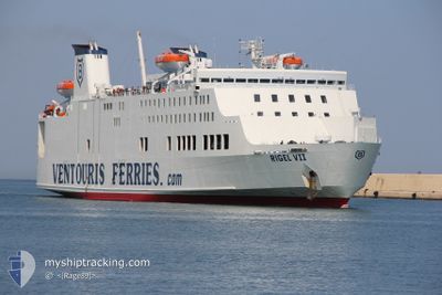
RIGEL VII
Passenger
Current Trip
| Trip Time | 7 h, 38 mins |
|---|---|
| Trip Distance | 121.86 nm |
| AVG Speed | 15.3 Noeuds |
| MAX Speed | 16.9 Noeuds |
| Tirant d eau | 5.5 m |
| AVG Wind | 22.7 knots |
| MAX Wind | 25 knots |
| MIN Temp | 13.9°C / 57.02°F |
| MAX Temp | 16.6°C / 61.88°F |
| Position reçue | 14 h, 1 m depuis |
Current Position
| Longitude | --- |
|---|---|
| Latitude | --- |
| Etat | Under way using engine |
| Vitesse | 16.4 Noeuds |
| Parcours | 264.5° |
| Zone | Adriatic Sea |
| Station | T-AIS |
| Position reçue | 14 h, 1 m depuis |
Info
Information
The current position of RIGEL VII is in Adriatic Sea with coordinates 41.19250° / 17.16140° as reported on 2024-11-21 07:29 by AIS to our vessel tracker app. The vessel's current speed is 16.4 Noeuds and is currently inside the port of BARI.
The vessel RIGEL VII (IMO: 9087726, MMSI: 209481000) is a Passenger It's sailing under the flag of [CY] Cyprus.
In this page you can find informations about the vessels current position, last detected port calls, and current voyage information. If the vessels is not in coverage by AIS you will find the latest position.
The current position of RIGEL VII is detected by our AIS receivers and we are not responsible for the reliability of the data. The last position was recorded while the vessel was in Coverage by the Ais receivers of our vessel tracking app.
The current draught of RIGEL VII as reported by AIS is 5.5 meters
Weather
| Temperature | 15.7°C / 60.26°F |
|---|---|
| Wind Speed | 17 knots |
| Direction | 193° SSW |
| Pressure | 1006.5 hPa |
| Humidity | 66 % |
| Cloud Coverage | 8 % |
Featured Company
Last Port Calls
| Port | Arrival | Departure | Time In Port |
|---|---|---|---|
| 2024-11-21 09:02 | |||
| 2024-11-20 07:13 | 2024-11-21 01:24 | 18 h | |
| 2024-11-19 07:16 | 2024-11-19 23:10 | 15 h | |
| 2024-11-18 07:13 | 2024-11-18 23:30 | 16 h | |
| 2024-11-17 07:34 | 2024-11-17 23:11 | 15 h | |
| 2024-11-16 07:51 | 2024-11-16 23:04 | 15 h | |
| 2024-11-15 07:28 | 2024-11-15 23:47 | 16 h | |
| 2024-11-14 07:20 | 2024-11-14 23:07 | 15 h | |
| 2024-11-13 07:26 | 2024-11-13 23:52 | 16 h | |
| 2024-11-12 07:19 | 2024-11-12 23:22 | 16 h |
Most Visited Ports (Last year)
| Port | Arrivals | |
|---|---|---|
| 187 | ||
| 135 | ||
| 54 | ||
| 16 |
Last Trips
| Origin | Departure | Destination | Arrival | Distance | |
|---|---|---|---|---|---|
| 2024-11-21 01:24 | 2024-11-21 09:02 | 121.86 nm | |||
| 2024-11-19 23:10 | 2024-11-20 07:13 | 121.17 nm | |||
| 2024-11-18 23:30 | 2024-11-19 07:16 | 122.79 nm | |||
| 2024-11-17 23:11 | 2024-11-18 07:13 | 121.34 nm | |||
| 2024-11-16 23:04 | 2024-11-17 07:34 | 121.30 nm | |||
| 2024-11-15 23:47 | 2024-11-16 07:51 | 128.35 nm | |||
| 2024-11-14 23:07 | 2024-11-15 07:28 | 122.45 nm | |||
| 2024-11-13 23:52 | 2024-11-14 07:20 | 121.17 nm | |||
| 2024-11-12 23:22 | 2024-11-13 07:26 | 122.30 nm | |||
| 2024-11-11 23:56 | 2024-11-12 07:19 | 120.51 nm |
Events
| Heure | Evenement | Détails | Position/ Destination | Info |
|---|---|---|---|---|
| 2024-11-21 08:20 | Arret |
41.13388 / 16.86447
[IT] BARI
|
Vitesse: 0.2 kn Parcours: 312° |
|
| 2024-11-21 08:02 | Port d'arrivée |
|
41.13998 / 16.85595
[IT] BARI
|
Vitesse: 9.4 kn Parcours: 166° |
| 2024-11-21 07:51 | Etat Changé | Default Under way using engine |
41.17130 / 16.84412
BARI-DURRES-BARI
|
Vitesse: 16.4 kn Parcours: 264.5° |
| 2024-11-21 07:29 | Hors de la zone couverte |
41.19250 / 17.16140
Adriatic Sea
[IT] BARI
|
Vitesse: 16.4 kn Parcours: 264.5° |
|
| 2024-11-21 05:09 | Detecté en mer | Italian part of the Adriatic Sea |
41.21512 / 17.77325
Adriatic Sea
BARI-DURRES-BARI
|
Vitesse: 16.9 kn Parcours: 268.1° |
| 2024-11-21 05:09 | Dans la zone couverte |
41.21512 / 17.77325
Adriatic Sea
BARI-DURRES-BARI
|
Vitesse: 16.9 kn Parcours: 268.1° |
|
| 2024-11-21 03:09 | Hors de la zone couverte |
41.25240 / 18.67430
Adriatic Sea
BARI-DURRES-BARI
|
Vitesse: 16.7 kn Parcours: 266.1° |
|
| 2024-11-21 03:09 | Dans la zone couverte |
41.25240 / 18.67430
Adriatic Sea
BARI-DURRES-BARI
|
Vitesse: 16.7 kn Parcours: 266.1° |
|
| 2024-11-21 01:33 | Hors de la zone couverte |
41.26750 / 19.34930
Adriatic Sea
BARI-DURRES-BARI
|
Vitesse: 16.1 kn Parcours: 265.3° |
|
| 2024-11-21 00:45 | Changement d'ETA | 2024/11/21 08:00 2024/11/20 08:00 |
41.26974 / 19.38394
BARI-DURRES-BARI
|
Vitesse: 16.2 kn Parcours: 265.6° |