
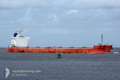
PAREA
Bulk Carrier
Current Trip
HALDIA
| Time Travelled | 8 days |
|---|---|
| Remaining Time | --- |
| Distance Travelled | 2589.32 nm |
| Remaining Distance | --- |
| AVG Speed | 12.3 Noeuds |
| MAX Speed | 12.3 Noeuds |
| AVG Wind | 9.4 knots |
| MAX Wind | 17 knots |
| MIN Temp | 26.1°C / 78.98°F |
| MAX Temp | 30.9°C / 87.62°F |
| Tirant d eau | 7.1 m |
| Position reçue | 2 d depuis |
Current Position
| Longitude | 77.52119° |
|---|---|
| Latitude | 7.30503° |
| Etat | Under way using engine |
| Vitesse | 12.5 Noeuds |
| Parcours | 124.7° |
| Zone | Laccadive Sea |
| Station | T-AIS |
| Position reçue | 2 d depuis |
Info
Information
The current position of PAREA is in Laccadive Sea with coordinates 7.30503° / 77.52119° as reported on 2024-05-01 08:28 by AIS to our vessel tracker app. The vessel's current speed is 12.5 Noeuds
The vessel PAREA (IMO: 9433652, MMSI: 248695000) is a Bulk Carrier that was built in 2012 ( 12 Age ). It's sailing under the flag of [MT] Malta.
In this page you can find informations about the vessels current position, last detected port calls, and current voyage information. If the vessels is not in coverage by AIS you will find the latest position.
The current position of PAREA is detected by our AIS receivers and we are not responsible for the reliability of the data. The last position was recorded while the vessel was in Coverage by the Ais receivers of our vessel tracking app.
The current draught of PAREA as reported by AIS is 7.1 meters
Weather
| Temperature | 29.8°C / 85.64°F |
|---|---|
| Wind Speed | 11 knots |
| Direction | 227° SW |
| Pressure | 1009.9 hPa |
| Humidity | 82.2 % |
| Cloud Coverage | 22 % |
Featured Company
Last Port Calls
| Port | Arrival | Departure | Time In Port |
|---|---|---|---|
| 2024-04-22 15:52 | 2024-04-25 14:28 | 2 d | |
| 2024-04-20 12:04 | 2024-04-20 23:17 | 11 h | |
| 2024-04-08 06:15 | 2024-04-08 15:18 | 9 h |
Events
| Heure | Evenement | Détails | Position/ Destination | Info |
|---|---|---|---|---|
| 2024-05-01 08:32 | Etat Changé | Default Under way using engine |
7.29667 / 77.53167
HALDIA
|
Vitesse: 12.5 kn Parcours: 124.7° |
| 2024-05-01 08:28 | Etat Changé | Under way using engine Default |
7.30503 / 77.52119
HALDIA
|
Vitesse: 12 kn Parcours: 124° |
| 2024-05-01 08:28 | Hors de la zone couverte |
7.30503 / 77.52119
Laccadive Sea
HALDIA
|
Vitesse: 12.5 kn Parcours: 124.7° |
|
| 2024-05-01 07:53 | Etat Changé | Default Under way using engine |
7.37333 / 77.41833
HALDIA
|
Vitesse: 12.2 kn Parcours: 124.5° |
| 2024-05-01 07:19 | Etat Changé | Under way using engine Default |
7.44206 / 77.32128
HALDIA
|
Vitesse: 12 kn Parcours: 124° |
| 2024-05-01 06:53 | Etat Changé | Default Under way using engine |
7.49333 / 77.24500
HALDIA
|
Vitesse: 12.4 kn Parcours: 125.5° |
| 2024-05-01 06:35 | Etat Changé | Under way using engine Default |
7.53224 / 77.19329
HALDIA
|
Vitesse: 12 kn Parcours: 130° |
| 2024-05-01 06:29 | Etat Changé | Default Under way using engine |
7.54333 / 77.17834
HALDIA
|
Vitesse: 12.2 kn Parcours: 132.1° |
| 2024-05-01 03:58 | Etat Changé | Under way using engine Default |
7.88517 / 76.78747
HALDIA
|
Vitesse: 12 kn Parcours: 128° |
| 2024-05-01 03:41 | Etat Changé | Default Under way using engine |
7.91833 / 76.74167
HALDIA
|
Vitesse: 12.3 kn Parcours: 128.8° |