
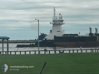
PACIFIC RELIANCE
Articulated Pusher Tug
Current Trip
| Trip Time | 1 day |
|---|---|
| Trip Distance | 93.74 nm |
| AVG Speed | 6.6 Noeuds |
| MAX Speed | 7.8 Noeuds |
| Tirant d eau | 9.2 m |
| AVG Wind | 4.2 knots |
| MAX Wind | 10 knots |
| MIN Temp | 10.1°C / 50.18°F |
| MAX Temp | 23.4°C / 74.12°F |
| Position reçue | 2 d depuis |
Current Position
| Longitude | --- |
|---|---|
| Latitude | --- |
| Etat | Under way using engine |
| Vitesse | 6.8 Noeuds |
| Parcours | 271° |
| Zone | Gulf of Mexico |
| Station | T-AIS |
| Position reçue | 2 d depuis |
Info
Information
The current position of PACIFIC RELIANCE is in Gulf of Mexico with coordinates 29.97070° / -90.25959° as reported on 2025-02-27 06:13 by AIS to our vessel tracker app. The vessel's current speed is 6.8 Noeuds and is currently inside the port of PORT ALLEN.
The vessel PACIFIC RELIANCE (IMO: 9386548, MMSI: 367036000) is a Articulated Pusher Tug that was built in 2006 ( 19 Age ). It's sailing under the flag of [US] USA.
In this page you can find informations about the vessels current position, last detected port calls, and current voyage information. If the vessels is not in coverage by AIS you will find the latest position.
The current position of PACIFIC RELIANCE is detected by our AIS receivers and we are not responsible for the reliability of the data. The last position was recorded while the vessel was in Coverage by the Ais receivers of our vessel tracking app.
The current draught of PACIFIC RELIANCE as reported by AIS is 9.2 meters
Weather
| Temperature | 22.7°C / 72.86°F |
|---|---|
| Wind Speed | 8 knots |
| Direction | 343° NNW |
| Pressure | 1015.1 hPa |
| Humidity | 48.7 % |
| Cloud Coverage | --- |
Featured Company
Last Port Calls
| Port | Arrival | Departure | Time In Port |
|---|---|---|---|
| 2025-02-28 08:11 | |||
| 2025-02-26 18:53 | 2025-02-27 01:23 | 6 h | |
| 2025-02-24 22:43 | 2025-02-24 23:36 | 53 m | |
| 2025-02-22 13:05 | 2025-02-22 13:49 | 43 m | |
| 2025-02-20 21:02 | 2025-02-20 22:42 | 1 h | |
| 2025-02-19 08:15 | 2025-02-20 12:55 | 1 d | |
| 2025-02-16 00:44 | 2025-02-16 01:40 | 55 m | |
| 2025-02-07 22:22 | 2025-02-08 10:27 | 12 h | |
| 2025-02-06 14:19 | 2025-02-07 16:39 | 1 d | |
| 2025-02-05 06:21 | 2025-02-05 11:47 | 5 h |
Most Visited Ports (Last year)
| Port | Arrivals | |
|---|---|---|
| 31 | ||
| 29 | ||
| 19 | ||
| 9 | ||
| 6 | ||
| 5 |
Last Trips
| Origin | Departure | Destination | Arrival | Distance | |
|---|---|---|---|---|---|
| 2025-02-27 01:23 | 2025-02-28 08:11 | 93.74 nm | |||
| 2025-02-24 23:36 | 2025-02-26 18:53 | 416.54 nm | |||
| 2025-02-22 13:49 | 2025-02-24 22:43 | 45.94 nm | |||
| 2025-02-20 22:42 | 2025-02-22 13:05 | 405.42 nm | |||
| 2025-02-20 12:55 | 2025-02-20 21:02 | 117.86 nm | |||
| 2025-02-16 01:40 | 2025-02-19 08:15 | 545.57 nm | |||
| 2025-02-08 10:27 | 2025-02-16 00:44 | 533.15 nm | |||
| 2025-02-07 16:39 | 2025-02-07 22:22 | 71.59 nm | |||
| 2025-02-05 11:47 | 2025-02-06 14:19 | 93.43 nm | |||
| 2025-01-30 11:19 | 2025-02-05 06:21 | 575.30 nm |
Events
| Heure | Evenement | Détails | Position/ Destination | Info |
|---|---|---|---|---|
| 2025-02-28 14:12 | Arret |
30.43674 / -91.20023
[US] PORT ALLEN
|
Vitesse: 0.1 kn Parcours: 3° |
|
| 2025-02-28 14:11 | Port d'arrivée |
|
30.43674 / -91.20023
[US] PORT ALLEN
|
Vitesse: 0.6 kn Parcours: 344° |
| 2025-02-28 11:00 | Démarrage | 0.42 nm, South East of PLAQUEMINE |
30.28376 / -91.21571
GRANDVIEW ANCHORAGE
|
Vitesse: 4.8 kn Parcours: 294° |
| 2025-02-28 10:36 | Arret | 0.6 nm, South East of PLAQUEMINE |
30.28240 / -91.21232
GRANDVIEW ANCHORAGE
|
Vitesse: 0.1 kn Parcours: 293° |
| 2025-02-28 02:15 | Démarrage | 0.3 nm, East of LUTCHER |
30.03667 / -90.68971
GRANDVIEW ANCHORAGE
|
Vitesse: 5.3 kn Parcours: 234° |
| 2025-02-27 10:47 | Arret | 0.56 nm, North East of LUTCHER |
30.04015 / -90.68584
GRANDVIEW ANCHORAGE
|
Vitesse: 0.1 kn Parcours: 244° |
| 2025-02-27 07:23 | PORT DE DEPART |
|
29.95158 / -90.39181
GRANDVIEW ANCHORAGE
|
Vitesse: 6.8 kn Parcours: 308° |
| 2025-02-27 06:20 | Etat Changé | Default Under way using engine |
29.96942 / -90.27445
[US] NEW ORLEANS
|
Vitesse: 6.8 kn Parcours: 271° |
| 2025-02-27 06:13 | Hors de la zone couverte |
29.97070 / -90.25959
Gulf of Mexico
[US] NEW ORLEANS
|
Vitesse: 6.8 kn Parcours: 276° |
|
| 2025-02-27 06:08 | Etat Changé | Under way using engine Default |
29.96907 / -90.24919
[US] NEW ORLEANS
|
Vitesse: 6.6 kn Parcours: 294° |